-
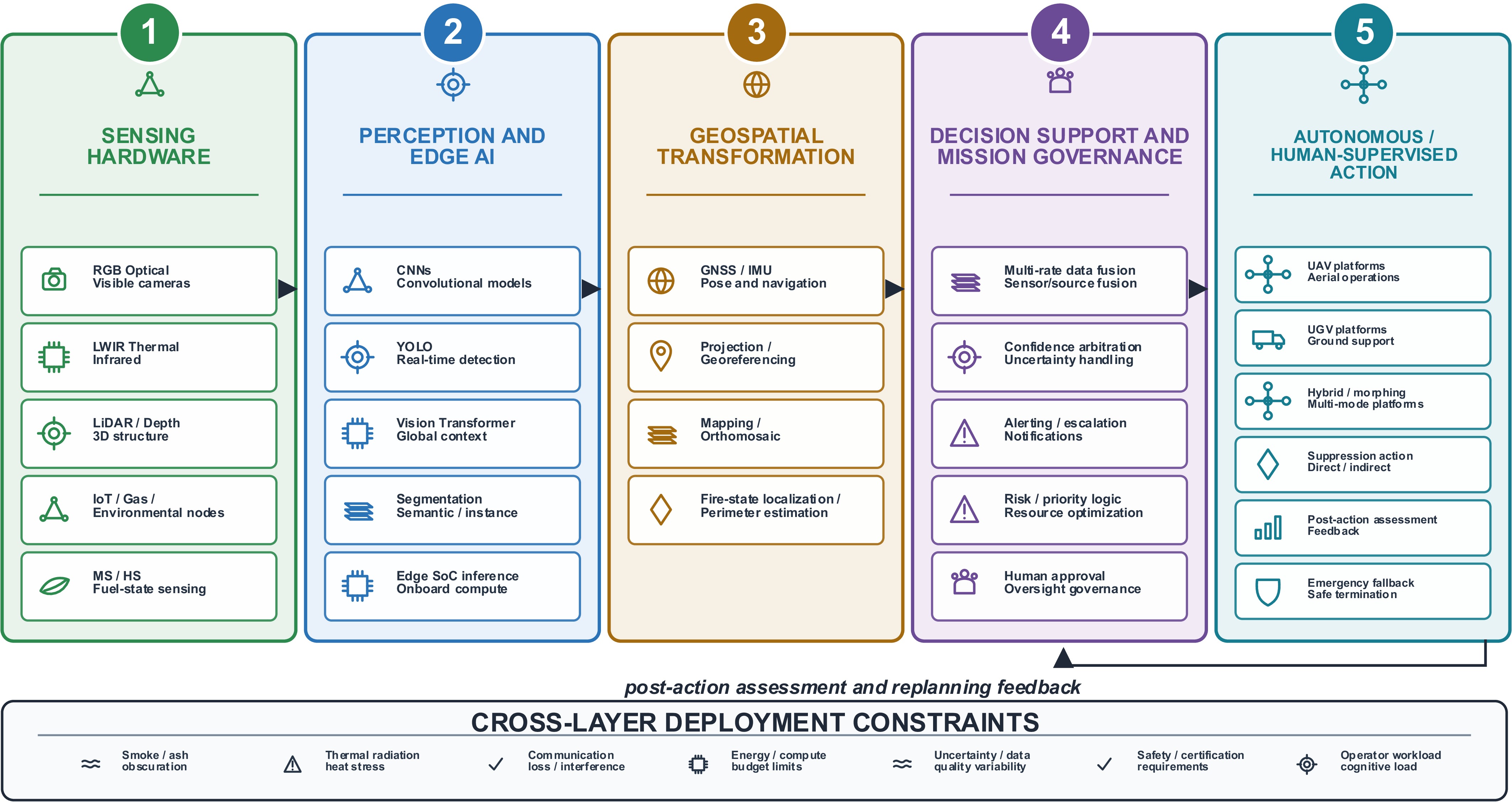
Figure 1.
Five-layer wildfire decision taxonomy.
-
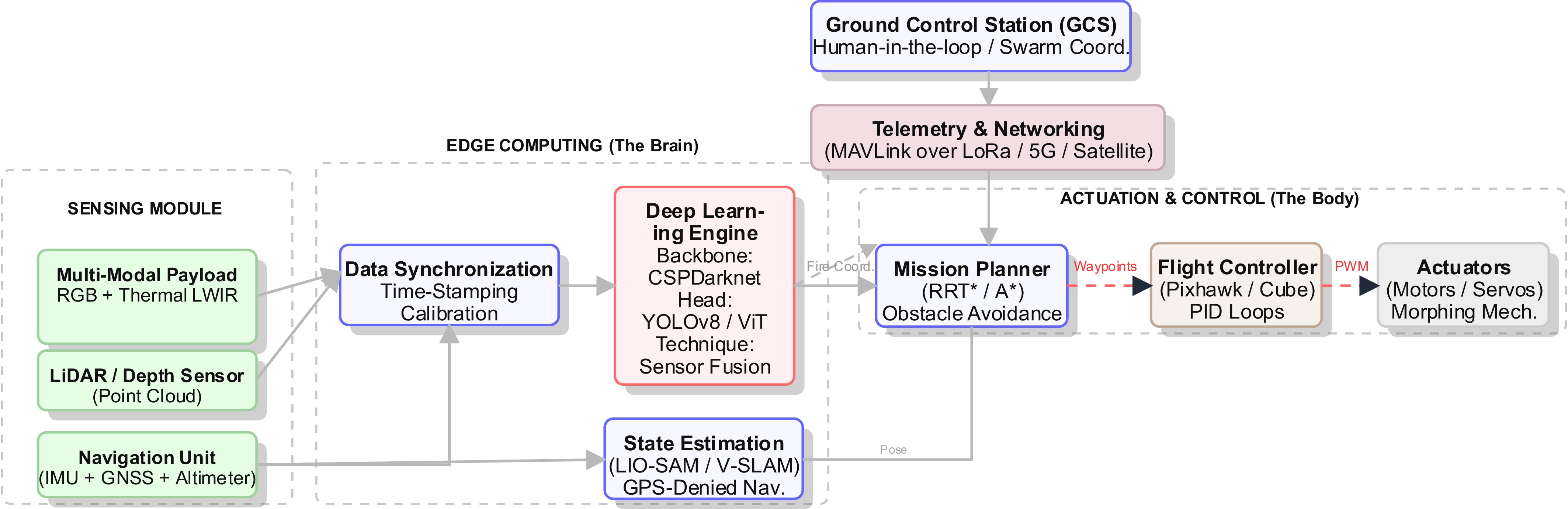
Figure 2.
The deployable UAV/UGV wildfire system's architecture.
-
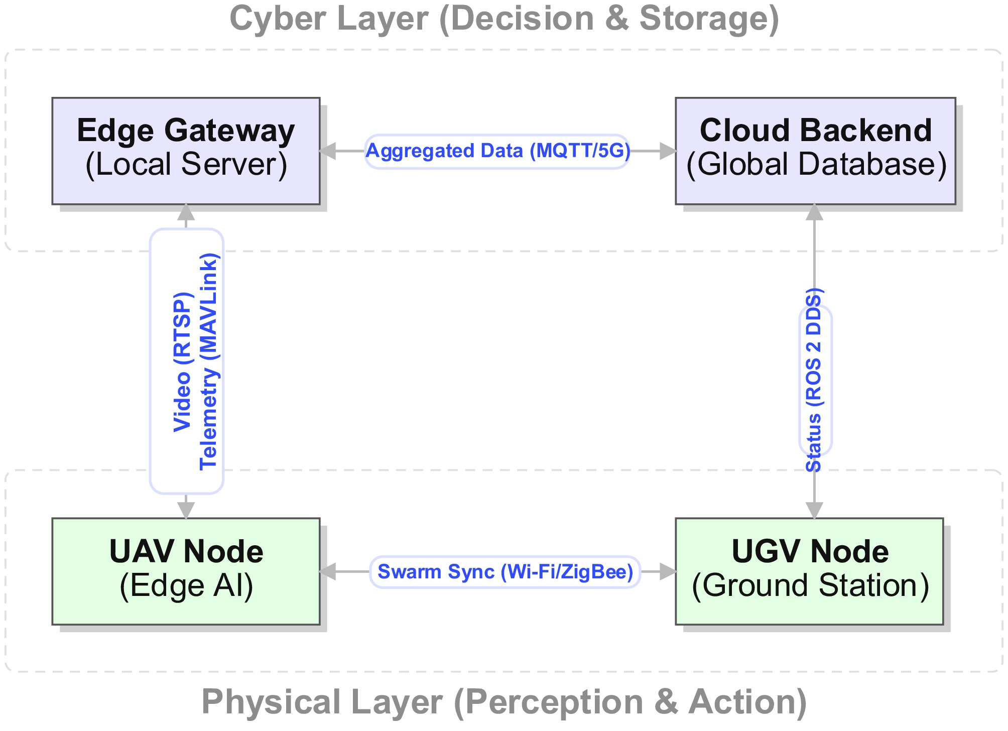
Figure 3.
Cyber–physical connectivity architecture.
-
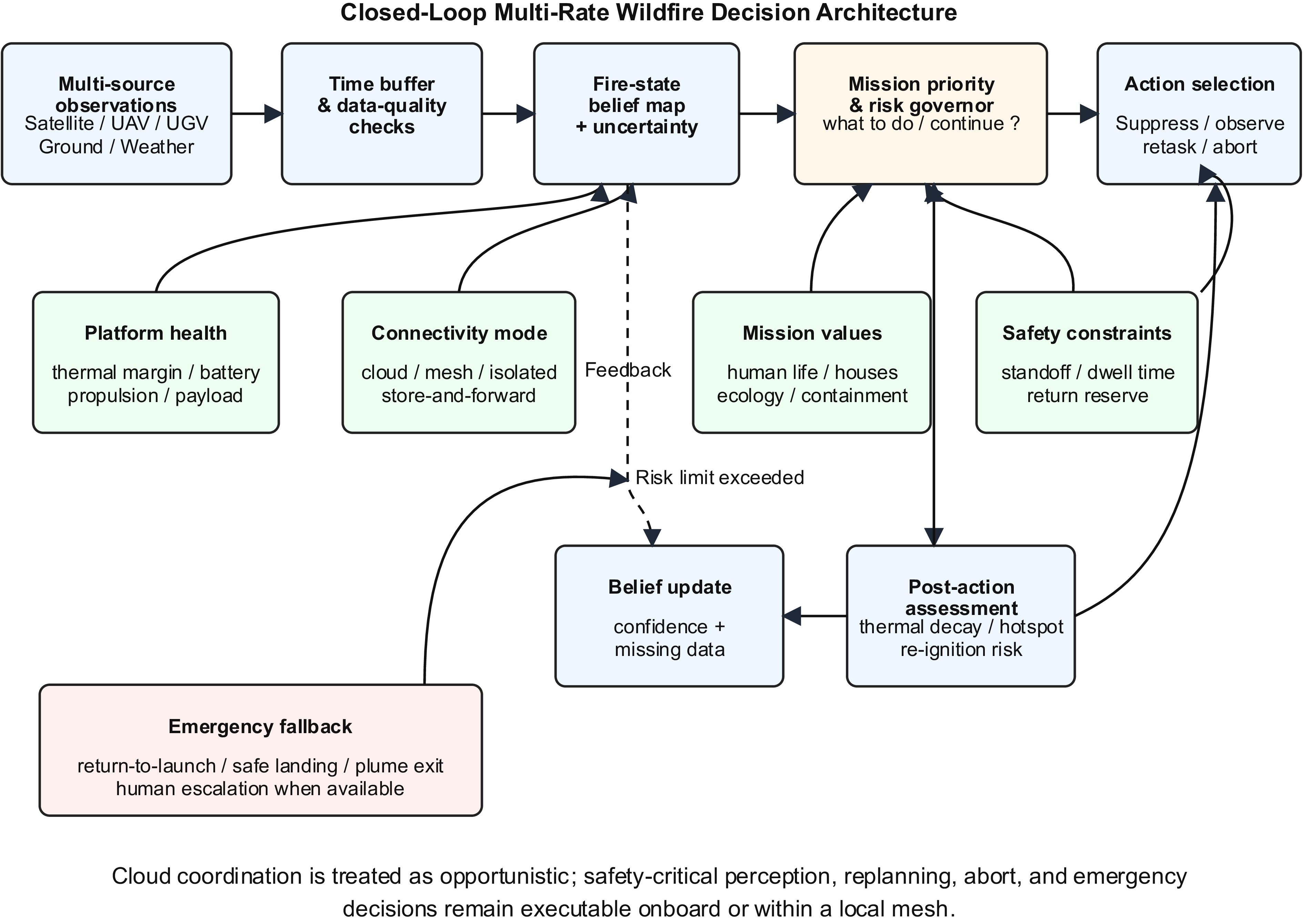
Figure 4.
Closed-loop supervised wildfire decision architecture.
-
Subdomain Key technologies/models Engineering trade-offs Ref. Sensing Optical (RGB) Sony RX1R; Zenmuse H20; GoPro; 4K global-shutter cameras ⊕ High spatial resolution (< 1 cm/px)
⊖ Ineffective in smoke and at night[43,44] Thermal (infrared) FLIR Vue Pro R; Tau 2; Zenmuse XT2 (LWIR) ⊕ Smoke penetration in the 8–14-µm LWIR window
⊖ Thermal crossover and lower spatial resolution[45,46] LiDAR Velodyne VLP-16; Livox Mid-40; Ouster OS1 ⊕ Precise three-dimensional (3D) fuel/structure mapping
⊖ Beam scattering in ash/smoke and high payload cost[47,48] Multispectral MicaSense RedEdge; Parrot Sequoia; normalized difference vegetation index (NDVI)/fuel-state sensing ⊕ Vegetation stress and fuel–moisture analysis
⊖ High computational and calibration payload[49,50] Internet of Things (IoT)/gas BME680 carbon monoxide/volatile organic compound sensing; temperature/humidity nodes; long-range wide-area networks ⊕ Preignition and smoldering detection
⊖ Sparse spatial resolution and drift sensitivity[51,52] AI and processing CNN detectors YOLOv8; EfficientDet; Faster R-CNN ⊕ Low inference latency on embedded edge devices
⊖ False positives under clouds, haze, and hard negatives[53,54] Transformers ViT; Swin transformer; DeTR ⊕ Global contextual awareness
⊖ High power draw and token-level computation cost[26,55] Segmentation U-Net; DeepLabV3+; Mask R-CNN ⊕ Pixel-level area and perimeter estimation
⊖ Slow inference for high-resolution frames[27,56] Smoke models DarkDarkNet; 3D-CNN; motion features ⊕ Early warning potential
⊖ Confusion with fog, steam, and low-contrast clouds[28,57] Edge hardware NVIDIA Jetson Orin/NX; Raspberry Pi 4; FPGA accelerators ⊕ Onboard inference and autonomous operation
⊖ Energy, memory, and thermal throttling constraints[4,58] Fusion Early fusion at pixel/feature level; late fusion at decision level ⊕ Cross-sensor reliability and uncertainty reduction
⊖ Calibration, synchronization, and arbitration complexity[29,59] Platforms Multirotor DJI Matrice 300; custom quadrotors ⊕ Vertical takeoff and landing (VTOL), agility, and static hover
⊖ Limited endurance under continuous flight[30,31] Fixed-wing eBee X; Wingtra VTOL; solar UAVs ⊕ Large area coverage
⊖ Cannot hover or verify a spot without loitering trade-offs[32,33] Ground (UGV) Husky; Summit-XL; firefighting tanks ⊕ High payload capacity and mission duration
⊖ Terrain-related mobility constraints[34,35] Hybrid Morphing TQTV; amphibious or mode-switching platforms ⊕ Mode-switching persistence
⊖ Mechanical complexity and reliability burden[36] Autonomy Localization GNSS/real-time kinematic (RTK); visual odometry; LiDAR–inertial odometry-SAM ⊕ Absolute geolocation and pose estimation
⊖ Signal loss under canopy and smoke-degraded vision[37,58] Planning A*; RRT*; artificial potential fields ⊕ Dynamic obstacle avoidance and replanning
⊖ Computing overhead and risk of local minima[38,60] Swarm Leader–follower control; mesh networking; multi-UAV cooperation ⊕ Scalability and redundancy
⊖ Bandwidth saturation and coordination complexity[34,61] * Note: ⊕ = advantage, ⊖ = disadvantage. RRT*: Rapidly-exploring Random Tree Star (an optimized sampling-based path planner); FPGA: Field Programmable Gate Array; TQTV: Transformable Quadcopter-to-Terrain-Vehicle; SAM: Smoothing and Mapping; A*: A-Star Algorithm (a graph-based search algorithm used for dynamic path planning). Table 1.
Technology landscape matrix.
-
Failure mechanism Physical cause Observed effect Required countermeasure Ref. Thermal crossover High ambient temperature, sun-heated soil/rock/metal, reduced contrast with the flame background Nonfire hot surfaces resemble ignition points; fixed thresholds fail Adaptive background normalization; temporal change detection; hard-negative training [7,9,11,72,78,88] Emissivity and reflection bias Different materials emit and reflect LWIR/MWIR radiation differently Apparent temperature differs from physical temperature; reflective objects create false hotspots Radiometric calibration; material-aware priors; RGB/SWIR/LWIR fusion [7,72,88] Smoke, ash, and turbulence Particulate attenuation, scattering, hot gases, convective motion Blurred boundaries, reduced contrast, unstable apparent object shapes Multiframe filtering; plume motion analysis; uncertainty-aware detection [7,11,68,78] Sensor contamination and heat stress Dust/ash deposition on optics, vibration, radiative heat flux, electronics heating Loss of sharpness, calibration drift, thermal throttling, intermittent detections Ruggedized enclosures; lens protection; thermal management; field reliability tests [9−11,68] Contextual ambiguity Hot engines, campfires, industrial sources, sun glint, fog/cloud/smoke-like distractors High false positives despite high benchmark mAP Geospatial context, fuel maps, gas/particulate matter sensors, meteorological constraints [3,7,8,78,89] Calibration drift and sensor aging MQ/metal oxide baseline shift, humidity/temperature cycling, microbolometer gain/offset drift, nonuniform pixel response Drifting thresholds, fixed-pattern noise, false alarms, missed detections, and inconsistent thermal readings during long deployment Drift-aware baseline tracking; periodic clean-air/blackbody checks; nonuniformity correction; redundant sensor voting; diagnostic downweighting [73,74] Table 2.
Wildfire sensing failure mechanisms.
-
Operating zone Dominant thermal stress Compute/autonomy policy Allowed behavior Ref. Monitoring/far field Ambient plus onboard electronics' heat Full perception stack, mapping, logging, and normal communication Wide-area surveillance, hotspot tracking, and cloud synchronization [8,10,91,96] Warm approach Increasing radiative and convective load Optimized model, reduced streaming, active thermal monitoring Fire confirmation, local replanning, short approach windows [9−11,91,96] Hot standoff High external heat plus peak onboard computation Low-power inference, safety supervisor priority, strict dwell timer Suppression drop, rapid reassessment, immediate exit corridor [9−11] Critical/overload Thermal runaway risk for SoC, battery, or enclosure Noncritical tasks disabled; abort logic dominates Retreat, return to base, emergency landing, or handoff to another platform [9−11] Table 3.
Thermal operating zones for edge autonomy.
-
Observation source Temporal behavior Architectural role Primary integration risk Ref. Satellite thermal hotspots Tens of minutes to hours; delayed products Wide-area situational awareness; regional correction Late evidence, coarse pixels, cloud/smoke contamination [8,70,104] UAV-based RGB/LWIR detection Frame- to second-scale; mission dependent Rapid verification, hotspot localization, suppression assessment Motion blur, smoke occlusion, battery-limited coverage [7,88,89] UGV/LiDAR/local payloads Second-scale Near-ground mapping, local obstacle/fuel assessment Terrain constraints, ash/dust ghost returns [7,78,105] Ground sensor nodes Seconds to minutes Early local anomaly detection and persistence checking Sparse coverage, high sensitivity to false positives [51,52,57,106] Meteorological feeds Minutes to hours Predicting the fire's spread and risk-weighted planning Forecast uncertainty and microclimate mismatch [7,65,66] Table 4.
Multirate observation streams.
-
Navigation modality Smoke penetration Canopy penetration Comp. load Primary failure mode GNSS
(GPS/Galileo)Unaffected
(RF waves penetrate)Blocked
(multipath signal)Negligible Loss of locking under dense trees Visual SLAM
(RGB)Fails
(Tyndall scattering)Variable
(needs texture)High
(feature matching)White-out in smoke/motion blur Thermal SLAM
(LWIR)High
(8–14-µm window)Medium
(leaf occlusions)Medium Thermal crossover (uniform heat) LiDAR SLAM
(LIO)Wavelength dependent*
(905 nm vs 1,550 nm)High
(multiecho return)Very high
(3D registration)Ghost obstacles from ash particles * Note: 1,550-nm LiDAR penetrates moderate smoke significantly better than 905-nm LiDAR because of reduced particulate absorption. Table 5.
Navigation modality trade-offs.
-
Technology/scenario Early ignition Active crown fire Smoldering Night operation RGB camera High
(smoke-free)Low
(smoke occlusion)Low
(ash blending)None
(requires light)Thermal (LWIR) Medium
(range limits)High
(penetration)High
(hotspot detection)High
(passive infrared)Satellite (LEO) Low
(spatial resolution)High
(macro-view)Medium
(revisit time)Medium
(swath dependent)Hybrid UAV–UGV High
(rapid response)Medium
(turbulence)High
(Endurance)High
(sensor fusion)Table 6.
Operational suitability matrix.
-
Integration challenge Example failure Operational consequence Architectural countermeasure Ref. Multirate observations Satellite evidence is delayed when UAV/ground detections are near real-time Stale or duplicated incident state Timestamped buffers, observation age-based weighting, multirate filters [7,65,70,102,104,105] Missing data UAV loses link or thermal camera is saturated Planner acts on incomplete evidence Uncertainty expansion, re-observation requests, fall back on local autonomy [7,9−11,89] Sensor conflict Thermal positive, RGB negative, or LiDAR–GNSS disagreement False alarm, missed fire, or wrong target coordinates Dynamic reliability scoring and arbitration rules [7,78,89,105] GNSS drift Canopy or terrain multipath shifts the fire's coordinates The suppression drop misses the target LIO/VIO correction, uncertainty ellipses, target confirmation pass [7,45,69,78] Communication dropout Edge and cloud maps diverge Inconsistent common operating picture Local decision authority with delayed synchronization [7,8,65,89] No suppression feedback Suppressant drop fails or reignition begins Open-loop mission termination despite an active risk Post-action thermal/RGB reassessment and feedback-driven replanning [106,114−116] Overconfident AI High mAP model fails under smoke, glare, or hot background clutter Unsafe autonomous action Uncertainty-aware inference and hard-negative validation [3,6,7,88] Table 7.
Integration failure modes and countermeasures.
-
Degradation trigger System-level risk Required architectural response Ref. Cellular/5G/cloud loss Global coordination and model offloading unavailable Switch to local mesh or isolated onboard replanning; store-and-forward synchronization [7,8,65,89] Edge gateway loss Swarm desynchronization and inconsistent fire maps Exchange compact belief-state summaries among nearby UAV/UGV nodes [53,89,105,116] GNSS drift plus link loss Incorrect fire coordinates and unsafe approach Downweight GNSS; rely on LIO/VIO where available; increase uncertainty and retreat if localization confidence falls [7,45,78] Rising GPU/SoC temperature Inference latency increases through throttling Reduce the model's size, frame rate, and noncritical analytics; prioritize safety supervisor [10,91,96] External flame radiation/plume heat Rapid reduction in the thermal margin Enforce the standoff zone, dwell time, post-drop exit path, and thermal abort threshold [9,11] Battery or enclosure overheating Power loss or hardware damage Abort suppression, preserve reserve energy, and transfer the task to another platform if available [9−11] Table 8.
Degradation modes and architectural responses.
-
Decision layer Question answered Wildfire example Governance or emergency response Ref. Autonomy definition and authority boundary What level of decision authority is allowed? Differentiate teleoperation, supervised autonomy, and independent mission decisions. Specify the human interaction threshold, the permitted action set, and when escalation is mandatory. [12,14] Execution automation How is a command executed? Follow waypoints, stabilize hover, or perform a drop command. Low-level controllers execute tasks only within verified health and safety limits; an actuator anomaly triggers abort logic. [58,117,118] Perception and localization autonomy What is observed and where is it? Detect fire/smoke, estimate hotspots' location, or navigate under GNSS loss. Use confidence thresholds, re-observation, sensor fallback, and uncertainty expansion when evidence is weak or conflicting. [4,72,88,117] Mission-priority arbitration What should be done first? Select one ignition point among several when the battery or suppressant payload is insufficient. Rank tasks by expected risk reduction, feasibility of suppression, opportunity cost, and the availability of other assets. [13,106,115,116] Risk governor and platform survival Should the task continue? Reject a short path that crosses a high-temperature plume or leaves no return reserve. Apply hard constraints on standoff, dwell time, thermal margin, battery reserves, turbulence, and link state. [9−11] Degraded and isolated autonomy What if cloud or mesh support is lost? Continue local monitoring or suppress only if the onboard belief and return reserve remain valid. Maintain an onboard/local belief map, perform conservative replanning, store data for later synchronization, or retreat. [8,10,60,119] Emergency and fail-safe autonomy What if severe failure occurs? Rotor faults, smoke-blinded vision, battery overheating, or total navigation loss. Execute a return to launch, controlled safe landing, plume exit, mission abort, or human handoff instead of ordinary replanning. [14,117,118,120] Table 9.
Autonomy decision functions and fallback behavior.
-
Level Validation setting Typical strength Main limitation Operational confidence Ref. 1 Synthetic or web-scraped images Low-cost large-scale pretraining and rapid benchmarking No real sensor physics; severe domain gaps; weak negative coverage Very low [3,7,41,94,121] 2 Laboratory flame/smoke experiments Repeatable conditions and controlled labels Limited radiative flux, smoke dynamics, wind, clutter, and platform motion Low [3,7,78] 3 Controlled outdoor or prescribed burns More realistic illumination, wind, and smoke than laboratory scenes Scale and chaos remain constrained; safety protocols simplify the scene Medium [7,68,88,106] 4 Short-duration UAV/UGV field trials near fire lines Captures platform vibration, latency, geolocation, and partial smoke effects Often short, site-specific, and not statistically representative Medium–high [7,53,68,89] 5 Multiseason operational wildfire deployment Includes uncontrolled smoke, heat, wind, terrain, communications, and maintenance effects Expensive, hazardous, and difficult to standardize High [7−11,68] Table 10.
Methodological reliability framework.
Figures
(4)
Tables
(10)