













-
Over the past half-century, the forest cover in China has increased from less than 10% to over 25% of the total land area[1]. This remarkable large-scale project has not only effectively combated land desertification and dust storm hazards but has also become one of the world's largest new carbon sinks, thereby contributing to mitigating global climate change.[2]. However, its hydrological impacts remain controversial. Recently, concerns regarding potential disruptions to China's water cycle have been widely discussed in academic literature and media reports. These arguments can be summarized as three main points:
(1) Afforestation overconsumes scarce water resources in arid regions.
Some studies suggest that large-scale afforestation projects in the arid and semi-arid regions of China, such as the 'Three-North Shelterbelt Forest Program', the 'Grain for Green Program', and the 'Taklimakan Desert Perimeter Protection Project', may improve the local environment while consuming substantial amounts of groundwater[3]. Consequently, long-term groundwater depletion could potentially trigger vegetation dieback and subsequent reversion to desert[4].
(2) Afforestation altered the redistribution of water vapor and caused declines in available water in agricultural regions.
Research by An et al. indicates that large-scale afforestation in China has led to a decreasing trend in available water resources, which were quantified using precipitation minus evapotranspiration (P – ET) as a proxy, with an annual reduction of 0.46 mm[5]. This study also noted that water taken up and subsequently transpired by trees appeared to shift toward the Tibetan Plateau, a region with minimal industry and the lowest population density in China[5]. While these findings provide valuable insights into atmospheric moisture recycling, interpreting P – ET as the sole indicator of available water resources may oversimplify the hydrological impacts of large-scale afforestation in China.
(3) Deserts cannot be eliminated, and combating deserts through afforestation is a reckless act that disrupts natural ecosystems.
Proponents of this view argue that desertification in arid regions is a natural process. Attempts to afforest natural deserts in arid regions may conflict with baseline ecosystem functions and disrupt natural ecological balances, requiring large-scale groundwater extraction or trans-regional water diversion, which could increase the risk of broader environmental degradation[6−9].
While these concerns highlight critical hydrological trade-offs, a comprehensive evaluation incorporating long-term field observations and evolving management paradigms suggests a more nuanced reality.
HTML
-
Over the past century, afforestation strategies in China have transitioned from historically extensive planting regimes toward scientifically guided ecological models. China's current approach emphasizes 'determining greenery based on water', meaning that afforestation design—including spatial scale, species selection, and planting density—is strictly calibrated against local water resource carrying capacities[10−12]. In arid regions, afforestation species selection has shifted from water-intensive tall trees toward drought-resistant native shrubs and grasses, with low-coverage and mixed shrub–grass configurations[13−15]. Furthermore, advanced engineering technologies—including high-efficiency water-retaining soil additives, new straw checkerboard sand fixation techniques, efficient mycorrhizal composite technologies, and precise quantitative forestry systems—have been systematically deployed[16−19]. These scientific models have been proven highly effective in stabilizing sand dunes, preserving soil moisture, and improving the regional environment. Consequently, challenges associated with high-density monocultures, often termed 'green deserts', have been increasingly addressed by contemporary adaptive management frameworks over the past two decades.
Additionally, evaluating vegetation water use solely as net consumption represents a static perspective that omits systemic ecological feedbacks. Research on the water cycle in planted forests must consider not only the trees themselves but also the water cycling and balance of the entire ecosystem. In fact, forests, together with understory shrubs and grasses, provide critical canopy shade and reduce near-surface temperatures and wind speeds, thereby greatly reducing nonproductive evaporation of soil moisture[20]. Tree roots help loosen the soil, substantially increasing soil porosity and organic matter content. This allows the soil to function like a sponge, enhancing its water retention capacity[21,22]. These processes facilitate the infiltration and storage of precipitation within the soil profile, reducing surface runoff and soil erosion. This mechanism functions effectively as a 'soil reservoir', contributing to the temporal and spatial redistribution of water resources by sustaining baseflows during dry seasons and enhancing deep soil water storage[23,24]. In summary, while forests 'consume' water, they also contribute to 'savings' (by suppressing soil evaporation) and 'storage' (by enhancing infiltration and water retention). Under appropriate management, improvements in soil water conservation and infiltration may partly offset the increased transpiration associated with afforestation at local and regional scales[25−29]. From a long-term and holistic perspective, afforestation may contribute to improved regional water resource utilization efficiency and ecological stability, supporting water resource management and ecological investment[30,31].
Furthermore, afforestation in many arid regions of China, such as the Yellow River Basin, primarily relies on surface-water resources rather than groundwater[32]. In these regions, vegetation restoration is largely based on grasses and shrubs. Most of the so-called afforestation efforts involve shrubs whose water consumption is even lower than that of common herbaceous plants, thereby achieving favorable ecosystem services with relatively low water consumption[33,34]. Moreover, these newly afforested areas are generally not located in the cores of natural deserts but rather in areas impacted by anthropogenic disturbance, and are therefore less likely to significantly disrupt the local water cycle.
-
Although some studies suggest that water vapor released through vegetation transpiration is shifting toward the sparsely populated Tibetan Plateau, this does not mean that the water vapor will remain there[35−38]. In fact, the Tibetan Plateau serves as the principal headwater source for major river systems, including the Yangtze, Yellow, and Lancang Rivers, and is known as the 'Water Tower of Asia'[39,40]. Moisture transported toward the Tibetan Plateau may contribute to precipitation and cryospheric storage, while subsequent snow and glacier melt can contribute to river runoff flowing from the plateau[38,41,42]. In addition, over the past 60 years, annual precipitation on the Qinghai–Tibet Plateau has shown an increasing trend of approximately 3.8–12.0 mm per decade, and most of this precipitation flows down from the plateau in the form of runoff[39,43]. In summary, part of the increased water vapor over the Qinghai–Tibet Plateau replenishes glacial meltwater, while another part turns into precipitation. Together, these observations are consistent with the hypothesis that enhanced moisture recycling may contribute to increased runoff from the Tibetan Plateau, although the quantitative contribution of afforestation relative to climate change remains to be determined[44]. Precipitation minus evapotranspiration (P − ET) can serve as a useful indicator of climatic water balance and land-atmosphere moisture surplus[5]. However, P − ET is fundamentally a local water-balance closure metric rather than a basin-scale or regional water-resource budget. Therefore, it does not explicitly account for lateral runoff, trans-regional river inflows and outflows, groundwater exchange, cryospheric storage changes, reservoir regulation, or human water withdrawals[5]. As a result, interpreting P − ET as the sole indicator of available water resources may underestimate hydrological connectivity, particularly in regions where water supply depends heavily on runoff originating from upstream basins. In other words, at the continental scale, interpreting P − ET as the sole residual term for water availability can be misleading, particularly in water-deficient arid zones. This is because many rivers in China are trans-regional, and the ecological water consumption in arid zones is primarily sustained by water transferred from rivers originating in other regions. When runoff and trans-regional water transfers are considered, previous assessments based solely on P − ET may not fully represent regional water availability. This interpretation is consistent with recent hydrological studies, although comprehensive basin-scale water-balance analyses remain necessary. Recent hydrological studies suggest increasing runoff and improved regional water availability in parts of northwestern China under recent climatic conditions[45,46]. In particular, it is important to note that annual evapotranspiration far exceeds precipitation across large areas of northwestern China[47−49]. The actual water supply for ecosystems, cities, and agriculture in these regions relies heavily on runoff, making runoff a major determinant of regional water availability[50−52]. Minor changes in precipitation and evapotranspiration may therefore have relatively limited impacts[53]. In other words, as long as evapotranspiration continues to far exceed precipitation in northwestern China, using precipitation minus evapotranspiration to represent available water resources is not very meaningful. Instead, changes in runoff may be more informative. Furthermore, afforestation-induced increases in evapotranspiration occur primarily during the growing season and are relatively minor compared to the broader impacts of global climate change. Most studies indicate that both Northwest China and the Tibetan Plateau are experiencing widespread increases in runoff due to global climate change[54], and the frequent occurrence of meteorological events such as typhoons has further intensified this trend[55]. These impacts may be substantially greater than the climatic effects attributable to afforestation. Therefore, we hypothesize that afforestation-induced moisture recycling may contribute to regional hydrological redistribution. However, the relative contributions of afforestation, climate change, cryospheric processes, and water management require future quantitative attribution. The increase in water availability associated with recent climatic changes may provide favorable conditions for ecological engineering projects such as afforestation. Declines in available water within the Haihe and Liaohe River basins, whose headwaters originate outside the Tibetan Plateau, are primarily attributed to intensive anthropogenic water extraction rather than afforestation activities[46]. Nevertheless, ongoing regional water-diversion and conservation initiatives may facilitate groundwater recovery and contribute to hydrological stabilization[56].
To provide a descriptive background on long-term national water-resource variability during the major afforestation period, we compiled annual total water resources in China from 1956 to 2024 using national water-resource statistics and the China Water Resources Bulletins and applied the Mann–Kendall test to detect long-term trends and possible abrupt changes (Fig. 1). The results show no significant abrupt decline in China's total water resources over this period (p > 0.05). This is particularly relevant given that large-scale ecological engineering accelerated with the launch of the Three-North Shelterbelt Program in 1978[57,58], and further intensified following the implementation of the Grain for Green Program in the late 1990s[59,60]. Although this descriptive analysis cannot attribute hydrological changes specifically to afforestation, as national water resources are simultaneously influenced by precipitation variability, climate warming, cryospheric change, land-use change, and water management, no statistically significant abrupt decline (p > 0.05) was detected during the major afforestation period.
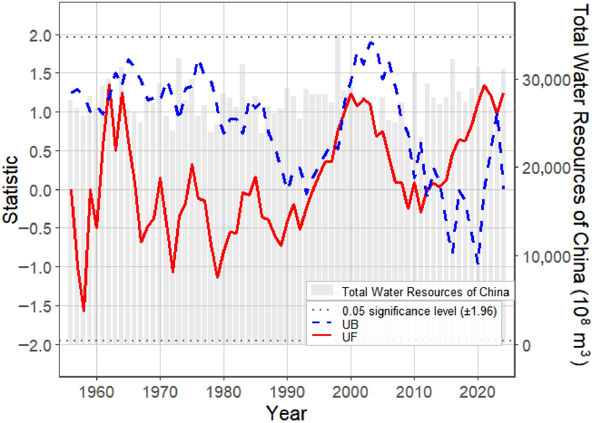
Figure 1.
Mann–Kendall mutation test of China's total water resources (1956–2024). Annual total water resources were compiled from the China Water Resources Bulletin and National water-resource statistics. No statistically significant abrupt change points (p > 0.05) were detected after 1978 or the implementation of the Grain-for-Green Program. This figure provides descriptive background on long-term national water-resource variability and should not be interpreted as direct evidence of causal effects of afforestation.
In conclusion, drawing upon multiple lines of evidence, we infer that increased water vapor over the Tibetan Plateau may increase runoff to the arid and semi-arid regions of China, thereby increasing water availability in these areas. These observations are consistent with the hypothesis that afforestation-induced moisture recycling does not necessarily reduce water availability in arid regions and may contribute to regional hydrological redistribution, although further quantitative attribution is needed.
-
The concept of a 'Great Green Wall' reflects a defensive strategy aimed at halting desert encroachment rather than eradicating natural desert ecosystems. Its purpose is to prevent the expansion of deserts, much like the historical Great Wall was built to defend against invasions. Afforestation projects for desertification control in China can be broadly divided into two categories based on their objectives: restoration-oriented and defense-oriented. Restoration-oriented projects aim to restore degraded ecosystems, including the restoration projects in the four major sandy lands and the Grain-for-Green program. Defence-oriented projects are designed to prevent desert encroachment, such as the Three-North Shelterbelt Program and the Taklamakan Desert Perimeter Protection Project.
For instance, the restoration projects in the four major sandy lands are typical examples of restoration-oriented afforestation. While these efforts are occasionally misinterpreted as attempts to transform natural deserts (Fig. 2a), historical and sedimentological evidence indicates that these sandy lands were largely degraded due to intense anthropogenic pressures during the 20th century[61,62]. The changes in NDVI across the four sandy lands from 1990 to 2025 indicate that all of them experienced degradation followed by recovery (Fig. 2b). This observation suggests that the afforestation projects in the four major sandy lands do not represent afforestation of natural deserts, but rather a progressive restoration of the local native vegetation[63]. These projects have substantially increased vegetation cover and ecological quality, while independent hydrological studies have reported an increase in permanent surface-water area in some vegetation-restoration regions and context-dependent changes in soil water content[64,65]. Ultimately, these projects focus on ecological recovery rather than desert transformation[61], essentially representing efforts to 'reclaim lost land'.
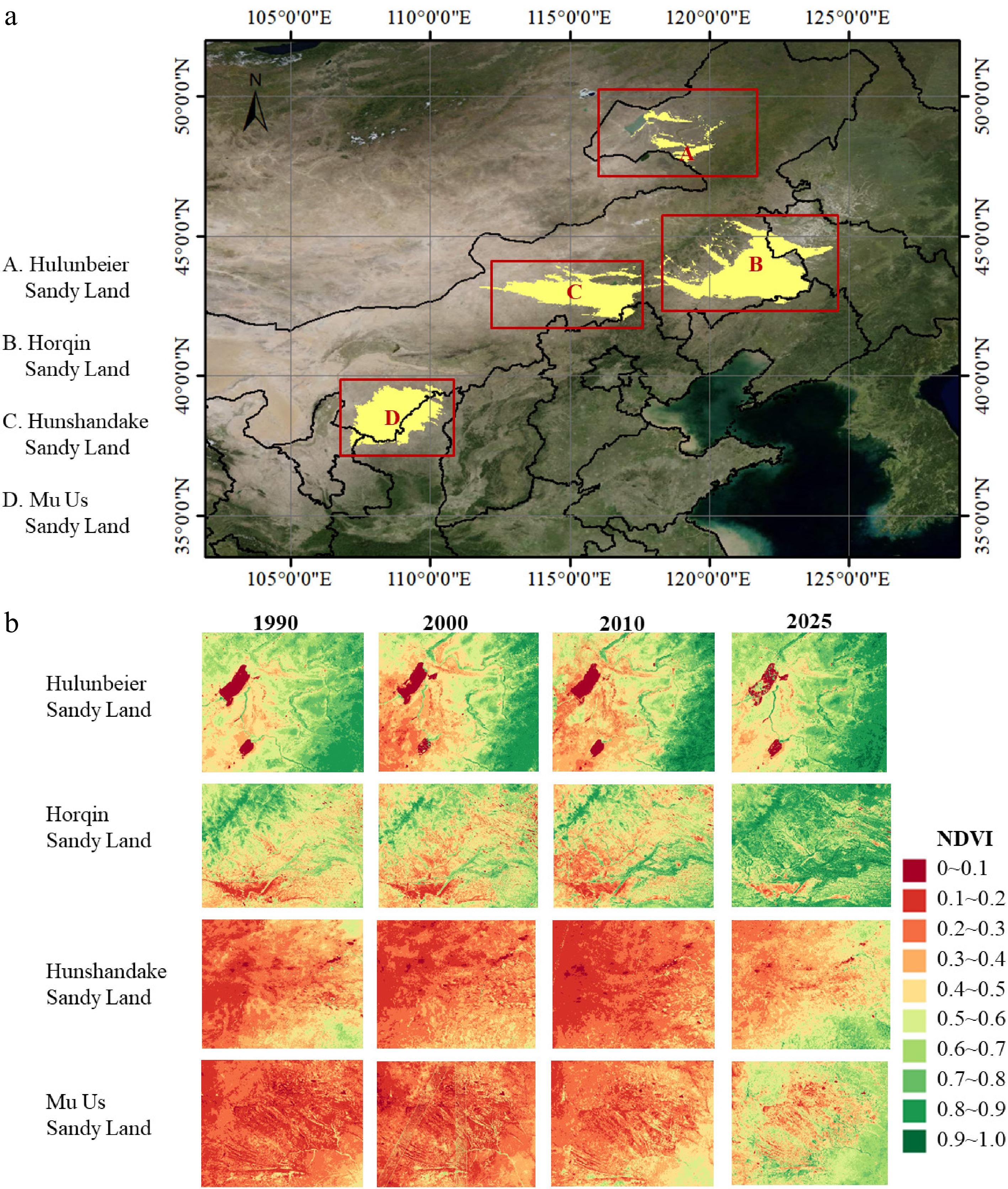
Figure 2.
(a) Locations of China's four major sandy lands and (b) NDVI values for the four sandy lands in 1990, 2000, 2010, and 2025. NDVI was calculated from Landsat surface reflectance products (USGS Collection 2 Tier 1 Level 2, 30 m resolution) using the standard (NIR − Red)/(NIR + Red) formula. For each target year, we used images from May to August and applied the maximum-value composite (MVC) to represent the peak vegetation condition.
The Taklamakan Desert Perimeter Protection Project serves as a typical example of a defense-oriented project. The Taklamakan Desert, the world's largest shifting desert, frequently encroaches upon adjacent forests, grasslands, and farmlands, causing ecological disasters. The 'Taklamakan Desert Perimeter Protection Project' serves as a critical buffer zone, mitigating desertification risk and stabilizing the fragile ecological environment of Xinjiang while minimizing impacts on regional water allocation. Moreover, this project has been shown to enhance carbon storage while maintaining stable water-use efficiency[64]. Additionally, China's advanced forestry engineering technologies should not be underestimated. These new technologies can support the construction and maintenance of these 'Great Green Walls' under existing water-resource conditions.
-
Adopting a macro-scale, long-term perspective across East Asia reveals a significant correlation between the mitigation of regional drought, desertification, and soil erosion and the expansion of managed forests[14,65,66]. During the 20th century, severe human-induced damage led to accelerating soil erosion, persistently high desertification levels, and intensified water cycle instability. Concurrently, regional desertification-control efforts have covered approximately 350,000 km2 between 2005 and 2025, accompanied by substantial improvements in river basins, lake health, and ecological water reserves[67,68]. Recent large-scale remote sensing analyses have shown that China has experienced substantial vegetation greening over the past four decades, contributing to improved ecosystem stability[69,70]. In particular, vegetation restoration in China has increased evapotranspiration and strengthened precipitation recycling, suggesting potential redistribution rather than disruption of the atmospheric water cycle and a possible shift toward a new dynamic equilibrium[70,71]. For instance, on the Loess Plateau, the precipitation recycling ratio increased from 9.16% to 10.18%[72]. Therefore, from a century-long perspective, our findings are consistent with the view that large-scale afforestation in China may not have fundamentally disrupted the water cycle; rather, it could have contributed to a new dynamic equilibrium through enhanced continental-scale evapotranspiration–precipitation feedback and moisture recycling.
From a spatial perspective, the pattern of flooding in southeastern China and drought in the northwest is quite evident. Enhanced transpiration from afforested landscapes has been linked to increased precipitation, and atmospheric moisture tracking has revealed net moisture transport toward the Tibetan Plateau[5]. In contrast, eastern and southern China generally experience hydrologic surpluses due to abundant water resources. Minor increases in evapotranspiration within these humid zones do not significantly affect water availability[73]. Therefore, the increased transport of water vapor toward the Tibetan Plateau is consistent with a large-scale redistribution of water resources[74,75]. This moisture transport could subsequently enhance precipitation and runoff in downwind regions and potentially feed the arid northwestern basins[49]. This water-cycle process may provide two ecological benefits: on the one hand, it appears to accelerate the water cycle, potentially enhancing water cycling within ecosystems[76]; on the other hand, secondary redistribution over the Tibetan Plateau may contribute to regional redistribution of water availability[37,76−78]. Furthermore, the vast expanse of newly planted forests in China has become a massive carbon sink that contributes to climate change mitigation. This could increase the adaptive capacity of ecosystems to hydroclimatic changes, thereby helping to reduce the adverse impacts of water cycle alterations caused by climate change.
In summary, although China's water cycle faces severe challenges from global climate change, whether large-scale afforestation is a primary contributor to the observed hydrological disruptions remains unclear, as multiple factors operate concurrently. Afforestation may generate both ecohydrological benefits and hydrological trade-offs, and their overall effects depend on regional hydroclimatic conditions, management practices, and spatial scale (Fig. 3). Therefore, rather than viewing large-scale afforestation in China as disrupting the water cycle, future research should focus on how to maximize its positive ecohydrological effects while minimizing potential hydrological trade-offs.
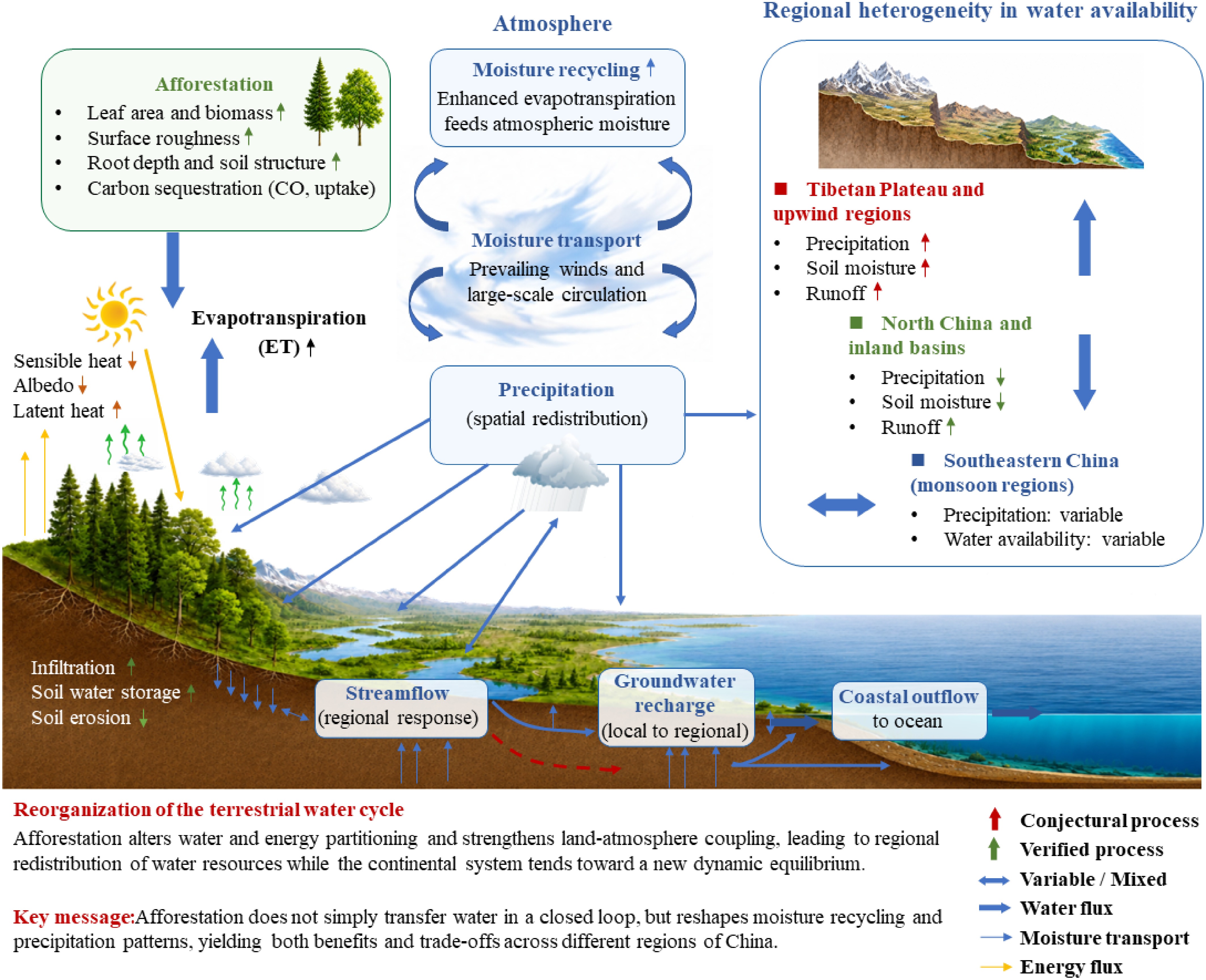
Figure 3.
Conceptual synthesis illustrating hypothesized pathways through which afforestation may influence terrestrial water cycling across China, via changes in moisture recycling, evapotranspiration, and hydrological redistribution. At local scales, there is evidence that afforestation can increase evapotranspiration, enhance land-atmosphere coupling, and promote infiltration and groundwater recharge. However, the broader regional-scale linkages, including changes in the spatial redistribution of precipitation and runoff and a potential shift toward a new dynamic equilibrium, remain hypothetical and require further quantitative attribution. These processes may contribute to regional heterogeneity in water availability, while a shift toward a new dynamic equilibrium remains hypothetical. Abbreviations: ET, evapotranspiration. Symbols: solid arrows indicate evidence-supported pathways; dashed arrows indicate hypothesized pathways that require quantitative attribution.
It is well established that large-scale afforestation in water-limited regions can reduce streamflow and deplete soil water storage, particularly under early implementation schemes characterized by high planting density and limited consideration of regional water constraints[79−81]. These studies provide a critical foundation for understanding forest-water trade-offs and highlight that vegetation restoration is not universally beneficial across all hydrological contexts.
However, afforestation practices have evolved considerably in China over the past two decades. Current strategies increasingly adopt water-resource-based planning frameworks, emphasizing 'determining greening based on water availability', the selection of drought-resistant native species, and the use of mixed shrub-grass systems in arid and semi-arid regions. A more nature-friendly approach to rewilding has also begun to be adopted[82]. These adjustments may reduce ecosystem water demand and improve compatibility between vegetation restoration and regional water budgets. Therefore, observed hydrological outcomes of afforestation should be interpreted within a management-era context rather than treated as uniform across time and space.
A synthesis of the available literature suggests that the persistent debate regarding the hydrological impacts of afforestation largely stems from inherent scientific uncertainties and fragmented research scales. These uncertainties arise mainly from two sources: narrow disciplinary perspectives and spatial fragmentation across regional scales. The narrowness of these research perspectives refers to the tendency of scholars from different disciplines to draw relatively narrow conclusions based solely on their own disciplinary viewpoints. For example, meteorologists may focus primarily on atmospheric moisture, hydrologists on surface water, and geologists on groundwater. Spatial fragmentation across regions and scales refers to the common practice of studying different regions and scales in isolation. For instance, studies on the middle and lower reaches of the Yellow River often ignore the upper reaches; research on local soil water frequently overlooks the broader water cycle; and large-scale hydroclimatic analyses tend to neglect changes in soil water at the local scale. The persistence of these uncertainties may constrain the strategic planning of large-scale forestry initiatives and impede the optimization of their ecological benefits under global change. Therefore, we suggest that future efforts should strengthen the quantification and monitoring of 'multi-scale full-volume water resources' in forests to obtain more accurate information on 'available water resources'. The key to quantifying 'multi-scale integrated water resources' lies in bridging different scales, regions, and research directions. Specifically, interdisciplinary efforts should integrate the quantification of atmospheric water, biological water, surface water, and groundwater into a comprehensive accounting of the entire water cycle. Across different scales, it is essential to establish linkages between local and broader processes to quantitatively assess the overall hydrological functioning of ecosystems. Concurrently, promoting trans-regional data sharing and integration is vital to achieve comprehensive monitoring. These integrated approaches will significantly reduce systematic uncertainties, thereby providing robust scientific guidance for afforestation policies and supporting the optimization of ecosystem service benefits.
Overall, our synthesis indicates that afforestation should not be viewed as either universally beneficial or universally detrimental to regional water resources. Instead, its hydrological consequences depend on interactions among climate, vegetation, management, and spatial scale. These insights support continued, adaptive afforestation guided by multi-scale hydrological monitoring rather than premature dismissal based on incomplete metrics.
-
The authors confirm their contributions to the paper as follows: manuscript drafting: Song W; manuscript review and revising: Lin X, Gao J, Yuan W; funding support: Lin X, Gao J; figure preparation: Wujisi G. All authors reviewed the results and approved the final version of the manuscript.
-
The data used in this study were obtained from publicly available sources. Annual total water-resource data for China from 1956 to 2024, used in Fig. 1, were compiled from national water-resource statistics and the China Water Resources Bulletins. The China Water Resources Bulletins are publicly available through the official information service of the Ministry of Water Resources. The vegetation data used in Fig. 2 were derived from Landsat surface reflectance products (USGS Collection 2 Tier 1 Level 2, 30 m resolution). NDVI was derived from Landsat imagery acquired from May to August for the target years (1990, 2000, 2010, and 2025), and maximum-value composites were generated to represent peak vegetation conditions. Landsat Collection 2 data are publicly accessible through USGS EarthExplorer (www.usgs.gov/landsat-missions/).
-
The authors declare that they have no conflict of interest.
- Copyright: © 2026 by the author(s). Published by Maximum Academic Press, Fayetteville, GA. This article is an open access article distributed under Creative Commons Attribution License (CC BY 4.0), visit https://creativecommons.org/licenses/by/4.0/.
Lin X, Yuan W, Wujisi G, Gao J, Song W. 2026. Reassessing the role of large-scale afforestation in hydrological disruptions in China. Forestry Research 6: e029 doi: 10.48130/forres-0026-0030


|