-
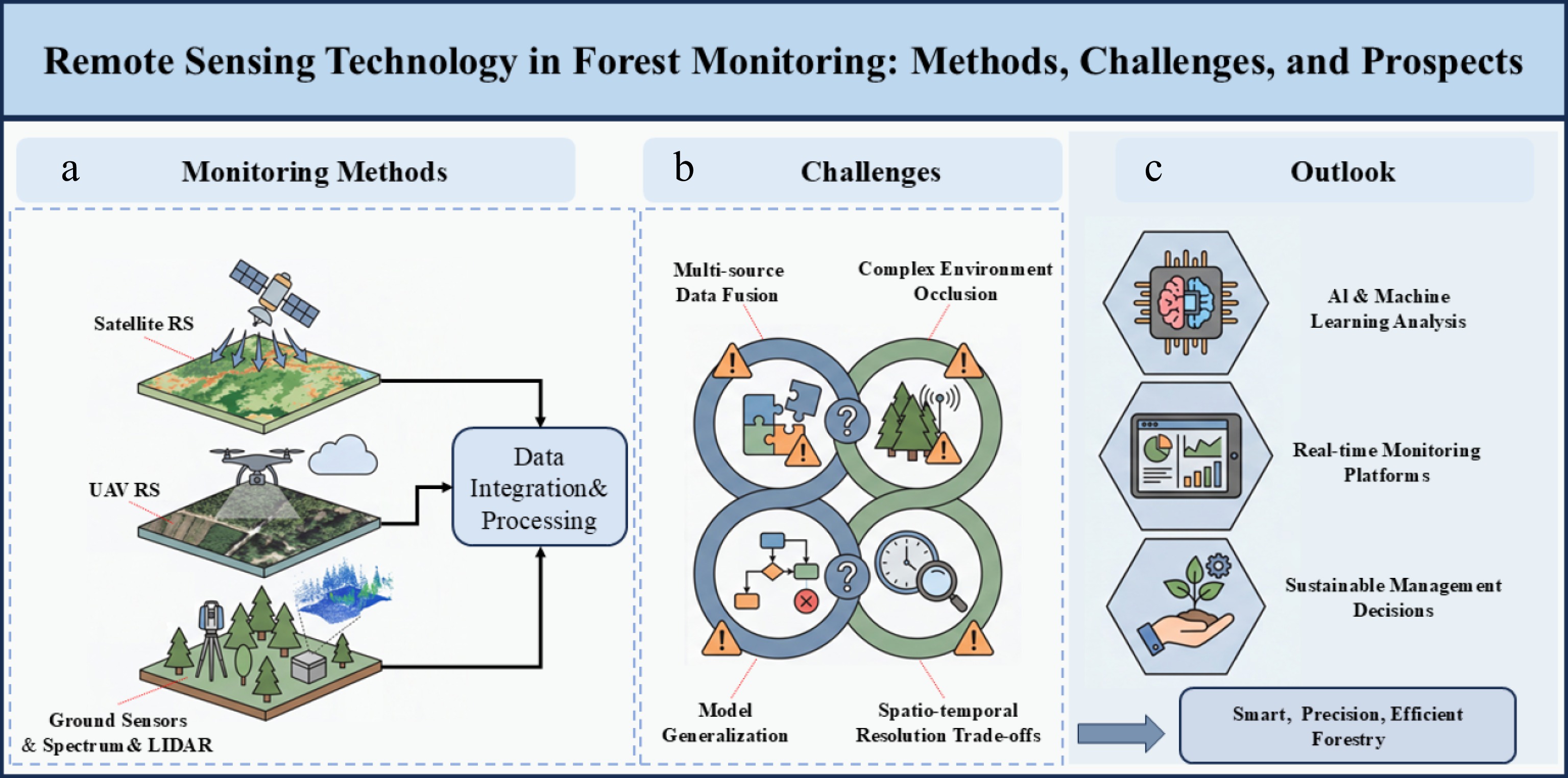
Figure 1.
Remote sensing technology in forest monitoring: methods, challenges, and prospects.
-
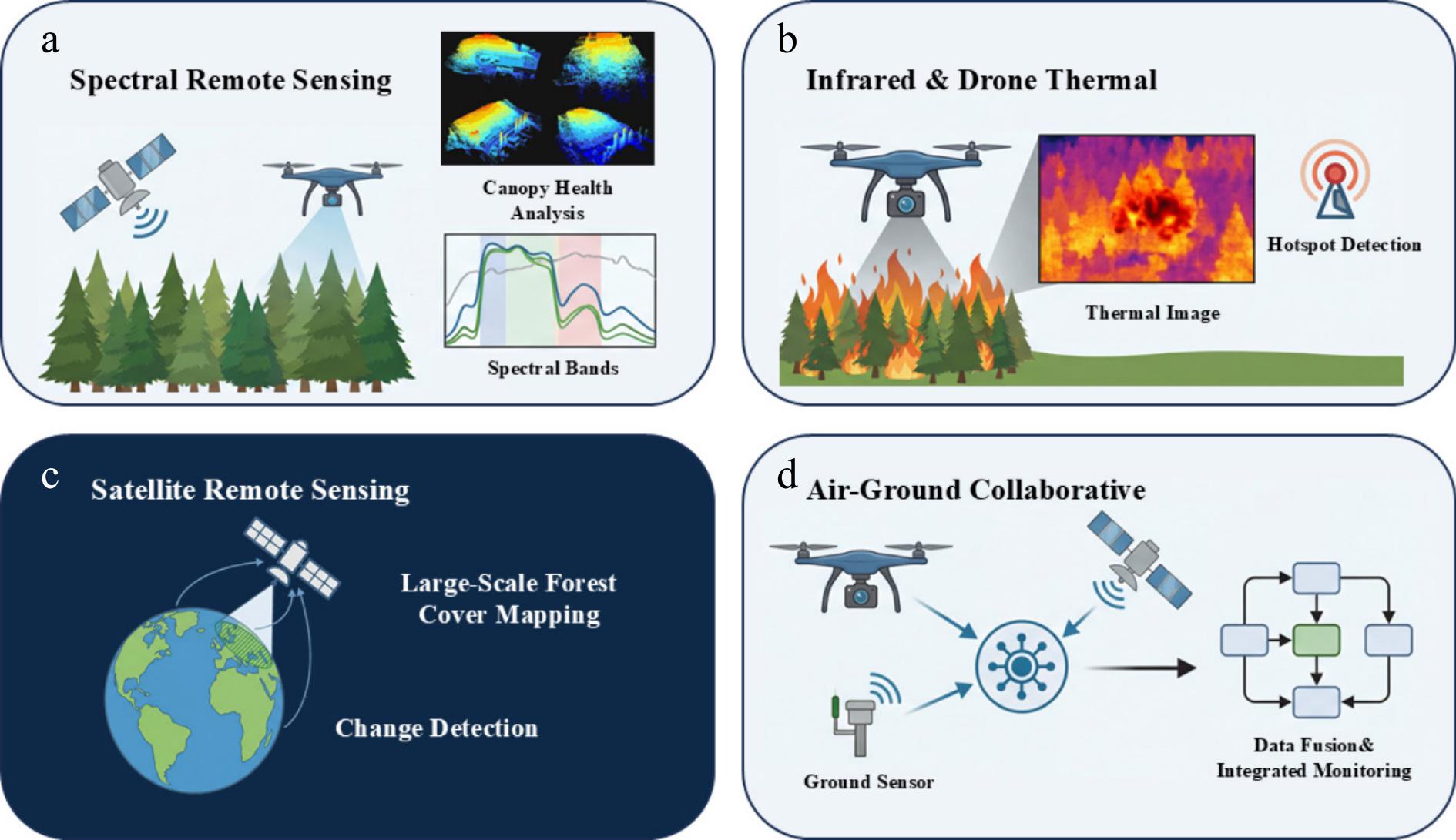
Figure 2.
Remote sensing technologies: (a) spectral remote sensing; (b) infrared and drone thermal; (c) satellite remote sensing; (d) air-ground collaborative.
-
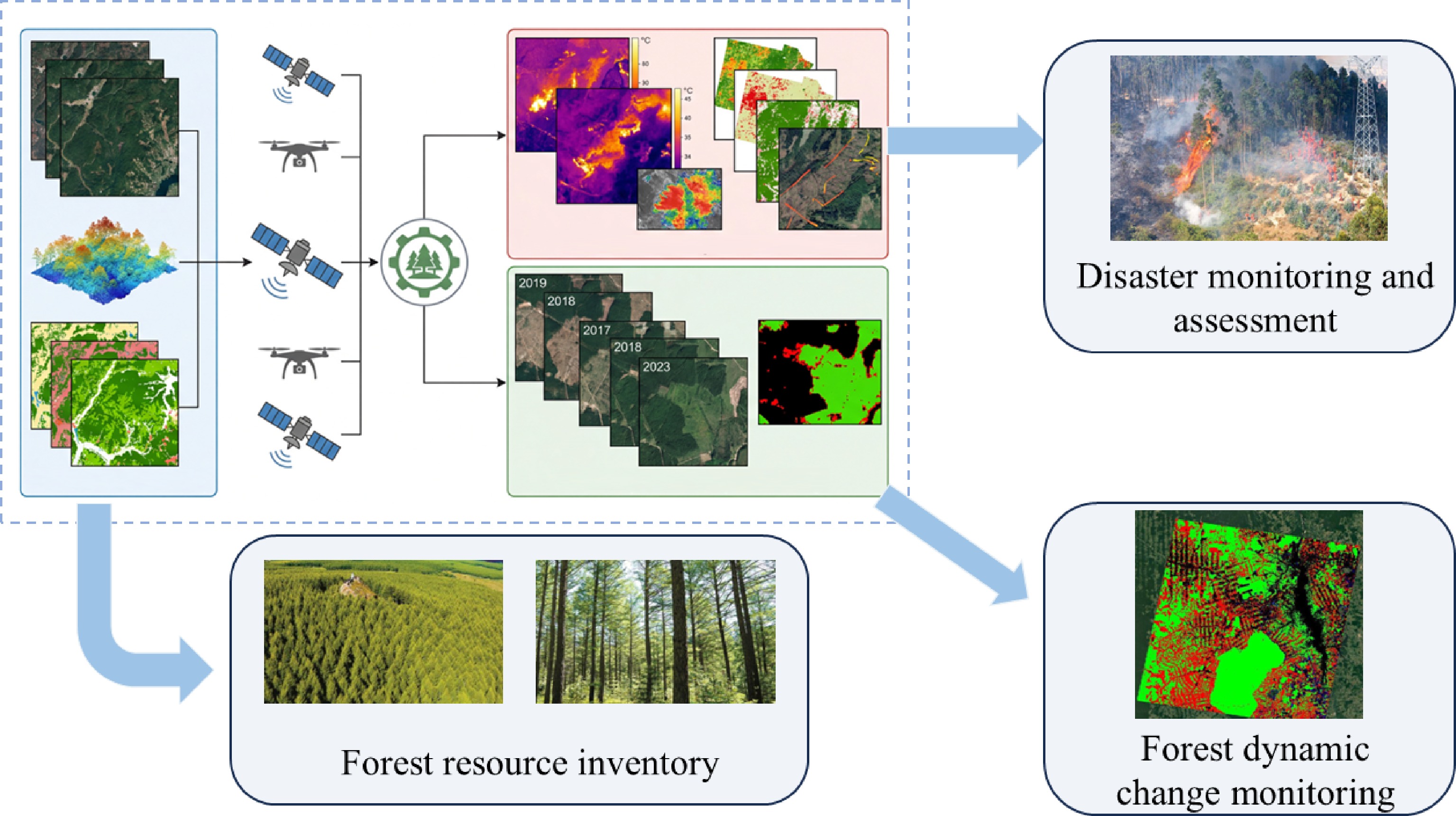
Figure 3.
Specific applications of remote sensing in forests.
-
Period International development context Chinese development context Milestone events Ref. Origin and early stage
(late 19th century–
mid 20th century)Late 19th century: beginning of aerial photography using balloons and aircraft. / / [4] Early 20th century to World War II: maturation of aerial photogrammetry technology; extensive application of visual interpretation in forest surveys
and mapping.1951–1980: dominated by visual interpretation of aerial remote sensing images; establishment of a forest resource survey technology system of 'aerial photography + ground survey' through introduction and digestion, supporting the first national forest resource inventory. / [4,5] Satellite remote sensing development period
(1970s–1990s)1970s: launch of the Landsat series by the United States, providing multispectral data to realize large-scale forest cover monitoring. / Launch of Landsat-1 (1972).
Technical features: multispectral imaging; spatial resolution: 80 m.[4,5] 1980s–1990s: expansion of radar, thermal infrared and other technologies; emergence of high-resolution commercial satellites, promoting refined mapping. 1981–1999: entering the stage of satellite remote sensing development and innovation; introduction of Landsat and other data; first development of remote sensing digital image processing systems for forest resource surveys; application expanded to shelterbelt surveys, wetland, desertification, and disaster monitoring. Launch of SPOT-1 (1986).
Technical features: stereoscopic imaging; spatial resolution:
10–20 m.
Operation of Landsat-7 ETM+ (1999).
Technical features: panchromatic band fusion; spatial resolution: 15–30 m.[4−6] Technological diversification and quantification
(2000s–2010s)2000s–2010s: maturation of LiDAR, hyperspectral, SAR and other technologies, enabling quantitative inversion of forest three-dimensional structure,
biomass, etc./ Completion of global DEM by SRTM (2000).
Technical features: radar interferometry; spatial resolution: 30–90 m.
Launch of GeoEye-1 (2008).
Technical features: sub-meter commercial satellite; spatial resolution range: 0.41 m.[4,5] 2010s–2019: in-depth integration of GIS and remote sensing, forming comprehensive management platforms. 2001–2019: entering the stage of quantitative remote sensing development and comprehensive service platform formation; in-depth research on forward mechanism models of optics, microwave, and LiDAR; breakthrough in quantitative parameter inversion technology; construction of a high-resolution forestry remote sensing comprehensive application service platform to realize operational operation. Launch of Landsat-8 (2013).
Technical features: OLI/TIRS dual sensors; spatial resolution: 15–30 m.
Launch of Sentinel-2A (2015).
Technical features: free high-resolution data; spatial resolution: 10–60 m.
Launch of Gaofen-5 (2018).
Technical features: hyperspectral imaging; spatial resolution: 30 m.[4,5] Current trends
(2020s–present)1. Collaboration between UAV remote sensing and satellites to achieve high-frequency monitoring; 2. AI-driven automatic interpretation and change detection; 3. Global remote sensing data sharing to support forest carbon sink monitoring and sustainable development goals. Deepening of the air-space-ground integrated monitoring network; integration of AI, big data, and remote sensing; serving new functions such as forest and grassland resource management and national park supervision; moving towards in-depth integration of intelligence and operationalization. Launch of Gaofen multi-modal satellite (2020).
Technical features: multi-mode imaging; spatial resolution: 0.5 m.[4,5] Table 1.
Development history of remote sensing in China, and abroad.
-
Technology category Technology subclass Advantages Disadvantages Applicable scenarios Ref. Spectral remote sensing Multispectral remote sensing technology 1. It can acquire reflectance information of ground objects in specific bands such as visible light and near-infrared, and has strong penetration through trees;
2. The vegetation index (NDVI, EVI, etc.) application system is mature, enabling quantitative analysis of forest parameters;
3. Long-term observation data is continuous (such as the Landsat series from 1972 to the present), supporting large-scale dynamic monitoring.1. Low spectral resolution and limited number of bands, resulting in weak capabilities for detailed tree species identification and early stress diagnosis;
2. Highly affected by clouds, fog, and atmospheric conditions, leading to unstable data availability.1. Forest type identification, timber quality and growth status assessment;
2. Forest productivity and phenological monitoring;
3. Estimation of growth parameters such as forest leaf area index (LAI).[8−11] Hyperspectral remote sensing technology 1. High spectral resolution and numerous bands enable the identification of subtle spectral differences in ground features;
2. Red-edge parameters accurately reflect health information such as chlorophyll content and
vegetation stress levels;
3. Monitoring models can be established to predict pest infestation periods and accurately diagnose tree health.1. Large data volume and high redundancy; complex preprocessing and calculation processes; high computational power requirements.
2. High cost; low efficiency in data acquisition and large-scale coverage; difficulty in high-frequency monitoring.1. Precise classification and identification of tree species;
2. Forest health monitoring and early stress diagnosis;
3. Prediction of forest pest infestation periods.[12,13] Sun/solar-induced chlorophyll fluorescence remote sensing technology 1. Non-destructive detection of vegetation photosynthetic fluorescence signals, serving as a direct 'physiological probe' of vegetation photosynthesis;
2. Reflects stresses such as drought, high temperature, and pests/diseases earlier and more sensitively than traditional vegetation indices like NDVI;
3. Fluorescence intensity is highly correlated with photosynthetic capacity and physiological state, enabling precise inversion of physiological parameters.1. The fluorescence signal is extremely weak and easily interfered with by noise;
2. The spatial resolution is generally low, lacking information on the three-dimensional structure of the forest;
3. It is significantly affected by atmospheric conditions and light factors.1. Measurement of vegetation photosynthetic capacity and stress level parameters;
2. Monitoring of early-stage drought, high temperature, and pest and disease stress in forests;
3. Dynamic monitoring of vegetation physiological status.[14] Infrared and UAV thermal imaging remote sensing Infrared technology 1. Non-invasive technology, characterized by speed, non-destructiveness, cost-effectiveness, and high efficiency;
2. Near-infrared spectroscopy is sensitive to vegetation biomass, mid-infrared spectroscopy is sensitive to water content, and thermal infrared spectroscopy can accurately reflect land surface temperature;
3. Indicators such as Normalized Difference Water Index (NDWI) and Land Surface Temperature (LST) are maturely applied.1. Susceptible to interference from external factors such as ambient temperature, solar radiation, and wind speed;
2. Typically has low spatial resolution, making it difficult to conduct detailed monitoring at the single-tree scale.1. Tree species differentiation and forest biomass estimation;
2. Forest moisture monitoring and drought early warning;
3. Forest fire risk assessment and preliminary fire point identification.[16,17] UAV thermal imaging technology 1. Capable of acquiring cm-level resolution thermal data, with monitoring scales refined to the level of individual trees or even leaves;
2. Able to penetrate smoke and accurately locate fire lines, embers, and underground smoldering points;
3. Combined with precise GPS positioning, it can efficiently acquire phenotypic parameters such as tree morphology and physiology;
4. Canopy temperature detection can directly indicate the state of forest water stress.1. Greatly affected by weather, sunlight, airflow, and flight altitude;
2. Limited temperature inversion accuracy, and equipment performance easily affected by environmental interference;
3. Difficult to achieve long-term continuous network monitoring.1. Early warning of forest fires, precise identification of fire spots/smoldering areas, and command of firefighting efforts;
2. Forest health assessment (diagnosis of water stress, identification of trees with insufficient irrigation);
3. Screening of drought-resistant tree genotypes;
4. Acquisition of forest phenotypic parameters (tree height, crown width, chlorophyll, etc.)[22,23] LiDAR remote sensing technology 1. Capable of acquiring multiple echo signals, penetrating the tree canopy, and capturing vertical structure information of the understory and canopy;
2. Directly outputs 3D coordinate point cloud images, providing 3D forest structure information;
3. Enables high-precision quantitative observation from individual trees to forest stands, with high parameter inversion accuracy.1. The point cloud data volume is large, making data processing difficult;
2. The single-tree segmentation and classification algorithms are still unstable and easily affected by noise;
3. The monitoring capability for low-lying vegetation and seedlings in the forest understory is limited.1. Inversion of forest structure parameters (tree height, crown width, canopy closure, etc.);
2. Individual tree segmentation and refined monitoring;
3. Precise estimation of forest biomass and carbon sinks;
4. Forest ecology and disturbance monitoring, basic forestry topographic mapping.[26] Satellite remote sensing Optical satellite system technology 1. Global coverage, providing long-term, continuous vegetation observation data to support large-scale forest monitoring;
2. Red-edge bands significantly improve the accuracy of estimating parameters such as chlorophyll content and canopy diversity;
3. High-resolution satellites (such as WorldView-3) enable individual tree identification, supporting refined management;
4. Forest type classification accuracy can reach over 90%.1. Lack of three-dimensional forest structure information makes it impossible to directly obtain parameters such as tree height and biomass;
2. Difficulty in balancing spatial resolution and swath width limits refined applications;
3. Blind spots exist in data acquisition due to cloud cover and weather conditions.1. Global/regional scale forest cover monitoring and change detection;
2. Large-scale forest type classification;
3. Large-scale monitoring of forest diseases such as pine wilt disease;
4. Canopy diversity prediction and assessment.[28−30] Radar satellite system technology 1. Possesses all-weather, all-time observation capabilities, penetrating clouds and some vegetation, suitable for areas covered by clouds and fog;
2. C-band (Sentinel-1) forest deforestation monitoring accuracy exceeds 85%;
3. L-band is sensitive to forest biomass, with biomass estimation error below 20%;
4. Polarimetric SAR can effectively extract structural parameters such as forest height and density.1. Its ability to identify tree species and diagnose forest health is weaker than that of optical and hyperspectral remote sensing;
2. The backscattering mechanism is complex and easily affected by factors such as soil moisture and surface roughness;
3. Biomass inversion suffers from a saturation effect.1. Dynamic monitoring of forests in areas prone to cloud cover/fog and rain;
2. Real-time monitoring of deforestation and vegetation destruction;
3. Estimation of forest biomass and
tree height;
4. Forest soil moisture inversion and structural parameter extraction.[31,32] Air-ground integrated collaborative remote sensing monitoring Multi-platform collaborative observation technology 1. Integrate data from multiple platforms including satellite, aerial, UAV, and ground sensors to achieve multi-scale, comprehensive, and multi-temporal forest monitoring;
2. Overcome the limitations of data from single platforms;
3. Ground data can provide verification of accuracy and evaluation of remote sensing inversion.1. Inconsistent protocols, formats, and accuracy of data across different platforms complicate collaborative observation processes;
2. Inconsistent spatiotemporal references between platforms make data registration difficult;
3. High costs associated with coordinating equipment and synchronizing data across multiple platforms.1. High-precision monitoring and volume mapping of forest carbon sink projects;
2. Comprehensive inversion of large-scale forest parameters from multiple sources;
3. Comprehensive ecological monitoring of national parks and key forest areas.[33] Data fusion technology 1. Integrates the advantages of multi-source sensor data to achieve information complementarity and improve monitoring accuracy and information integrity;
2. Multi-dimensional fusion at the pixel, feature, and decision levels adapts to different forestry monitoring needs;
3. Optimizes forest classification and identification results, improving the accuracy of change detection.1. Multi-source remote sensing data exhibits strong heterogeneity, resulting in poor versatility and low adaptability of fusion models;
2. The lack of a unified fusion quality evaluation system makes it difficult to standardize the accuracy of results;
3. Complex fusion algorithms require high computing power and specialized technical expertise.1. Multi-source data integration and information extraction in integrated air-ground monitoring;
2. Classification and identification result optimization in forest monitoring;
3. Comprehensive analysis of multi-data sources for forest change detection and disaster monitoring.[33] Table 2.
Core technical characteristics of remote sensing for forestry management.
Figures
(3)
Tables
(2)