


-
The global forest area is approximately 4.14 billion ha, accounting for 32% of the terrestrial area, and stores 296 billion tons of carbon. As a vital part of the global ecosystem, the dynamic changes of forests directly affect the carbon cycle, climate regulation, and biodiversity, playing a pivotal role in maintaining global ecological balance. Traditional forest resource surveys mainly depend on manual ground sampling plot investigations, which are plagued by high costs, low efficiency, and limited coverage, making it difficult to meet the demands of large-scale and real-time management. Benefiting from its advantages of macro-scale, rapid, and periodic observations, remote sensing technology has become the core means of forest resource monitoring[1]. From early aerial photographs to modern multi-source satellite and UAV collaborative observations, the application of remote sensing technology in forestry has continuously deepened, covering various aspects such as forest classification, tree species identification, volume, and biomass estimation, pest and disease monitoring, and early fire warning[2,3].
Development history of remote sensing technology
-
The application and development of remote sensing technology in forestry management has undergone a long evolution from early aerial photography to modern multi-source satellite and quantitative remote sensing. The main stages of the development history of remote sensing at home and abroad are shown in Table 1.
Table 1. Development history of remote sensing in China, and abroad.
Period International development context Chinese development context Milestone events Ref. Origin and early stage
(late 19th century–
mid 20th century)Late 19th century: beginning of aerial photography using balloons and aircraft. / / [4] Early 20th century to World War II: maturation of aerial photogrammetry technology; extensive application of visual interpretation in forest surveys
and mapping.1951–1980: dominated by visual interpretation of aerial remote sensing images; establishment of a forest resource survey technology system of 'aerial photography + ground survey' through introduction and digestion, supporting the first national forest resource inventory. / [4,5] Satellite remote sensing development period
(1970s–1990s)1970s: launch of the Landsat series by the United States, providing multispectral data to realize large-scale forest cover monitoring. / Launch of Landsat-1 (1972).
Technical features: multispectral imaging; spatial resolution: 80 m.[4,5] 1980s–1990s: expansion of radar, thermal infrared and other technologies; emergence of high-resolution commercial satellites, promoting refined mapping. 1981–1999: entering the stage of satellite remote sensing development and innovation; introduction of Landsat and other data; first development of remote sensing digital image processing systems for forest resource surveys; application expanded to shelterbelt surveys, wetland, desertification, and disaster monitoring. Launch of SPOT-1 (1986).
Technical features: stereoscopic imaging; spatial resolution:
10–20 m.
Operation of Landsat-7 ETM+ (1999).
Technical features: panchromatic band fusion; spatial resolution: 15–30 m.[4−6] Technological diversification and quantification
(2000s–2010s)2000s–2010s: maturation of LiDAR, hyperspectral, SAR and other technologies, enabling quantitative inversion of forest three-dimensional structure,
biomass, etc./ Completion of global DEM by SRTM (2000).
Technical features: radar interferometry; spatial resolution: 30–90 m.
Launch of GeoEye-1 (2008).
Technical features: sub-meter commercial satellite; spatial resolution range: 0.41 m.[4,5] 2010s–2019: in-depth integration of GIS and remote sensing, forming comprehensive management platforms. 2001–2019: entering the stage of quantitative remote sensing development and comprehensive service platform formation; in-depth research on forward mechanism models of optics, microwave, and LiDAR; breakthrough in quantitative parameter inversion technology; construction of a high-resolution forestry remote sensing comprehensive application service platform to realize operational operation. Launch of Landsat-8 (2013).
Technical features: OLI/TIRS dual sensors; spatial resolution: 15–30 m.
Launch of Sentinel-2A (2015).
Technical features: free high-resolution data; spatial resolution: 10–60 m.
Launch of Gaofen-5 (2018).
Technical features: hyperspectral imaging; spatial resolution: 30 m.[4,5] Current trends
(2020s–present)1. Collaboration between UAV remote sensing and satellites to achieve high-frequency monitoring; 2. AI-driven automatic interpretation and change detection; 3. Global remote sensing data sharing to support forest carbon sink monitoring and sustainable development goals. Deepening of the air-space-ground integrated monitoring network; integration of AI, big data, and remote sensing; serving new functions such as forest and grassland resource management and national park supervision; moving towards in-depth integration of intelligence and operationalization. Launch of Gaofen multi-modal satellite (2020).
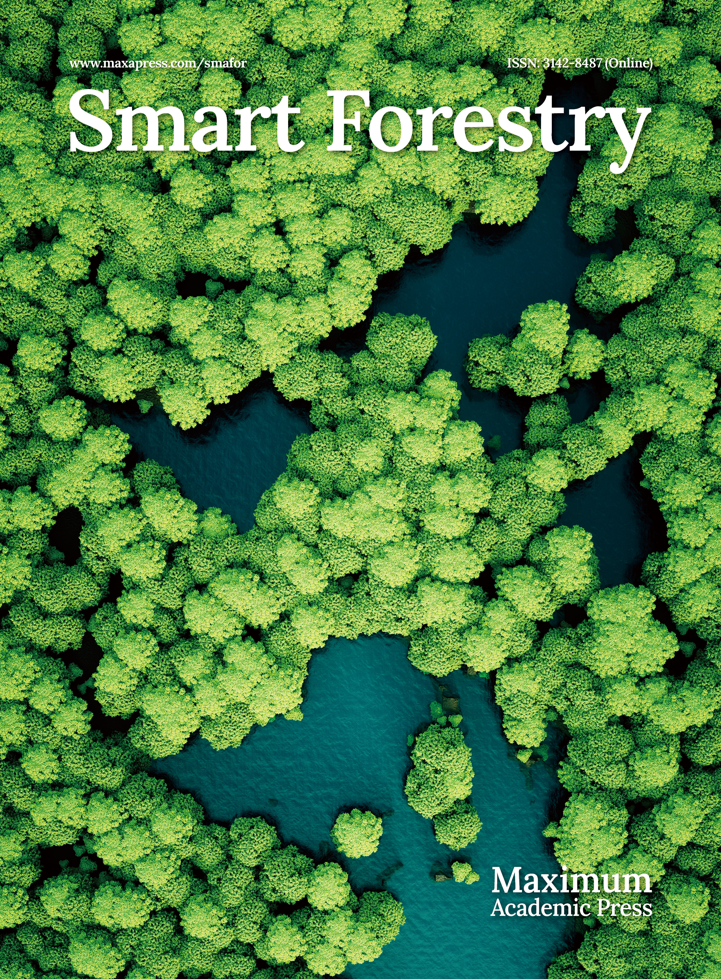
Technical features: multi-mode imaging; spatial resolution: 0.5 m.[4,5] By understanding the research background and development history of remote sensing technology in forest management, this study aims to systematically understand the current application status of remote sensing technology in comprehensive forestry management, analyze the advantages and limitations of technical methods, dissect the current bottlenecks and technical difficulties in the field, and to prospect future development trends, so as to provide scientific references for promoting the in-depth application of remote sensing technology in forestry management, as shown in Fig. 1.
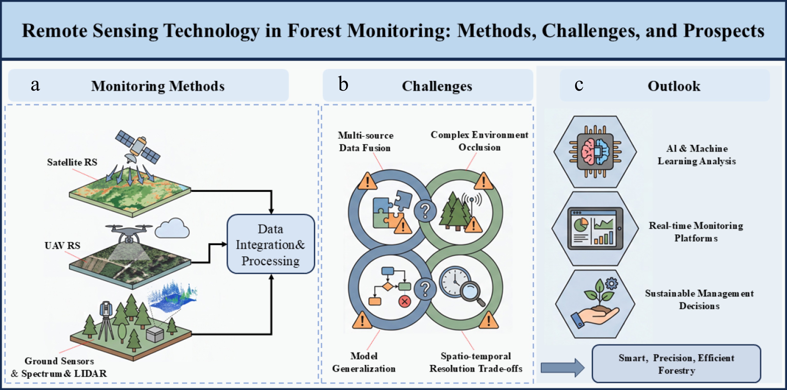
Figure 1.
Remote sensing technology in forest monitoring: methods, challenges, and prospects.
-
Common remote sensing technologies in forestry management mainly include spectral remote sensing, infrared & UAV thermal imaging remote sensing, satellite remote sensing, and air-ground collaborative remote sensing, as shown in Fig. 2.
Figure 2.
Remote sensing technologies: (a) spectral remote sensing; (b) infrared and drone thermal; (c) satellite remote sensing; (d) air-ground collaborative.
Spectral remote sensing
-
The working principle of optical remote sensing is mainly to capture solar radiation information reflected by the Earth's surface, providing a data basis for forest type identification and health status assessment. Multispectral and hyperspectral images can extract vegetation indices (such as NDVI, EVI, and LAI), which are widely used in forest productivity and phenology monitoring. Simultaneously, the use of sun/solar-induced chlorophyll fluorescence remote sensing technology is also an emerging direction in spectroscopic research. For example, long-term data provided by the Landsat series satellites (since 1972) have been used for global forest cover change analysis. Studies have shown that NDVI time-series data based on Landsat can accurately track the degradation of the Amazon rainforest[7]. Hyperspectral images, through subdivided spectral features, have successfully distinguished different tree species and even early stress from pests and diseases. Sun/solar-induced chlorophyll fluorescence remote sensing technology is a direct 'physiological probe' of vegetation photosynthesis, which can reflect stresses such as drought, high temperature, and pests and diseases earlier and more sensitively than traditional vegetation indices such as NDVI.
Multispectral remote sensing technology
-
Multispectral remote sensing acquires reflectance information of ground objects in specific bands such as visible light and near-infrared, and has strong penetrability of trees, enabling forest type identification, wood quality, and growth status assessment[8−10]. Vegetation indices are the core technology of multispectral remote sensing in forestry applications, among which the Normalized Difference Vegetation Index (NDVI) is the most widely used:
$ \mathrm{NDVI}=\dfrac{\text{NIR}-\mathrm{R}}{\mathrm{NIR}+\mathrm{R}} $ (1) where, NIR denotes the reflectance value of the near-infrared band, and R denotes the reflectance value of the red band.
Studies based on Landsat 8 OLI data have shown that NDVI is significantly positively correlated with forest Leaf Area Index (LAI), which can effectively assess forest growth status[11]. The calculation formula of LAI is:
$ \mathrm{LAI}=\dfrac{\mathrm{Leaf}\;\text{Area}}{\mathrm{Ground}\;\mathrm{Projection}\;\text{Area}} $ (2) Meanwhile, the Enhanced Vegetation Index (EVI) performs better in areas with high vegetation coverage:
$ \mathrm{EVI}=\dfrac{(\mathrm{NIR}-\text{Red})}{(\mathrm{NIR}+\mathrm{C}1\times \mathrm{Red}-\mathrm{C}2\times \text{Blue}+\mathrm{L})}\mathrm{G} $ (3) where, NIR represents the reflectance of the near-infrared band, Red represents the reflectance of the red band, and Blue represents the reflectance of the blue band, and G, C1, C2, and L are coefficients introduced to consider different environmental conditions.
However, the current technology still has problems such as low spectral resolution, limited bands, weak ability to accurately identify tree species and diagnose early stress, and is greatly affected by clouds, fog, and atmosphere, resulting in unstable data availability. Further research is needed to improve and solve these problems.
Hyperspectral remote sensing technology
-
Hyperspectral remote sensing has the characteristics and advantages of high spectral resolution (usually < 10 nm) and a large number of bands (> 100 bands), enabling the identification of subtle spectral differences. In forestry applications, some specific data processing technologies have been developed by combining the characteristics of hyperspectral images and the needs of forestry production[12,13]. In terms of tree species classification, Hyperion hyperspectral is usually used to achieve accurate identification of different tree species with high overall classification accuracy. Meanwhile, in forest monitoring, red edge parameters are important indicators of hyperspectral remote sensing in forest health monitoring, mainly considering the following three aspects:
(1) Red Edge Position (REP): reflects changes in chlorophyll content.
(2) Red Edge Slope: indicates the degree of vegetation stress.
(3) Red Edge Area: comprehensively reflects vegetation growth status.
Hyperspectral remote sensing technology can establish tree monitoring models and photosynthetic parameter simulation equations by measuring hyperspectral data and photosynthetic parameters (such as net photosynthetic rate) of trees, so as to quickly predict the occurrence period of pest damage and diagnose tree health status.
However, the technology still has problems such as large data volume, high redundancy, complex preprocessing and calculation, high computing power requirements and high cost, low data acquisition and coverage efficiency, and difficulty in large-scale high-frequency monitoring. Further optimization by relevant researchers is needed.
Sun/solar-induced chlorophyll fluorescence remote sensing technology
-
Light-induced chlorophyll fluorescence (SIF) remote sensing technology refers to a passive optical remote sensing technique that, under natural light conditions, directly detects the weak fluorescence signals emitted by chlorophyll molecules during photosynthesis in plants without damaging vegetation, thereby retrieving the physiological state of the vegetation[14]. The main principle of this technology is to excite plant chlorophyll to produce fluorescence through sunlight, and then use remote sensing sensors and spectral knowledge to detect the fluorescence signal with high precision in specific wavelengths, ultimately achieving the goal of forest information retrieval. It is primarily used to characterize parameters such as photosynthetic capacity and stress levels in vegetation. Furthermore, the fluorescence intensity is highly correlated with actual photosynthetic intensity and vegetation physiological state, and can also be used for the detection of related indicators.
However, this technology still has its limitations, including extremely weak signals, susceptibility to noise interference, generally low spatial resolution, lack of three-dimensional structural information, and significant influence from the atmosphere and light. Future research is needed to continuously optimize and improve this technology.
Infrared and UAV thermal imaging remote sensing
-
The working principle of infrared remote sensing is to detect surface thermal radiation, which is often used for forest water stress monitoring, fire point identification, and canopy temperature analysis. The application of UAV thermal imaging technology generally involves equipping UAVs with thermal imaging cameras, which can obtain centimeter-level resolution thermal data. Accurately quantifying forest structure is crucial for understanding ecosystem functions, which can make up for the lack of spatial resolution of satellite data. For example, in the monitoring of sudden forest fires, UAVs have high resolution and flexibility[15]. Equipped with thermal imaging, they can successfully identify surface fire points and smoldering areas, providing key information for firefighting decisions. Meanwhile, the canopy temperature retrieved by thermal infrared, combined with meteorological data can be used to calculate the water stress index, guiding precision irrigation or drought early warning.
Infrared technology
-
As a non-invasive technology, infrared technology has the advantages of rapidity, non-destructiveness, and cost-effectiveness. Common types mainly include near-infrared technology, mid-infrared technology, and thermal infrared technology. Among them, the near-infrared band (0.7–1.3 μm) is sensitive to vegetation biomass and is widely used in tree species differentiation, tree species prediction, and forest biomass estimation[16,17]; the mid-infrared band (1.3–8 μm) is sensitive to vegetation water content and is often used for forest water status monitoring. The Normalized Difference Water Index (NDWI) is an important water monitoring indicator of this technology; the thermal infrared band (8–14 μm) mainly reflects surface temperature information and is widely used in forest fire risk assessment[18]. Meanwhile, Land Surface Temperature (LST) is positively correlated with forest fire risk level. When LST > 35 °C, the forest fire risk level increases significantly. For example, Chambi-Legoas et al. discussed the use of near-infrared hyperspectral imaging (NIR-HSI) to predict the wood density of 6-year-old Eucalyptus grandis trees and evaluate the feasibility of early selection[19]; Pace et al. applied near-infrared spectroscopy (NIR) and multivariate analysis to quickly identify 12 native wood species in the Atlantic Forest. The study aimed to solve the identification problem in the illegal wood trade, and a classification model was established through NIR spectral differences with an accuracy rate exceeding 90%[20]; Meder discussed the importance of near-infrared spectroscopy in tree breeding, emphasizing that this method can quickly and non-destructively predict wood properties, overcoming the limitations of traditional methods that are time-consuming and costly[21].
However, the current technology still suffers from problems such as susceptibility to interference from ambient temperature, solar radiation, and wind speed, and its spatial resolution is usually low, making it difficult to use for monitoring at the single-tree scale. Further improvements to the technology are needed.
UAV thermal imaging technology
-
Using UAV platforms equipped with various optical information collection devices, combined with UAV remote sensing technology and supplemented by GPS precise positioning technology, can efficiently collect characteristic target information. High-resolution thermal imaging cameras equipped on UAVs can efficiently obtain phenotypic parameters such as forest morphological structure (tree height, crown width, leaf area index, biomass), physiological functions (water stress, pests and diseases), and biochemical components (chlorophyll, nutrients)[22,23], and even refine the monitoring scale to the individual tree or leaf level, which is suitable for agricultural and ecological monitoring fields. In forest fire management, UAV thermal imaging can penetrate smoke to accurately locate fire lines, embers, and underground smoldering points, providing real-time intelligence for firefighting command. UAV thermal imaging technology is usually used in forest fire monitoring and forest health assessment. For forest fire detection, because UAV thermal infrared sensors can effectively detect temperature differences in forests, they are often used for early warning of forest fires and play an important role in early warning of forest fires[24]. Common thermal anomaly detection algorithms usually adopt a fixed threshold method or a statistical threshold method, as follows:
(1) Fixed threshold method:
$ \Delta \mathrm{T}={\mathrm{T}}_{\text{pixel}}-{\mathrm{T}}_{\text{background}} $ (4) where, Tbackground is usually the average bright temperature or median bright temperature of pixels in the non-fire suspicious area around the target pixel, and Tpixel represents the bright temperature value of the pixel to be detected.
(2) Statistical threshold method:
$ {\mathrm{T}}_{\text{threshold}}={\text µ}_{\text{background}}+\mathrm{n}\times {\sigma }_{\text{background}} $ (5) where, μbackground is the mean value of background temperature, σbackground is the standard deviation, n is the threshold coefficient, and Tthreshold is the dynamic threshold.
In precision forestry and health diagnosis, thermal imaging can be used to diagnose trees with insufficient irrigation, individual plants affected by root diseases, and screening of drought-tolerant tree genotypes[25]. For forest health assessment, UAV thermal imaging technology is often used to detect the canopy temperature of forest vegetation. Vegetation canopy temperature is closely related to transpiration, which can be used as an indicator of forest water stress. The Crop Water Stress Index (CWSI) is widely used in forest health assessment:
$ \text{CWSI}=1-\dfrac{\text{ET}}{\text{PET}} $ (6) where, ET is the actual evapotranspiration, and PET is the potential evapotranspiration.
However, the current technology still suffers from problems such as being affected by factors such as weather, sunlight, unstable airflow, and flight altitude, as well as limited temperature inversion accuracy and difficulty in long-term network monitoring. Further optimization of the performance and characteristics of related equipment is needed.
LiDAR remote sensing technology
-
The application of lidar remote sensing technology in forest management is an important direction in international remote sensing and forestry research, and has become a core technology for measuring forest parameters and health status[26]. It is often used in conjunction with UAV technology. Currently, the basic operating principle of lidar remote sensing is to emit laser pulses to the ground through a mapping system. When the pulses encounter objects (tree canopy, branches, ground), they form reflected echoes. The receiver then records the echo time/phase, calculates the distance, and finally combines GNSS position and IMU attitude to calculate the three-dimensional coordinates (X, Y, Z), forming a point cloud image. The main advantage of this technology is that it can acquire multiple echoes (canopy, middle layer, ground), penetrate the tree canopy, and directly output three-dimensional structural information, rather than just image grayscale or spectrum. Its main application areas include: forest structure parameter inversion, individual tree segmentation and monitoring, forest biomass and carbon sink estimation, forest ecology and disturbance monitoring, and topographic and forestry basic mapping. It can effectively achieve high-precision quantitative observation from individual trees to stands, and from structure to carbon sinks, making it a core technology of modern forest remote sensing and ecological monitoring.
However, the technology still faces challenges such as large point cloud data volume, unstable single tree segmentation and classification algorithms, and limited monitoring capabilities for low-lying vegetation and seedlings in forests. Further optimization of its practical application capabilities is needed.
Satellite remote sensing: from optics to radar
-
Satellite platforms provide long-term global vegetation observation data that can be used for the estimation of canopy parameters[27]. The Sentinel-2 satellite (10–60 m resolution) supports the European forest disturbance monitoring system, and the obtained red edge bands significantly improve the accuracy of chlorophyll content estimation. The adoption of satellite radar remote sensing technology (such as Sentinel-1 C-band, ALOS-2 L-band) has the ability to penetrate clouds and part of the vegetation, which is mainly suitable for detecting forest height, biomass, and soil moisture inversion.
Optical satellite system technology
-
Among the optical satellite remote sensing series, based on the Landsat series satellites: providing continuous Earth observation data since 1972, the spatial resolution of this series of satellites is 30 m, and the revisit period is 16 d, which can effectively generate tree inventories[28]. Global forest change products based on data provided by Landsat have monitored global forest cover changes from 2000 to 2012, identifying an average annual forest loss area of 2.3 million km2, based on the Sentinel-2 satellite. This satellite can provide multispectral data with a spatial resolution of 10–60 m and a revisit period of 5 d; the accuracy of forest type classification using Sentinel-2 data can reach more than 90%, based on high-resolution satellites. The WorldView-3 satellite can provide 0.31 m panchromatic, and 1.24 m multispectral resolution, which can effectively realize individual tree identification and refined forest management, promoting the high-precision development of forestry monitoring. For example, Nie et al. evaluated the ability of ultra-high-resolution optical remote sensing satellite images in identifying pine wood nematode (PWN)-infected trees, focusing on analyzing the impact of spatial and spectral resolution, and found that ultra-high-resolution optical remote sensing satellites show great potential in identifying PWN-infected trees, providing a new technical approach for large-scale and high-efficiency forest disease monitoring[29]; Liu et al. used Sentinel-2 multispectral data and 74 subtropical forest plot inventory data to construct a Partial Least Squares Regression (PLSR) model to predict canopy tree diversity. The study focused on evaluating the impact of canopy definition methods and phenological changes on the model. The results showed that the model performance of spring and autumn images were the best, and the prediction R2 of diversity indices (such as the Berger-Parker index) could reach 0.63[30].
However, the current technology still suffers from problems such as a lack of three-dimensional information, the inability to directly obtain tree height, difficulty in balancing biomass with spatial resolution and swath width, and limitations in refined applications. Further improvements in the overall performance of related equipment are needed.
Radar satellite system technology
-
Synthetic Aperture Radar (SAR) has the ability of all-weather and all-time observation, and has unique monitoring advantages in cloud-covered areas. Sentinel-1 C-band SAR data performs excellently in forest deforestation monitoring[31], with a change detection accuracy of more than 85%; in forest biomass estimation, L-band SAR is sensitive to forest biomass, and has high estimation accuracy in forests with biomass < 150 t/ha. Studies have shown that the error of L-band radar data in tropical rainforest biomass estimation can be less than 20%[32], which is significantly better than the performance of optical data in dense forests. In the extraction of forest structure parameters, polarimetric SAR data can effectively extract forest structure parameters such as height and density, providing important information for forest management and facilitating the deployment of further forest management work.
However, the current technology still has problems, such as weaker tree species identification and health diagnosis capabilities compared to optical and hyperspectral technologies, complex backscattering mechanisms, and is susceptible to interference from humidity and roughness. Further improvements in anti-interference performance and efficiency are needed.
Air-ground integrated collaborative remote sensing monitoring
-
Air-ground integration usually achieves multi-scale and full-element forest monitoring through data fusion of satellites, UAVs, and ground sensors[33]. For example, in a forest carbon sink project in southwest China, combined with the GF-2 satellite (sub-meter level), UAV LiDAR, and ground plot surveys, high-precision mapping of forest volume was realized. UAV LiDAR can effectively obtain high-precision, three-dimensional canopy structure information of plants, making up for the lack of vertical structure information from satellite data and the limitations of traditional optical imaging, while ground sensors can provide real-time verification of parameters such as temperature, humidity, and soil carbon.
Multi-platform collaborative observation technology
-
The air-ground integrated monitoring system integrates data from multiple platforms such as satellites, aviation, UAVs, and ground observations. It fuses satellite data with wide-area coverage, aviation/UAV LiDAR data, providing refined three-dimensional structure and ground observations (fixed plots, flux towers, phenology camera networks) for calibration and mechanism understanding to realize multi-scale and multi-temporal forest monitoring. A typical monitoring system mainly includes the following four layers: (1) Satellite layer: capable of providing large-scale and long-time series observation data; (2) Aviation layer: capable of obtaining medium-resolution and flexible observation data; (3) UAV layer: capable of realizing high-resolution and low-cost local monitoring; (4) Ground layer: capable of providing authenticity, inspection, and accuracy of evaluation data.
However, the current technology still suffers from problems such as inconsistent data protocols, formats, accuracy, complex collaborative processes, inconsistent spatiotemporal references between platforms, and high registration difficulty. Further optimization of the collaboration between devices and platforms is needed.
Data fusion technology
-
In carrying out air-ground integrated collaborative remote sensing monitoring, data fusion technology is usually used to integrate and summarize the collected forest data. The common fusion methods are the following three points:
(1) Pixel-level fusion: fusing raw data from different sensors at the pixel level, such as Gram-Schmidt transformation, principal component analysis, and other methods.
(2) Feature-level fusion: extracting feature parameters of data from each sensor and then fusing them, such as the combined application of texture features and spectral indices.
(3) Decision-level fusion: fusing classification or identification results through methods such as voting, and weighted average to obtain the final result.
However, the current technology still suffers from problems such as strong heterogeneity of multi-source data, poor universality of fusion models, and a lack of a unified fusion quality evaluation system, which require further improvement in the uniformity of data fusion.
The above content is summarized in Table 2.
Table 2. Core technical characteristics of remote sensing for forestry management.
Technology category Technology subclass Advantages Disadvantages Applicable scenarios Ref. Spectral remote sensing Multispectral remote sensing technology 1. It can acquire reflectance information of ground objects in specific bands such as visible light and near-infrared, and has strong penetration through trees;
2. The vegetation index (NDVI, EVI, etc.) application system is mature, enabling quantitative analysis of forest parameters;
3. Long-term observation data is continuous (such as the Landsat series from 1972 to the present), supporting large-scale dynamic monitoring.1. Low spectral resolution and limited number of bands, resulting in weak capabilities for detailed tree species identification and early stress diagnosis;
2. Highly affected by clouds, fog, and atmospheric conditions, leading to unstable data availability.1. Forest type identification, timber quality and growth status assessment;
2. Forest productivity and phenological monitoring;
3. Estimation of growth parameters such as forest leaf area index (LAI).[8−11] Hyperspectral remote sensing technology 1. High spectral resolution and numerous bands enable the identification of subtle spectral differences in ground features;
2. Red-edge parameters accurately reflect health information such as chlorophyll content and
vegetation stress levels;
3. Monitoring models can be established to predict pest infestation periods and accurately diagnose tree health.1. Large data volume and high redundancy; complex preprocessing and calculation processes; high computational power requirements.
2. High cost; low efficiency in data acquisition and large-scale coverage; difficulty in high-frequency monitoring.1. Precise classification and identification of tree species;
2. Forest health monitoring and early stress diagnosis;
3. Prediction of forest pest infestation periods.[12,13] Sun/solar-induced chlorophyll fluorescence remote sensing technology 1. Non-destructive detection of vegetation photosynthetic fluorescence signals, serving as a direct 'physiological probe' of vegetation photosynthesis;
2. Reflects stresses such as drought, high temperature, and pests/diseases earlier and more sensitively than traditional vegetation indices like NDVI;
3. Fluorescence intensity is highly correlated with photosynthetic capacity and physiological state, enabling precise inversion of physiological parameters.1. The fluorescence signal is extremely weak and easily interfered with by noise;
2. The spatial resolution is generally low, lacking information on the three-dimensional structure of the forest;
3. It is significantly affected by atmospheric conditions and light factors.1. Measurement of vegetation photosynthetic capacity and stress level parameters;
2. Monitoring of early-stage drought, high temperature, and pest and disease stress in forests;
3. Dynamic monitoring of vegetation physiological status.[14] Infrared and UAV thermal imaging remote sensing Infrared technology 1. Non-invasive technology, characterized by speed, non-destructiveness, cost-effectiveness, and high efficiency;
2. Near-infrared spectroscopy is sensitive to vegetation biomass, mid-infrared spectroscopy is sensitive to water content, and thermal infrared spectroscopy can accurately reflect land surface temperature;
3. Indicators such as Normalized Difference Water Index (NDWI) and Land Surface Temperature (LST) are maturely applied.1. Susceptible to interference from external factors such as ambient temperature, solar radiation, and wind speed;
2. Typically has low spatial resolution, making it difficult to conduct detailed monitoring at the single-tree scale.1. Tree species differentiation and forest biomass estimation;
2. Forest moisture monitoring and drought early warning;
3. Forest fire risk assessment and preliminary fire point identification.[16,17] UAV thermal imaging technology 1. Capable of acquiring cm-level resolution thermal data, with monitoring scales refined to the level of individual trees or even leaves;
2. Able to penetrate smoke and accurately locate fire lines, embers, and underground smoldering points;
3. Combined with precise GPS positioning, it can efficiently acquire phenotypic parameters such as tree morphology and physiology;
4. Canopy temperature detection can directly indicate the state of forest water stress.1. Greatly affected by weather, sunlight, airflow, and flight altitude;
2. Limited temperature inversion accuracy, and equipment performance easily affected by environmental interference;
3. Difficult to achieve long-term continuous network monitoring.1. Early warning of forest fires, precise identification of fire spots/smoldering areas, and command of firefighting efforts;
2. Forest health assessment (diagnosis of water stress, identification of trees with insufficient irrigation);
3. Screening of drought-resistant tree genotypes;
4. Acquisition of forest phenotypic parameters (tree height, crown width, chlorophyll, etc.)[22,23] LiDAR remote sensing technology 1. Capable of acquiring multiple echo signals, penetrating the tree canopy, and capturing vertical structure information of the understory and canopy;
2. Directly outputs 3D coordinate point cloud images, providing 3D forest structure information;
3. Enables high-precision quantitative observation from individual trees to forest stands, with high parameter inversion accuracy.1. The point cloud data volume is large, making data processing difficult;
2. The single-tree segmentation and classification algorithms are still unstable and easily affected by noise;
3. The monitoring capability for low-lying vegetation and seedlings in the forest understory is limited.1. Inversion of forest structure parameters (tree height, crown width, canopy closure, etc.);
2. Individual tree segmentation and refined monitoring;
3. Precise estimation of forest biomass and carbon sinks;
4. Forest ecology and disturbance monitoring, basic forestry topographic mapping.[26] Satellite remote sensing Optical satellite system technology 1. Global coverage, providing long-term, continuous vegetation observation data to support large-scale forest monitoring;
2. Red-edge bands significantly improve the accuracy of estimating parameters such as chlorophyll content and canopy diversity;
3. High-resolution satellites (such as WorldView-3) enable individual tree identification, supporting refined management;
4. Forest type classification accuracy can reach over 90%.1. Lack of three-dimensional forest structure information makes it impossible to directly obtain parameters such as tree height and biomass;
2. Difficulty in balancing spatial resolution and swath width limits refined applications;
3. Blind spots exist in data acquisition due to cloud cover and weather conditions.1. Global/regional scale forest cover monitoring and change detection;
2. Large-scale forest type classification;
3. Large-scale monitoring of forest diseases such as pine wilt disease;
4. Canopy diversity prediction and assessment.[28−30] Radar satellite system technology 1. Possesses all-weather, all-time observation capabilities, penetrating clouds and some vegetation, suitable for areas covered by clouds and fog;
2. C-band (Sentinel-1) forest deforestation monitoring accuracy exceeds 85%;
3. L-band is sensitive to forest biomass, with biomass estimation error below 20%;
4. Polarimetric SAR can effectively extract structural parameters such as forest height and density.1. Its ability to identify tree species and diagnose forest health is weaker than that of optical and hyperspectral remote sensing;
2. The backscattering mechanism is complex and easily affected by factors such as soil moisture and surface roughness;
3. Biomass inversion suffers from a saturation effect.1. Dynamic monitoring of forests in areas prone to cloud cover/fog and rain;
2. Real-time monitoring of deforestation and vegetation destruction;
3. Estimation of forest biomass and
tree height;
4. Forest soil moisture inversion and structural parameter extraction.[31,32] Air-ground integrated collaborative remote sensing monitoring Multi-platform collaborative observation technology 1. Integrate data from multiple platforms including satellite, aerial, UAV, and ground sensors to achieve multi-scale, comprehensive, and multi-temporal forest monitoring;
2. Overcome the limitations of data from single platforms;
3. Ground data can provide verification of accuracy and evaluation of remote sensing inversion.1. Inconsistent protocols, formats, and accuracy of data across different platforms complicate collaborative observation processes;
2. Inconsistent spatiotemporal references between platforms make data registration difficult;
3. High costs associated with coordinating equipment and synchronizing data across multiple platforms.1. High-precision monitoring and volume mapping of forest carbon sink projects;
2. Comprehensive inversion of large-scale forest parameters from multiple sources;
3. Comprehensive ecological monitoring of national parks and key forest areas.[33] Data fusion technology 1. Integrates the advantages of multi-source sensor data to achieve information complementarity and improve monitoring accuracy and information integrity;
2. Multi-dimensional fusion at the pixel, feature, and decision levels adapts to different forestry monitoring needs;
3. Optimizes forest classification and identification results, improving the accuracy of change detection.1. Multi-source remote sensing data exhibits strong heterogeneity, resulting in poor versatility and low adaptability of fusion models;
2. The lack of a unified fusion quality evaluation system makes it difficult to standardize the accuracy of results;
3. Complex fusion algorithms require high computing power and specialized technical expertise.1. Multi-source data integration and information extraction in integrated air-ground monitoring;
2. Classification and identification result optimization in forest monitoring;
3. Comprehensive analysis of multi-data sources for forest change detection and disaster monitoring.[33] -
Forest area monitoring based on remote sensing technology has become an important means of national forest resource inventory. The 8th National Forest Resource Inventory of China adopted satellite remote sensing technology to collect data, combined with ground surveys, and determined that the national forest area is 208 million ha with a forest coverage rate of 21.63%.
In carrying out forest area monitoring, the technical operation process is mainly divided into the following four points:
(1) Conduct image preprocessing: geometric correction, radiometric correction, atmospheric correction.
(2) Conduct forest/non-forest classification: based on NDVI thresholds or supervised classification methods.
(3) Accuracy verification: conduct an accuracy evaluation combined with ground survey data.
(4) Area statistics: calculate forest area based on classification results.
Xie et al. used textural features (such as mean value, variance), spectral indices (such as NDVI, SAVI), and topographic factors (altitude, slope) of SPOT5 remote sensing images to invert stand average diameter, basal area, volume, and tree species diversity index through multiple stepwise regression. The research results showed that the 9 × 9 window is the optimal texture extraction scale, and the model accuracy was significantly improved after introducing topographic factors (volume model R2 = 0.864), which can effectively identify forest area and tree species diversity[34]. Sankey et al. studied forests in Arizona, USA, using remote sensing technology fusing UAV LiDAR and hyperspectral data to monitor tree species classification and structural parameters (such as tree height, crown width), and compared with the SFM method. The final research results showed that the overall accuracy of the fusion method reached 88%, which was higher than that of single data[35]. Battison et al. studied the use of repeated Airborne Laser Scanning (ALS) data to track the 9-year dynamics of 42,000 trees in the Great Western Woodlands of Australia analyzed the impact of size, competition, and terrain on growth and mortality, and provided a new approach for large-scale forest dynamic structure modeling using individual tree remote sensing methods[36]. Otero et al. evaluated the feasibility of using lightweight UAVs, RGB images, and 'Structure from Motion' (SFM) technology to obtain mangrove structure information in Malaysian mangrove reserves, and found that UAV remote sensing can assist in mangrove monitoring, especially in production areas[37]. Bansal et al. proposed an innovative method called Briefly Optimised Recognition (BRO), which combines deep learning and the BRO algorithm to perform accurate tree counting using high-resolution satellite images, aiming to solve the problems of high cost, low efficiency, and error-proneness of traditional manual-counting methods. The research results showed that this method has higher computational efficiency and is suitable for large-scale forest monitoring applications[38].
Tree species identification and classification
-
In tree species identification and classification, spectral feature analysis and machine learning methods are usually used. Spectral feature analysis is usually judged according to the significant spectral differences of different tree species in bands such as red edge and near-infrared, while machine learning methods usually adopt Random Forest, Support Vector Machine (SVM), and deep learning methods. Convolutional Neural Network (CNN) performs excellently in tree species classification of high-resolution images. A review by Li et al. showed that the combination of deep learning and LIDAR point cloud data has also made good progress in three-dimensional spatial analysis and tree species identification[39]. Li et al. proposed an object-oriented classification method, combining GF-1 multispectral data and MODIS NDVI time series to improve the accuracy of forest resource monitoring. The method includes image segmentation, feature extraction, and the Random Forest algorithm. The final verification results showed that the overall classification accuracy reached 89.46%[40]. Miao et al. proposed a two-stage network combining PointNet++ and CNN to solve the problem that traditional individual tree segmentation methods are affected by noise and occlusion when processing large-scale remote sensing point cloud data, and achieved high-precision segmentation through latent feature similarity and adaptive KNN diffusion, with an average accuracy of 96.33%[41]. Chu et al. proposed a CNN-EGNet model combined with the ECA attention mechanism to realize tree species identification in coniferous and broad-leaved mixed forests based on UAV hyperspectral and LiDAR data. The research results showed that the overall accuracy (OA) of CNN-EGNet reached 89.58%, and the Kappa coefficient was 0.866, which was better than traditional models such as VGG16 and GoogLeNet[42]. Zhao et al. constructed a 3D-CNN model to directly process hyperspectral cube data to solve the problem of high dimension and small samples of airborne hyperspectral data, realizing tree species classification in Gaofeng Forest Farm, Guangxi. The final research results showed that the overall classification accuracy of 3D-CNN reached 98.38%, and the Kappa coefficient was 0.98, which was significantly better than 2D-CNN and traditional methods[43]. Mäyrä et al. used airborne hyperspectral and LiDAR data to classify four tree species (pine, spruce, birch, aspen) in Finnish boreal forests using 3D Convolutional Neural Network (3D-CNN). The research method adopted 3D-CNN to automatically extract spatial-spectral features, which was generally better than traditional models such as SVM and RF; occlusion and saliency maps were used to explain model decisions, and the overall accuracy of the best 3D-CNN model could reach 87%[44]. Lin et al. used ground-measured hyperspectral remote sensing (HR-768 spectrometer) to identify four desert tree species: Populus euphratica, Tamarix chinensis, Haloxylon ammodendron, and Calligonum mongolicum. The main research methods included continuum removal, first-order and second-order differential transformation, selecting bands with significant differences using the Mahalanobis distance method, and verifying the identification effect through stepwise discriminant analysis. The analysis results showed that hyperspectral transformation processing can improve the identification accuracy, laying a foundation for remote sensing classification of desert plants[45]. Barotto et al. used NIRS remote sensing calibration models to predict the anatomical characteristics (such as vessel size, fiber wall fraction) and functional characteristics (such as hydraulic conductivity, vulnerability curve parameters) of two temperate Eucalyptus species. Prediction models were established using Partial Least Squares Regression (PLSR) and Competitive Adaptive Reweighted Sampling (CARS) algorithms. The final Model Fitting Index (MFI) showed that the best predictors were closely related to wood anatomical structure[46]. Schimleck et al. adopted near-infrared hyperspectral imaging (NIR-HSI) technology combined with cluster analysis to non-destructively classify the wood properties of Pinus taeda grown in southern Brazil, so as to quickly screen wood with ideal wood properties[47]. Dziczkowski et al. proposed an automatic method for detecting and evaluating urban trees by combining satellite images, height maps, and image processing technology to support the sustainable management of urban green spaces[48]. Fu et al. used multi-source remote sensing data to identify, classify, and estimate the area of economic forest tree species. Their research successfully mapped the distribution of major economic tree species (such as walnuts, jujubes, and grapes) in Xinjiang, China, and analyzed their spatiotemporal dynamics[49].
Forest volume and biomass estimation
-
Using remote sensing technology to estimate forest volume and biomass is an effective method for forest monitoring. In the estimation of forest volume and biomass, forest volume and biomass are important indicators for forest resources. Usually, optical remote sensing is used for estimation in forest inspection. The estimation method of optical remote sensing data mainly uses the empirical relationship between vegetation indices and forest parameters to judge:
$ {\mathrm{AGB}=\mathrm{a}\times \text{VI}}^{\mathrm{b}}+\mathrm{c} $ (7) where, VI represents vegetation indices such as NDVI, EVI, SAVI, etc., a, b, and c represent coefficients obtained by regression fitting between ground plot AGB and corresponding pixel VI values, and AGB represents above-ground biomass.
Luo et al. summarized that at present, forest volume is mainly estimated through optical remote sensing (such as Landsat TM/ETM/OLI, MODIS, SPOT5, Gaofen series), Synthetic Aperture Radar (SAR) (such as Terra-SAR, ALOS, PALSAR), and LiDAR. Among them, LiDAR has the highest accuracy and is suitable for small-scale forest volume surveys[50]. Therefore, LiDAR technology is also an efficient method for detecting forest volume and biomass estimation. Common airborne LiDAR can directly and effectively obtain three-dimensional forest structure information, which has significant advantages over traditional methods in forest biomass estimation. LiDAR point cloud data can extract a variety of forest structure parameters, mainly including: (1) Canopy Height Model (CHM): reflecting forest vertical structure; (2) Point cloud height percentiles (H25, H50, H75, and H95): characterizing canopy height distribution; (3) Canopy coverage: indicating forest canopy density; and (4) Leaf area density profile: reflecting the vertical distribution of leaf area.
Compared with commonly used airborne LiDAR, spaceborne LiDAR is often used for large-scale forest monitoring and management. NASA's Global Ecosystem Dynamics Investigation (GEDI) mission is carried on the International Space Station, providing real-time global forest structure data through spaceborne LiDAR. GEDI mainly adopts full-waveform LiDAR technology, with a footprint diameter of 25 m, which can accurately and effectively measure forest canopy height and vertical structure. Zhang et al. studied Pinus sylvestris var. mongolica and Populus in Zhangwu County, extracted features such as height, intensity, texture, and vegetation indices by combining UAV LiDAR and RGB images, and constructed individual tree Above-Ground Biomass (AGB) inversion models using Random Forest (RF), XGBoost, and CatBoost models. The results showed that point cloud height and canopy structure are key features for AGB estimation, and texture features make a significant contribution to the AGB inversion of Pinus sylvestris var. mongolica[51]. Santini et al. introduced a case study using UAV multispectral, RGB, and thermal imaging remote sensing technology to evaluate the genetic variation of 56 pine populations in functional traits. The research results found that vegetation indices (VIs) and canopy temperature can act as a proxy for canopy structure, leaf area, and water use, and are related to above-ground biomass[52]. Zhao et al. proposed a method to estimate the AGB of individual urban forest trees based on a true three-dimensional real scene model constructed by UAV oblique photogrammetry. The study took Ginkgo biloba and Cinnamomum camphora as research objects, obtained multi-angle images through UAV five-direction flight, constructed a three-dimensional real scene model using Structure from Motion (SfM) and Multi-View Stereo (MVS) algorithms, and extracted structural parameters such as tree height, crown width, and crown volume from it[53]. Zou et al. collected data through airborne remote sensing hyperspectral cameras, calculated a variety of vegetation indices (such as EVI, OSAVI), and classified the growth rate of Cunninghamia lanceolata using multiple algorithms such as decision tree, RF, SVM, and XGBoost. The final research results showed that the Random Forest (RF) model had the highest prediction accuracy (75%), which was better than XGBoost (67%), and the key vegetation indices were strongly correlated with forest biomass[54]. Schlerf et al. systematically evaluated the linear prediction models between vegetation indices derived from HyMap hyperspectral data and field-measured forest biophysical variables. Through cross-validation, the performance of broadband (such as Landsat TM bands) and narrowband vegetation indices was compared. The results showed that hyperspectral data can more accurately predict LAI and crown volume than multispectral data[55]. Yahaya et al. used remote sensing indices and MaxEnt species distribution models to study the distribution of canopy and non-canopy species in Taraba State, Nigeria, to support biodiversity conservation. The final results showed that precipitation and temperature seasonality are key factors affecting species distribution, and non-canopy species are more vulnerable to drought stress[56]. Compton evaluated the relationship between IR/Red ratio and vegetation biomass and chlorophyll content through field spectrometer data. The research results showed that the IR/Red combination is more effective than the Green/Red combination and can accurately monitor photosynthetically active biomass[57]. Lu et al. proposed a new method combining UAV LiDAR (UAV-LiDAR) and Backpack LiDAR (Backpack-LiDAR) point cloud data to accurately estimate forest biomass in response to the withering and death of Robinia pseudoacacia forests in the Yellow River Delta[58]. Chen et al. proposed a method integrating UAV-LiDAR and Sentinel-2B data to estimate the biomass of tropical forests in Hainan, China[59].
Biodiversity monitoring and quantitative assessment of ecosystem service functions
-
Remote sensing technology provides a comprehensive, dynamic, and standardized technical means for biodiversity monitoring and ecosystem service function assessment. It overcomes the spatial and temporal limitations of traditional ground surveys and upgrades research from qualitative description to quantitative inversion, becoming a core support for ecosystem protection and valuation. In the dimension of biodiversity monitoring, the collaborative analysis of multi-source remote sensing data enables the implementation of the entire technology chain: high-resolution optical satellite and UAV RGB imagery is used to complete fine-grained habitat classification, accurately delineating habitat types such as forests, shrublands, and wetlands, as well as their internal landscape patterns; combining LiDAR 3D point clouds and hyperspectral remote sensing features, a correlation model between species distribution and habitat factors is constructed, achieving accurate inversion of species distribution and enabling dynamic monitoring of the habitat range and suitability levels of rare and endangered species; and based on time-series remote sensing data, indicators such as vegetation productivity, habitat connectivity, and community structure complexity are extracted to complete the quantitative characterization of key dimensions of biodiversity.
At the level of ecosystem service function assessment, remote sensing technology can realize the quantitative and spatial accounting of various functions: by inverting parameters such as net primary productivity and vegetation cover through optical and SAR remote sensing, the carbon sequestration and oxygen release, and soil and water conservation functions of the ecosystem can be quantified; by using hyperspectral remote sensing to analyze vegetation biochemical components and combining them with hydrological remote sensing data, the regulatory service functions such as water conservation and nutrient cycling can be assessed; and through landscape remote sensing index analysis, the cultural service function value of the ecosystem, such as recreational tourism and cultural heritage, can also be calculated.
In relevant typical application cases, Luo et al. explored the fusion of airborne LiDAR and hyperspectral images to estimate forest aboveground and belowground biomass. The results showed that LiDAR can overcome the problem of optical data saturation, and the fusion of multi-source data can improve the estimation accuracy, which is crucial for carbon cycle research[60]. Yan et al. estimated subtropical forest biomass and species diversity at the single tree scale by fusing airborne LiDAR point cloud and UAV multispectral image features. By screening high-dimensional features (such as height, intensity, and texture), biomass prediction models of different tree species were compared to improve the accuracy of carbon sink assessment[61]. Maesano et al. used UAV high-resolution RGB images and LiDAR data, combined with ground surveys, to estimate aboveground biomass (AGB) of pine forests in southern Italy[62].
Forest disaster monitoring and assessment
Forest fire monitoring
-
In forest fire monitoring, satellite remote sensing thermal anomaly monitoring is the main means of early forest fire warning. Thermal anomaly products of MODIS and VIIRS sensors are the main data sources for global fire monitoring. The main principle of the MODIS fire detection algorithm is based on the brightness temperature difference between the mid-infrared and thermal infrared bands: the working principle of VIIRS for fire analysis is mainly to identify the difference in surface reflectance between fire pixels and background pixels in the reflection band, and the difference in brightness and temperature in the thermal infrared band. In the fire situation monitoring of forest fires, UAV remote sensing technology equipped with thermal infrared cameras is usually used to achieve refined monitoring of forest fires. The main configuration of a typical system includes: (1) Carrying platform: multi-rotor or fixed-wing UAV; (2) Carrying load: radiation temperature measurement type thermal infrared camera; (3) Positioning method: Real-Time Kinematic (RTK) differential positioning; (4) Transmission method: real-time image transmission.
A review by Zhang et al. pointed out that a forest fire monitoring system combining visual-infrared cameras at fixed points in forest areas and UAV platforms can, in real time, obtain the location of fire points in forest areas, fire spread speed, and maximum flame height; a real-time forest fire monitoring system based on forest UAVs can realize real-time regulation of fire sources in forest areas on the basis of obtaining remote forest fire information, enabling forest fire protection personnel to quickly grasp the number and location of fire points[63]. Christensen analyzed the application potential of UAV and Forward-Looking Infrared (FLIR) remote sensing technology in emerging fire management, and found that the UAV-FLIR combination can reduce firefighting costs by 31%, and the return on investment is higher than that of traditional helicopter thermal imaging technology[64].
Pest and disease monitoring and health assessment
-
In the monitoring and health assessment of forest pests and diseases, spectral diagnostic remote sensing technology is usually used. Forest pests and diseases affect leaf physiological status, leading to changes in spectral reflectance characteristics. Pest and disease diagnosis can be carried out according to spectral characteristic differences. In the early stress stage, the blue shift of the red edge position (moving to the short-wave direction) is an important indicator for pest and disease diagnosis; in special cases, UAV hyperspectral remote sensing or satellite monitoring is also used. The integration of UAV-mounted hyperspectral sensors and satellite remote sensing can realize early refined monitoring of pests and diseases and overall health assessment of forests; Zhang et al., studying the damage of Eucryptorrhynchus chinensis and Eucryptorrhynchus brandti to Ailanthus altissima, used UAV multispectral images and machine learning models to classify damage levels based on the rate of withered shoots, verifying the feasibility of remote sensing monitoring[65]. Bozzini et al. used UAV multispectral images to evaluate the feasibility of early detection of European spruce bark beetle infestation in large spruce forest areas. By analyzing vegetation indices and comparing the spectral characteristics of healthy and infested trees, the aim is to provide a remote sensing method for pest and disease management[66]. A review by Zhou et al. pointed out that in the application of visible light imaging technology, many scholars use visible light RGB cameras mounted on ground platforms, or UAV platforms combined with machine vision to effectively obtain the color characteristics, lesion shape and size, texture characteristics, and other apparent morphologies of roots, stems, leaves, fruits, or the overall canopy caused by different pests and diseases[67]. Infrared thermal imaging remote sensing technology, as a non-contact temperature detection technology, can effectively detect leaf temperature, withered branches and leaves, and tree transpiration attenuation. Wang et al. used a NEC TH7100 thermal infrared camera (wavelength 8–14 μm) to take in vivo images of Ginkgo biloba and Liquidambar styraciflua leaves, and designed a vein cutting experiment to induce local water deficit. The final results showed that high-temperature areas appeared on the leaves after vein cutting, which was related to the attenuation of transpiration cooling. The high-temperature areas coincided with the red parts of the leaves, indicating that water deficit triggered the photoprotection mechanism, which can be used for tree health assessment[68]. Guo et al. proposed a method for extracting healthy crowns of new Pinus tabulaeformis plantations under complex ground vegetation conditions based on UAV high-resolution images (ZH20T camera). The method mainly includes enhancing images using homomorphic filtering, ExG spectral index transformation, segmenting crown areas using multi-scale morphological filtering, and combining a Random Forest Classifier (using color vectors, GLCM, and LBP features). The research results found that this method can effectively segment interleaved crowns, exclude grassland interference, and the extraction rate reaches 96.78%[69]. Shara et al. studied the use of UAV remote sensing equipped with multispectral cameras to monitor 20th-century landscape forest belts in Priestclose Wood, UK, combined with Principal Component Analysis (PCA) and k-means clustering to identify non-native invasive tree species, and the final results can efficiently distinguish Pinus nigra, Acer platanoides, and other tree species[70]. Das et al. used Sentinel-1 and Sentinel-2 satellite data, combined with machine learning (Random Forest RF and Support Vector Machine SVM) to estimate the Leaf Area Index (LAI) and Live Crown Ratio (LCR) of eastern white pine in Maine, USA, and integrated canopy height and stand density to develop a new stand health index map to support forest health monitoring[71].
Forest dynamic change monitoring
Forest cover change monitoring
-
In forest dynamic monitoring, monitoring data is mainly based on Landsat and Sentinel-2, and radar remote sensing is used for data monitoring in some special cases. Internationally, Hansen et al. sorted out Landsat time-series data from 2000 to 2012 and established a Global Forest Change (GFC) dataset with a spatial resolution of 30 m. The research results showed that the global forest loss area is 2.3 million km2, and the global forest gain area 800,000 km2, resulting in a net forest loss area of 1.5 million km2. Tropical forest losses accounted for 32% of the global total[7]. The main technical route adopted by the GFC dataset includes: (1) Image time-series construction and cloud detection; (2) Pixel-based spectral-temporal feature extraction; (3) Decision tree classifier training and application; and (4) Change detection and annual update. In China's forest monitoring, through satellite remote sensing analysis of forest dynamics, research results showed that from 2000 to 2020, the forest restoration effect in Northeast and Southwest China was significant; the area of artificial forests increased significantly, and China's artificial forest area increased by about 447,500 km2 (an increase of 93%), and the net increase of forest area was about 26 million ha[72−74]. Yao et al. used high-resolution satellite images (GF-II, 0.8 m) to count trees using deep neural networks (such as Encoder-Decoder networks), converted the problem into a density regression task, evaluated the performance of different networks, and monitored forest density and coverage[75]. Liu et al. proposed an automatic extraction method combining Terrestrial Laser Scanning (TLS) and UAV LiDAR point clouds for estimating the Diameter at Breast Height (DBH) and tree height parameters of individual trees in forest areas. The method extracts individual trees by dividing horizontal grids and counting point cloud features (such as the number of points, height difference), uses the RANSAC algorithm to fit DBH, and measures tree height from UAV point clouds. The experiment verified the effectiveness of the method with pine forests in the Qintang Forest Farm, Guigang City, providing a reference for forest cover change surveys[76]. Hewarathna et al. proposed a pipeline based on Siamese Attention U-Net for detecting forest cover changes. By improving the U-Net architecture and integrating attention mechanism, high-precision change detection is achieved with a small amount of labeled data, supporting timely forest monitoring[77].
Forest disturbance monitoring
-
Common forest disturbances include natural disturbances (fire, pests and diseases, wind disasters, etc.) and human disturbances (logging, reclamation, etc.). Different disturbance types show different temporal-spectral characteristics in remote sensing images:
(1) Clear-cutting disturbance: NDVI drops sharply (decrease > 0.3) with a long recovery period.
(2) Fire disturbance: significant changes in Normalized Burn Ratio (NBR) accompanied by thermal anomaly signals.
(3) Pest and disease disturbance: gradual decline of NDVI and obvious changes in red edge parameters.
(4) Selective logging: slight decline of NDVI and changes in texture features.
For the identification of disturbance events in forests, Kennedy et al. proposed the LandTrendr algorithm, which is an important method for forest disturbance monitoring. By analyzing the spectral trajectory of Landsat time series, the occurrence time, duration, and recovery process of disturbance events can be identified[78]. Zhang et al. used the LandTrendr algorithm to monitor the disturbance of subtropical forests in Hunan Province, China. The research period covers from 1991 to 2021. The research focuses on analyzing the spatiotemporal dynamics, patch size, and severity changes of forest disturbances, and found that forest disturbances have significant impacts on carbon storage, biodiversity, and ecological functions[79]. Verbesselt et al. proposed the Breaks For Additive Season and Trend (BFAST) algorithm, which can detect breakpoints in time series and is widely used in forest disturbance monitoring. Studies have shown that based on MODIS 16-d synthetic NDVI data and the BFAST algorithm, forest disturbance events can be effectively detected, tree death caused by drought can be identified, and a high-precision identification function can be retained[80]. Zhu et al. used the BFAST method to analyze MODIS EVI time series (2000–2022) to detect disturbance events of forests in East Asia, South Asia, and Southeast Asia and quantified resilience. The research results showed that 20% of the forests experienced disturbances (the most serious in Southeast Asia), but 95% of the forests showed strong resilience, and about 66% had recovered to the pre-disturbance state by 2022. The average recovery time is 20 years, and the overall recovery time is related to disturbance intensity and forest type[81]. Win et al. focused on young teak plantations in the West Bago Mountains of Myanmar, integrated multi-source remote sensing data and deep learning models to detect changes in above-ground carbon storage from 2019 to 2023. The research results found that 89% of the study area had an increase in carbon storage, and 11% had a decrease, which intuitively reflected the growth dynamics and local disturbances of teak forests[82].
Forest degradation monitoring
-
When carrying out forest degradation monitoring, forest degradation usually refers to the process of forest quality decline, but not completely transforming into non-forest. Monitoring is difficult, and correct monitoring indicators need to be selected for effective monitoring. The main monitoring indicators include: (1) Canopy coverage change: canopy segmentation analysis based on high-resolution images; (2) Biomass loss: biomass change detection based on SAR or LiDAR; and (3) Forest structure change: texture feature and spatial heterogeneity analysis.
Research by Reiche et al. on forest degradation monitoring based on Sentinel-1 SAR data showed that dense Sentinel-1 C-band Synthetic Aperture Radar data, observed once every 12 d, can effectively and timely detect forest cover loss with a monitoring accuracy of more than 95%[83]. Sun et al. measured the uncertainty of walnut canopy temperature using an infrared thermal imaging system (Model A310f)[84], mainly by measuring the temperature of sample trees in different directions and elevation angles, combined with parameter sensitivity analysis. The research results found that canopy temperature is most affected by leaf emissivity, followed by ambient reflection temperature. The analysis results are used to monitor the changes of walnut forests. Mazurek et al. evaluated the application potential of UAV-based multispectral remote sensing technology in large-area tree risk assessment in forestlands. The study conducted experiments in Scots Pine forests in Poland and compared the UAV survey results with ground field survey results. The research results showed that the UAV method can detect 78% of the dead or declining trees found in ground surveys[85]. North et al. developed an automatic method based on time-series satellite images (Sentinel-2) to map bare land caused by winter grazing and forestry logging in hilly areas of New Zealand (slope ≥ 7°) to support the C-factor estimation of soil erosion models. The goal is to provide national-scale spatial data of bare land for policy formulation and understand the situation of soil erosion and degradation in forestlands[86].
The above common application scenarios are shown in Fig. 3.
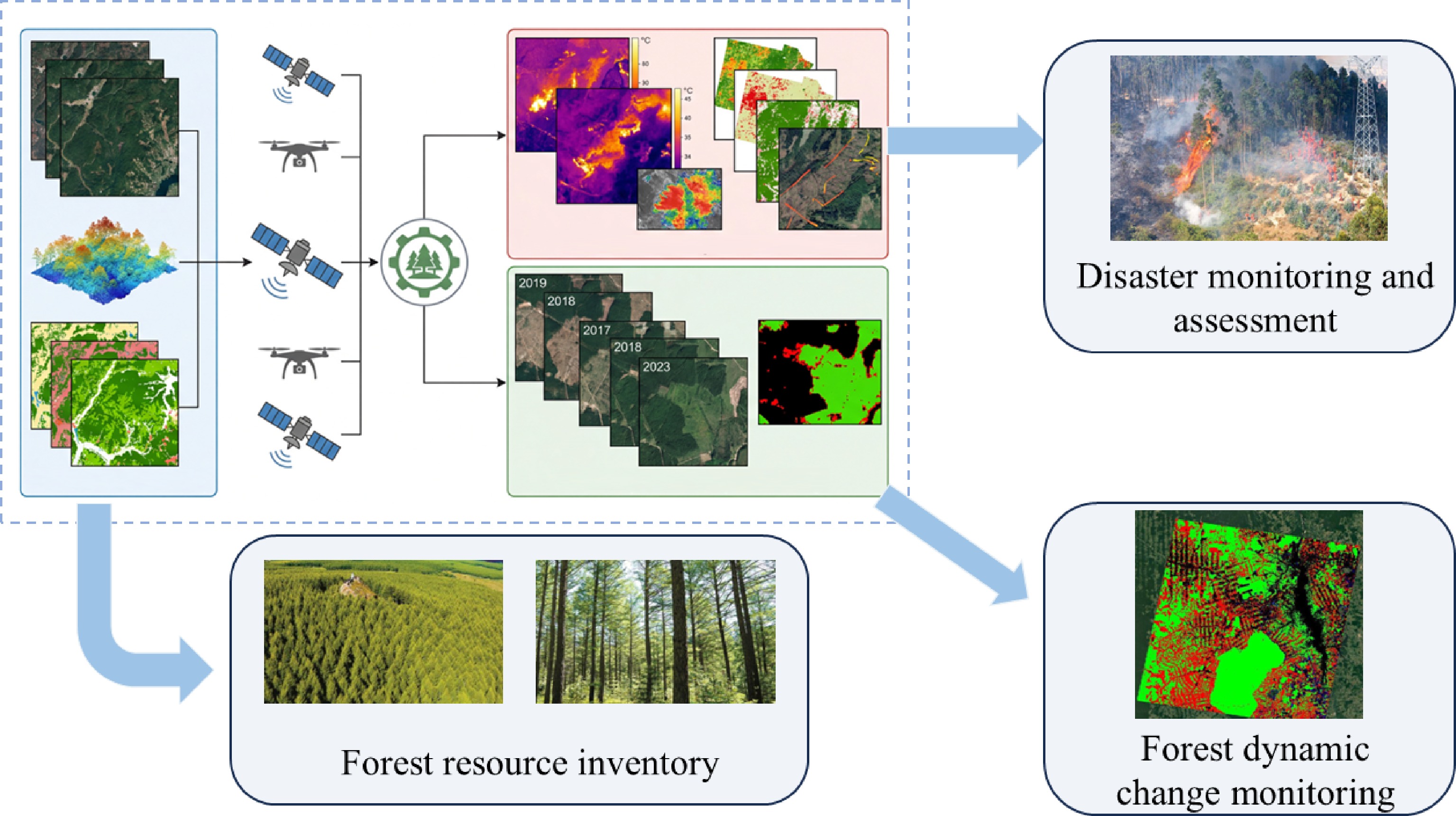
Figure 3.
Specific applications of remote sensing in forests.
-
Although remote sensing technology has brought revolutionary observation capabilities to forestry, on the path to realizing operational, precise, and universal 'smart forestry', it still faces a series of systematic challenges from underlying technology to upper-layer application, which needs continuous improvement and perfection in the future.
Technical level: the triple game of signal, environment, and algorithm
-
At present, the technical application of remote sensing technology in forestry management mainly has the following four problems:
(1) Complexity of data fusion and information extraction: multi-source data fusion is by no means a simple superposition of layers. Optical, LiDAR, SAR, and other data have inherent differences in spatial resolution (meter-level to km-level), time frequency (hour to month), observation geometry (zenith angle, azimuth angle), and physical meaning (reflecting reflectance, structure, dielectric properties). Developing fusion algorithms that can achieve semantic alignment and complementary advantages rather than error propagation (such as feature-level fusion based on deep learning, decision-level fusion based on physical models) is the core challenge. In addition, automatically extracting refined information such as individual tree location, tree species, and stress status from massive data still requires algorithms to balance generalization, efficiency, and accuracy, and continuously optimize performance to promote the expansion of remote sensing technology to large-scale screening[87].
(2) Signal saturation and inversion uncertainty: this is a fundamental limitation of quantitative remote sensing. Optical vegetation indices (such as NDVI) tend to saturate when the Leaf Area Index (LAI) reaches 3–4, making it difficult to distinguish mature forests from over-mature forests. The backscatter intensity of SAR's L-band tends to saturate when the biomass is about 150–200 Mg/ha. Although the P-band is improved, it is still not infinitely linear[88]. Crucially, all inversion models contain unquantified uncertainties, which come from atmospheric correction errors, model simplification, parameter empiricism, etc., and will propagate nonlinearly in geographical space, and among different forest types. How to systematically quantify, transmit, and ultimately express this uncertainty in products (such as providing confidence interval maps) is a prerequisite for improving decision-making credibility.
(3) Interference of terrain and canopy structure: in rugged mountainous areas, terrain not only causes serious shadows and radiation distortion, but also leads to layover and foreshortening in SAR images, which greatly increases the difficulty of extracting effective forest information[89]. The dense canopy is a 'green wall', and optical signals are difficult to penetrate to the understory, resulting in almost blank related technologies for monitoring the regeneration layer, shrub layer, and litter. While SAR and LiDAR signals can partially penetrate, their sensitivity to fine woody debris and soil organic matter is limited, restricting the accurate estimation of total ecosystem carbon storage.
(4) Coordination between satellite remote sensing, UAV remote sensing and ground monitoring: in forestry monitoring, although satellite remote sensing achieves wide-area coverage, it has a shortcoming in spatial resolution. UAV remote sensing can complete fine-scale observations, but is limited by endurance and airspace; ground monitoring can obtain accurate, true data, but faces problems of high labor costs and insufficient coverage, which greatly affect the efficiency of multi-source data fusion and application value. Satellite remote sensing offers a 'macroscopic perspective', providing large-scale, long-term data that can establish a basic framework for comprehensive monitoring. However, it struggles to capture forest details at the individual tree level and microscale. UAV remote sensing, as a 'mesoscopic supplement', enables cm-level high-resolution observations and precise extraction of fine parameters such as individual tree morphology and canopy structure. However, it is often constrained by factors such as flight radius and weather conditions, hindering continuous cross-regional monitoring. Ground-based monitoring provides a 'microscopic truth', with measured data obtained through plot surveys and fixed-point sensor observations serving as the core basis for calibrating and verifying the accuracy of remote sensing inversion models. However, its long operational cycle and high manpower requirements make it difficult to achieve high-frequency, wide-ranging synchronous monitoring, restricting the spatiotemporal matching and collaborative inversion of multi-source data. This hinders the precise upgrading of forestry monitoring from single-scale to multi-scale and from static to dynamic approaches. The shortcomings and deficiencies of these three approaches require future research and optimization.
Operation and promotion level: the 'last mile' from laboratory to forest farm
-
At present, the operation and promotion of remote sensing technology in forestry management have the following two main problems:
(1) Cost and infrastructure constraints: subscription fees for high-resolution satellite data, commercial LiDAR aerial surveys, professional remote sensing/GIS software licenses, and high-performance computing resources required for processing PB-level data constitute significant financial barriers, resulting in high costs, which are not suitable for ordinary researchers. More importantly, technologies such as UAV operation, point cloud processing, and time-series analysis require interdisciplinary professional talents. At present, there is a common technical gap in grass-roots forestry departments, leading to advanced technologies being unaffordable, unusable, and unable to effectively carry out forestry management and monitoring related work[90].
(2) The transformation gap from data to knowledge: remote sensing outputs are often professional index maps, biomass distribution maps, or change detection reports. While forestry managers need clear decision-making suggestions on 'when, where, and what silvicultural measures to take', converting 'pixel values' into operable 'management prescription maps' (such as precise thinning maps, fertilization zoning maps) requires the development of user-friendly interactive platforms, the establishment of localized interpretation rules, and a lot of training, which is often ignored and needs further attention to the transformation and application in this regard in the future[90].
Model and verification level: dilemma of accuracy foundation and long-term consistency
-
At present, the model establishment and verification of remote sensing technology in forestry management have the following two main problems:
(1) Deep dependence on ground truth and sample gap: advanced models such as machine learning are usually 'data-hungry' types, and their accuracy is seriously dependent on a large amount of high-quality and spatially balanced ground-measured data for training and verification. However, obtaining measured data of parameters such as AGB and LAI is labor-intensive and time-consuming, especially in remote areas such as tropical rainforests and alpine forests. This leads to serious spatial and type biases in training samples, and the reliability of model prediction results in areas with sparse samples is questionable or inaccurate.
(2) Arduousness of maintaining long-term consistency: constructing a decades-long forest dynamic sequence requires integrating data from different sensors (such as Landsat series, SPOT, Sentinel-2). These sensors have differences in band settings, radiation response, transit time, etc., and precise cross-calibration and atmospheric correction must be performed. Any calibration deviation will introduce pseudo-change signals in the time series, interfering with the accurate judgment of long-term trends (such as slow degradation and recovery).
-
Facing challenges, integrating emerging technologies, innovating observation paradigms, and deepening application connotations are the inevitable directions for the development of remote sensing forestry, and also necessary measures to promote the intelligent integration and sustainable management of forestry management[91].
Technological integration and intelligent revolution: from perception to cognition
-
In the field of applying remote sensing technology to forest management, technological integration, and intelligent revolution are the following two main points:
In-depth penetration of artificial intelligence
-
The integration of remote sensing technology with mechanical (deep) learning, particularly convolutional neural networks, transformer architecture, generative AI, and large-scale models specifically designed for forestry remote sensing, is evolving from backend analysis tools, to a full-process application encompassing frontend information extraction, data processing, and model inversion. Large-scale models, leveraging their massive parameter reserves, cross-modal feature fusion capabilities, and generalization learning advantages, can perform end-to-end deep analysis of multi-source remote sensing data (satellite imagery, UAV point clouds, hyperspectral data, etc.), overcoming the dimensional limitations and scene adaptability shortcomings of traditional deep learning models in feature extraction. Simultaneously, relying on a pre-training + fine-tuning approach, they can quickly adapt to the personalized needs of different forest areas and monitoring tasks, complementing traditional deep learning models. In the future, the collaborative application of AI and large-scale models will enable higher-precision single-tree segmentation and tree species identification, earlier pest and disease and stress warnings, and direct end-to-end inversion of complex ecological parameters (such as photosynthetic rate and water use efficiency) from multi-source data, significantly improving the efficiency and accuracy of forestry remote sensing information extraction. For example, the Ambreen team built a framework that combined fuzzy deep learning and optimization algorithms to process complex patterns in remote sensing imaging data and achieved high accuracy in target detection on the Mendeley and NWPU datasets[92]. The large-scale forestry remote sensing model can further upgrade the framework by integrating cross-modal features such as spectral, spatial, and textural features from multiple sources of remote sensing to achieve a dual improvement in the accuracy and robustness of target detection in complex forest backgrounds.
In-depth integration of physical mechanisms and data-driven approaches
-
Purely data-driven 'black box' models lack interpretability and physical constraints, while the learning ability of a single small model is limited, making it difficult to cope with the complex ecological scenarios and multi-source data characteristics of forestry remote sensing. The future trend is to develop 'physically guided machine learning' or 'interpretable AI', that is, the deep integration of new-generation information technologies such as the Internet of Things, big data, and AI with forestry production management[93]. At the same time, large models are used as core computing power and feature learning carriers, and the physical laws of radiation transfer models and forest growth models are used as constraints or prior knowledge to embed into the network structure and training process of large models. By guiding and constraining the parameter learning and feature extraction of large-scale models through physical rules, we can leverage the powerful ability of large-scale models to uncover potential correlations and handle nonlinear problems in massive multi-source data, while avoiding overfitting problems caused by purely data-driven approaches, ensuring that the prediction results conform to the laws of physical ecology. At the same time, the cross-scenario generalization ability of large-scale models allow hybrid models that integrate physical mechanisms to be stably applied in unknown areas of different climate zones and different forest stand types, significantly improving the generalization ability and reliability of the models, and providing more interpretable and practical technical support for quantitative inversion of forestry remote sensing, and prediction of ecological parameters.
Next-generation observation capabilities: more refined, more frequent, and more inclusive
Emerging sensor platforms
-
Quantum radar is expected to achieve weak signal detection with extremely high signal-to-noise ratio by measuring the quantum state of photons; photon-counting LiDAR can work with single-photon sensitivity, greatly improving ranging efficiency and accuracy. At the same time, the miniaturization and portability trend of sensors enables hyperspectral and LiDAR payloads to be widely mounted on UAVs and micro-nano satellites[94], forming a highly mobile and low-cost 'swarm' observation network, realizing the 'democratization' of observation capabilities, and continuously improving the calibration and algorithm accuracy of sensors[89].
Constellation and real-time response
-
With the development of commercial aerospace, remote sensing constellations composed of hundreds of satellites have been able to achieve daily global coverage. In the future, this high spatiotemporal resolution capability will be combined with AI edge computing to realize near-real-time automatic detection and alarm of illegal logging, forest fires, and other events (from image acquisition to alarm issuance in a short time), completely changing the passive response mode of forest resource supervision, and continuously optimizing algorithm capabilities to improve detection efficiency and speed[10].
In-depth application oriented to major needs: from monitoring to management and decision-making
Core tool in the era of carbon neutrality
-
Under the dual carbon objectives, remote sensing will become the technological cornerstone of the forest carbon sink monitoring, reporting, and verification (MRV) system, while the integrated application of multi-source remote sensing, AI, and digital twins is the key to realizing carbon sink management from static estimation to dynamic regulation. Multi-source remote sensing constitutes the core of the carbon sink monitoring perception layer. By accurately inverting aboveground biomass (AGB) through spaceborne/airborne lidar (LiDAR), extracting structural parameters such as leaf area index (LAI) through optical remote sensing, and breaking through the limitations of climate and vegetation shading through synthetic aperture radar (SAR), cross-regional carbon sink parameter monitoring is achieved, forming an integrated space-air-ground carbon sink basic data collection system. AI technology empowers the cognitive layer analysis. By integrating multi-source remote sensing data through deep learning algorithms, the problem of signal saturation and error accumulation inversion by a single sensor is solved. At the same time, the uncertainty of inversion caused by atmospheric correction and terrain interference is quantified, and the accuracy of parameters is improved. Digital twins realize the deep coupling of perception and cognition. The structural parameters inverted by remote sensing and ecosystem process models such as BEPS and 3-PG[95] are integrated into the forest carbon sink digital twin to simulate the forest carbon cycle process under different climatic conditions and management measures, realizing the leap from static carbon storage estimation to dynamic carbon flux simulation. The carbon sink management closed loop constructed based on this, encompassing 'perception - cognition-decision-making - execution', can provide transparent and verifiable scientific data support for carbon trading, ecological compensation, and international compliance. The decision-making level formulates carbon sink management strategies and carbon trading pricing standards based on dynamic carbon flux data. The execution level monitors the implementation effects of carbon sink enhancement measures such as afforestation and forest tending in real-time through remote sensing technology, and feeds back the actual carbon sink increment data to the digital twin to complete model iteration and decision optimization, thus forming a dynamic control system for carbon sink management.
Rise of biodiversity remote sensing
-
The application of remote sensing technology in biodiversity conservation has gone beyond the traditional scope of species identification. In the future, we will focus on the feature mining capabilities of multi-source remote sensing data to develop methods for extracting key biodiversity indicators such as habitat structure complexity (through LiDAR, RGB sensors), plant functional diversity (through hyperspectral, UAV) and landscape connectivity from remote sensing data[96]. The integration of AI and digital twins has upgraded biodiversity monitoring from 'single-point identification' to 'dynamic early warning and protection across the entire region'. At the perception layer, LiDAR is used to obtain the three-dimensional structural features of forests, hyperspectral remote sensing is used to analyze the biochemical and photosynthetic characteristics of plants, and medium- and high-resolution satellites are used to monitor large-scale landscape patterns. Combined with environmental DNA and ground quadrat surveys, the authenticity of remote sensing indicators is verified, forming multi-dimensional biodiversity basic data. At the cognitive layer, AI algorithms are used to mine the intrinsic relationship between habitat indicators extracted by remote sensing and species distribution and community succession, and to construct a species suitability distribution model. At the same time, multi-source remote sensing data, and species monitoring data are integrated into the digital twin system to simulate the biodiversity succession trend under climate fluctuations and human activity interference. On this basis, combined with new technologies such as artificial intelligence, spectral imaging technology, and big data analysis fusion, an integrated space-air-ground biodiversity digital twin monitoring network is constructed to improve the closed-loop management of biodiversity protection. The decision-making layer delineates ecological protection red lines[97], plans biological corridors, and formulates habitat restoration plans based on the simulation results of the twin network. The execution layer realizes near real-time monitoring of the implementation of protection measures through UAV remote sensing and satellite remote sensing, and promptly warns and deals with illegal logging, habitat destruction, and other behaviors. The habitat restoration effect and species return data are fed back to the monitoring network to continuously optimize the protection strategy.
Full-cycle smart management
-
Remote sensing technology will be deeply integrated into the entire closed loop of forestry production. Relying on the integrated application of multi-source remote sensing, AI, and digital twins, it will break the information silos in the various links of forestry breeding, tending, thinning, and main felling, and realize the full digitalization and intelligence of forest management. At the perception layer, through the collaborative monitoring of UAV hyperspectral, LiDAR, and ground remote sensing sensors, phenotypic data such as tree morphology (tree height, crown width, DBH) and physiological traits (chlorophyll content, water stress, photosynthetic capacity) can be automatically and accurately acquired, providing massive and accurate basic data for forest breeding and greatly accelerating the process of forest breeding and management[98]. At the cognitive layer, AI algorithms are used to mine the correlation between phenotypic data and forest growth characteristics and stress resistance, screen high-quality germplasm resources, and integrate multi-period remote sensing monitoring data into the digital twin system to generate 'digital forest stands' that are accurately matched with physical forest stands. By integrating forest growth models, the visualization simulation and multi-scenario prediction of the future growth status of forest stands can be realized. Based on the simulation results of digital forest stands, precise prescription maps for thinning, tending, and main felling can be automatically generated for different site conditions and forest stand growth states. This serves as the core to improve the 'perception-cognition-decision-execution' closed loop of forest management. The decision-making level formulates refined management plans based on the prediction results of digital forest stands, and the execution level directly links the digital instructions of the prescription maps to intelligent forestry machinery equipped with GPS and IoT sensors to achieve automated and precise execution of afforestation, tending, thinning, and other operations. At the same time, remote sensing technology is used to monitor and evaluate the operation effects in real time, and the dynamic data of forest stand growth is fed back to the 'digital forest stand' to complete the iteration of the growth model and the optimization of the management plan. Ultimately, the entire process of forest planning, operation, monitoring, and evaluation is digitized and automated.
Open science and global collaboration: building a forest digital community
Popularization of cloud platforms and open-source ecosystems
-
Cloud-based geospatial processing platforms such as Google Earth Engine and PIE-Engine have made global-scale and long-term series analysis accessible to ordinary researchers. Open-source algorithm libraries (such as DeepForest, GEDI Finder) and shared datasets have greatly promoted research reproducibility and collaborative innovation, and carried out interdisciplinary exchanges to integrate information from different fields and platforms[99].
Global standardization and collaborative governance
-
To achieve global standardization and collaborative governance, the following suggesstions are proposed: Promote the establishment of globally recognized forest remote sensing product verification protocols (such as the Land Product Validation group of CEOS), unify accuracy evaluation indicators and ground verification methods, and standardize data obtained by remote sensing[100]. Through platforms such as the Global Forest Observation Initiative (GFOI), promote the sharing of data, methods, and knowledge, making remote sensing technology a global public good, supporting the achievement of the goals of the Paris Agreement and the Kunming-Montreal Global Biodiversity Framework, and effectively building an efficient forest management system.
-
The application of remote sensing technology in forests has exceeded its scope as a traditional 'survey tool', and is evolving into a core engine driving the deepening of forestry scientific cognition and the transformation of management paradigms. We are standing at a key turning point in forest technology industry management and information monitoring. The integration of data explosion and artificial intelligence is upgrading remote sensing from the ability to provide static forest 'snapshots', to the ability to depict dynamic, three-dimensional, and mechanism-driven forest life pictures. Remote sensing technology still faces three core challenges in forestry applications; at the technical level, multi-source data fusion is difficult, signal saturation and inversion uncertainty are prominent, and terrain and canopy structures interfere with understory information extraction; at the operational level, high costs and technical talent gaps form promotion barriers, and the transformation gap from data to decision-making has not been bridged; and at the model level, ground truth dependence and long-term data consistency maintenance constitute verification dilemmas. However, these challenges point out the direction for future innovation and research in forestry monitoring and management.
Future forestry management will surely be an intelligent system based on 'digital twin forests'. In this system, multi-scale remote sensing data streams are assimilated in real time with ecological models and management models, forming a closed-loop process of 'perception-cognition-decision-execution' in forest monitoring. Through the continuous popularization of remote sensing technology and global cooperation, remote sensing will surely empower human society to move towards a new era of more precise, efficient, and sustainable forest resource management, and provide irreplaceable scientific and technological support for stabilizing the Earth's ecological foundation and addressing climate change. This is not only the evolution of technology, but also a profound leap in the wisdom of human coexistence with forests.
-
The authors confirm their contributions to the paper as follows: conceptualization: Zhang X, Qiu J, Guo J; investigation: Qiu J, Guo J, Liu C, Xia L, Sanaeifar A; data curation: Liu C, Pan R, Wang Z; resources: Liu C, Pan R, Wei C; supervision: Zhang X, Xia L, Wei C, Sanaeifar A, Wang Z; writing − original draft: Qiu J; writing − review & editing: Zhang X, Guo J. All authors reviewed the results and approved the final version of the manuscript.
-
This work was funded by the Nanhai New Star Project - Science and Technology Innovation Talent Project (NHXXKJCX202504), Hainan Provincial Natural Science Foundation of China (526MS0083), Project supported by the Education Department of Hainan Province, project number: Hnky2026-3, Hainan University Scientific Research Start-up Project (XJ2500001365), and National Natural Science Foundation of China (32271996). The authors wish to thank their generous financial assistance.
-
The authors declare that they have no known competing financial interests or personal relationships that could have appeared to influence the work reported in this paper.
- This article is an open access article distributed under Creative Commons Attribution License (CC BY 4.0), visit https://creativecommons.org/licenses/by/4.0/.
-
About this article
Cite this article
Zhang X, Qiu J, Guo J, Liu C, Pan R, et al. 2026. Remote sensing technology-supported comprehensive forestry management: focus on monitoring methods, challenges, and prospects in forests. Smart Forestry 1: e009 doi: 10.48130/smartfor-0026-0007 

Remote sensing technology-supported comprehensive forestry management: focus on monitoring methods, challenges, and prospects in forests
- Received: 17 January 2026
- Revised: 28 February 2026
- Accepted: 02 April 2026
- Published online: 26 May 2026
Abstract: Forests are the largest carbon pool and biological gene pool in terrestrial ecosystems, and their dynamic changes profoundly influence global climate change, biodiversity conservation, and regional sustainable development. Traditional forestry surveys primarily rely on ground sampling plots, which suffer from inherent limitations such as long operation cycles, high labor costs, inadequate comprehensive coverage, and inability to access remote or hazardous areas. With the escalating severity of global climate change and environmental issues, efficient and scientific management of forest resources has become a crucial component of ecological civilization construction. As a core technical means of modern forestry management, remote sensing technology plays an irreplaceable role in forest resource monitoring, ecological assessment, and sustainable management. This study systematically reviews the current application status of remote sensing technology in forestry management, focusing on the technical characteristics and application effects of spectral remote sensing, UAV thermal imaging, infrared technology, satellite remote sensing, and air-ground integrated monitoring systems. Through in-depth analysis of typical domestic and international application cases, the main challenges in current technical applications are summarized, and future development trends are prospected, aiming to provide references and a basis for the efficiency, intelligence, and refinement of forestry management.