-
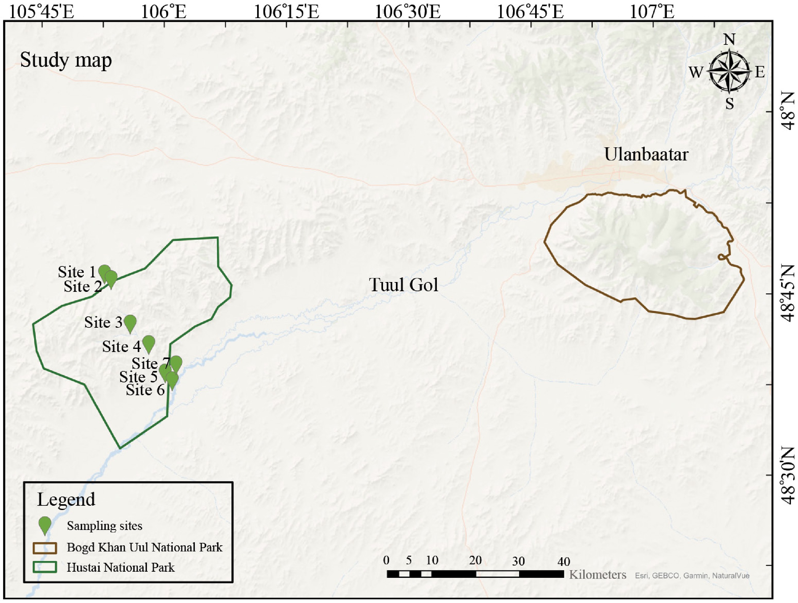
Figure 1.
Sampling map of Hustai National Park (HNP), and its surrounding areas. Bogd Khan Uul National Park (BKU) is included as the control site for Normalized Difference Vegetation Index (NDVI) analysis. Soil and plant samples were collected exclusively from HNP. The study includes a total of 10 sampling sites (S1 to S7), with additional sub-sampling locations at sites S2, S3, and S4. These sub-sampling sites are categorized based on their position relative to the fence (see Supplementary Table S2).
-
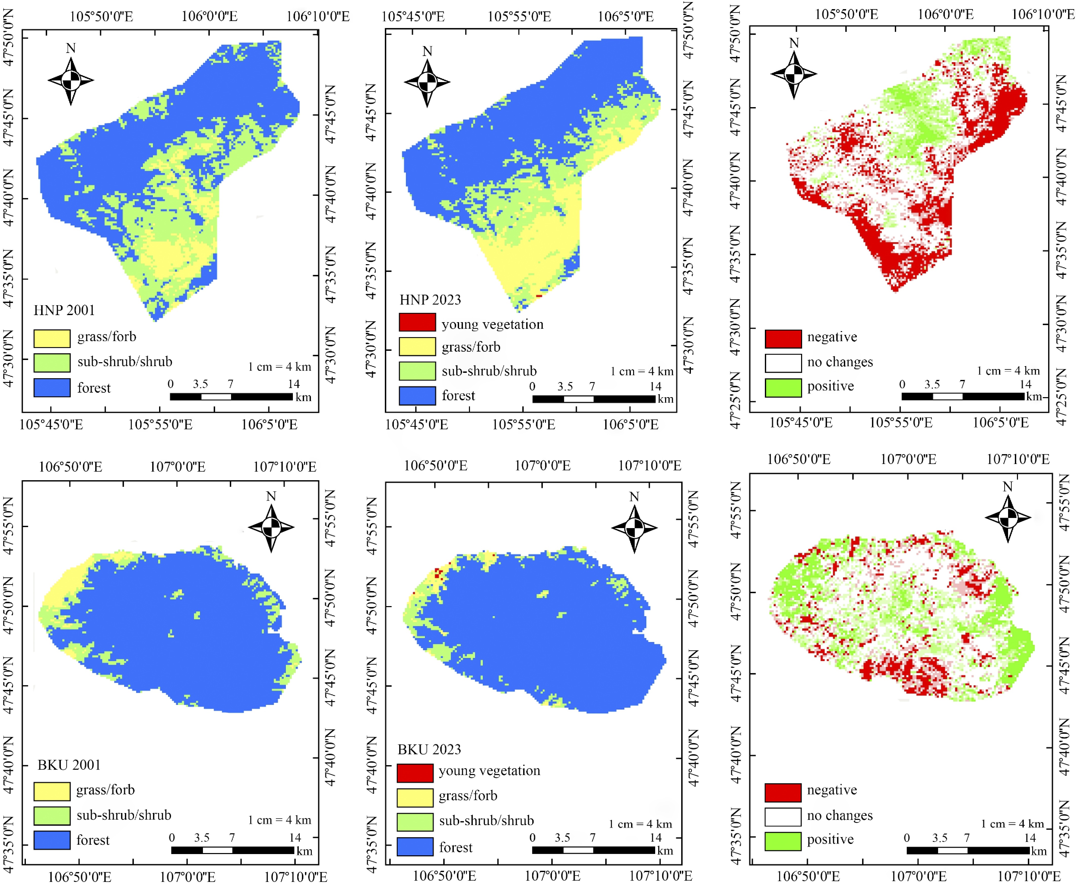
Figure 2.
Spatial distribution of Normalized Difference Vegetation Index (NDVI) in Hustai National Park (HNP) and Bogd Khan Uul National Park (BKU) for July 2000 (left) and July 2023 (middle). NDVI values are categorized as follows: > 0.6 for forest, 0.4–0.5 for subshrubs/shrubs, 0.3–0.4 for grass/forbs, and > 0.2 for young vegetation. The corresponding changes in NDVI between 2001 and 2023 are shown on the right, where negative values indicate vegetation loss, a value of 0 represents no change, and positive values indicate vegetation expansion.
-
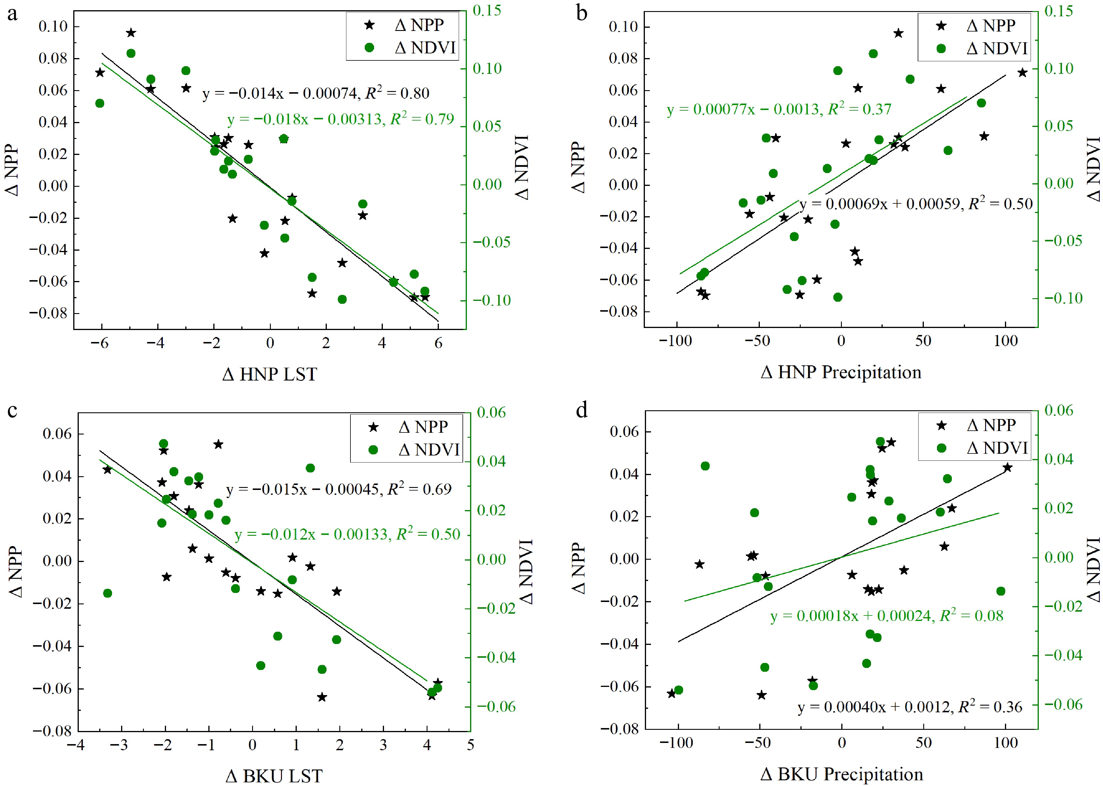
Figure 3.
Interannual variation in LST and precipitation and their effects on net primary productivity (NPP) and Normalized Difference Vegetation Index (NDVI) in Hustai National Park (HNP) and Bogd Khan Uul National Park (BKU) during the growing season (May to August) from 2001 to 2021. (a) LST in HNP, (b) precipitation in HNP, (c) LST in BKU, and (d) precipitation in BKU.
-
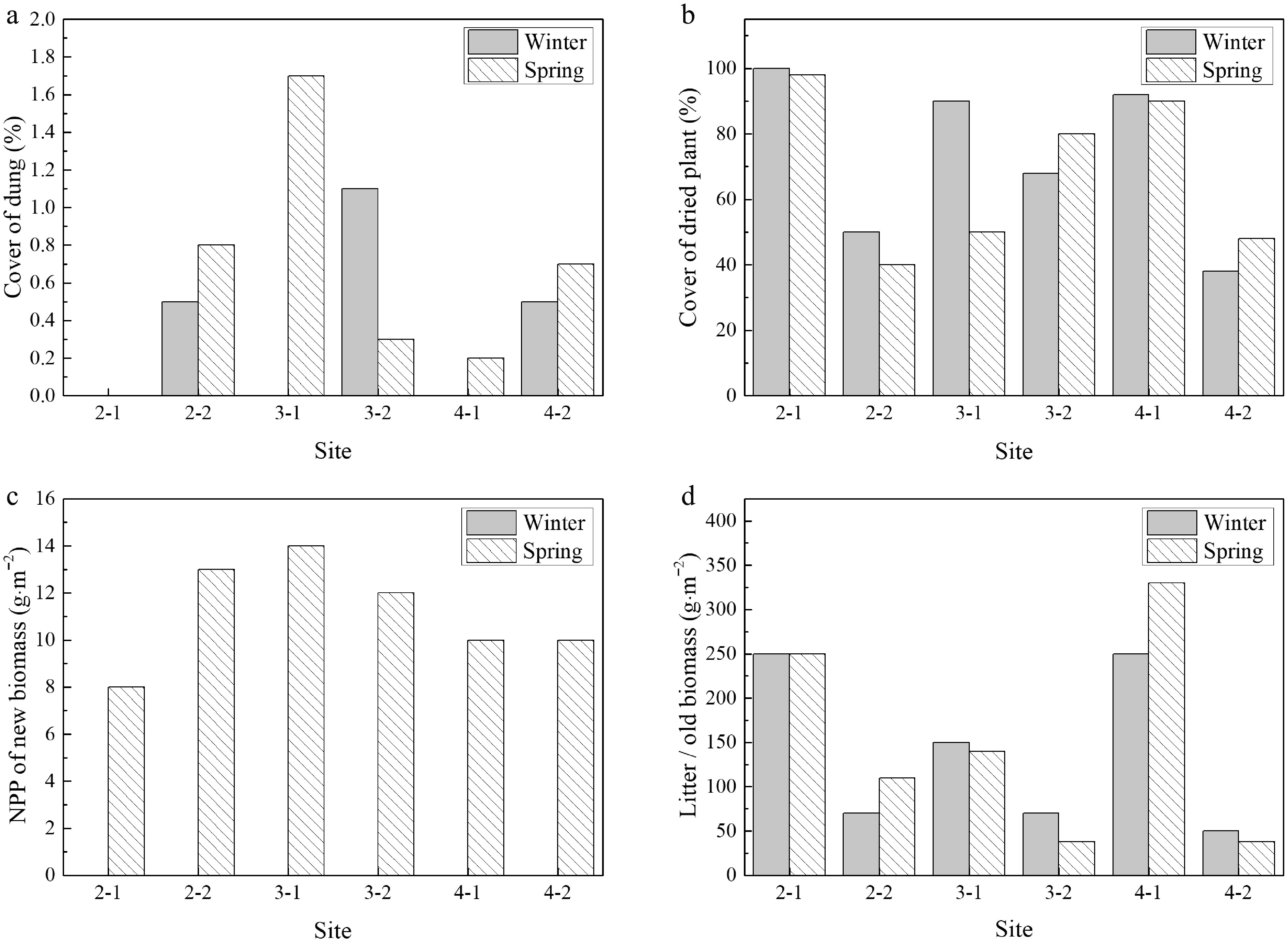
Figure 4.
Seasonal effects of grazing on vegetation structure and biomass. Comparisons between fenced (ungrazed) and unfenced (grazed) plots during winter and spring for (a) dung cover (%), (b) dried plant cover (%), (c) net primary production (g·m−2), and (d) litter/old biomass (g·m−2). The site ending with '−2' indicates a grazing site.
-
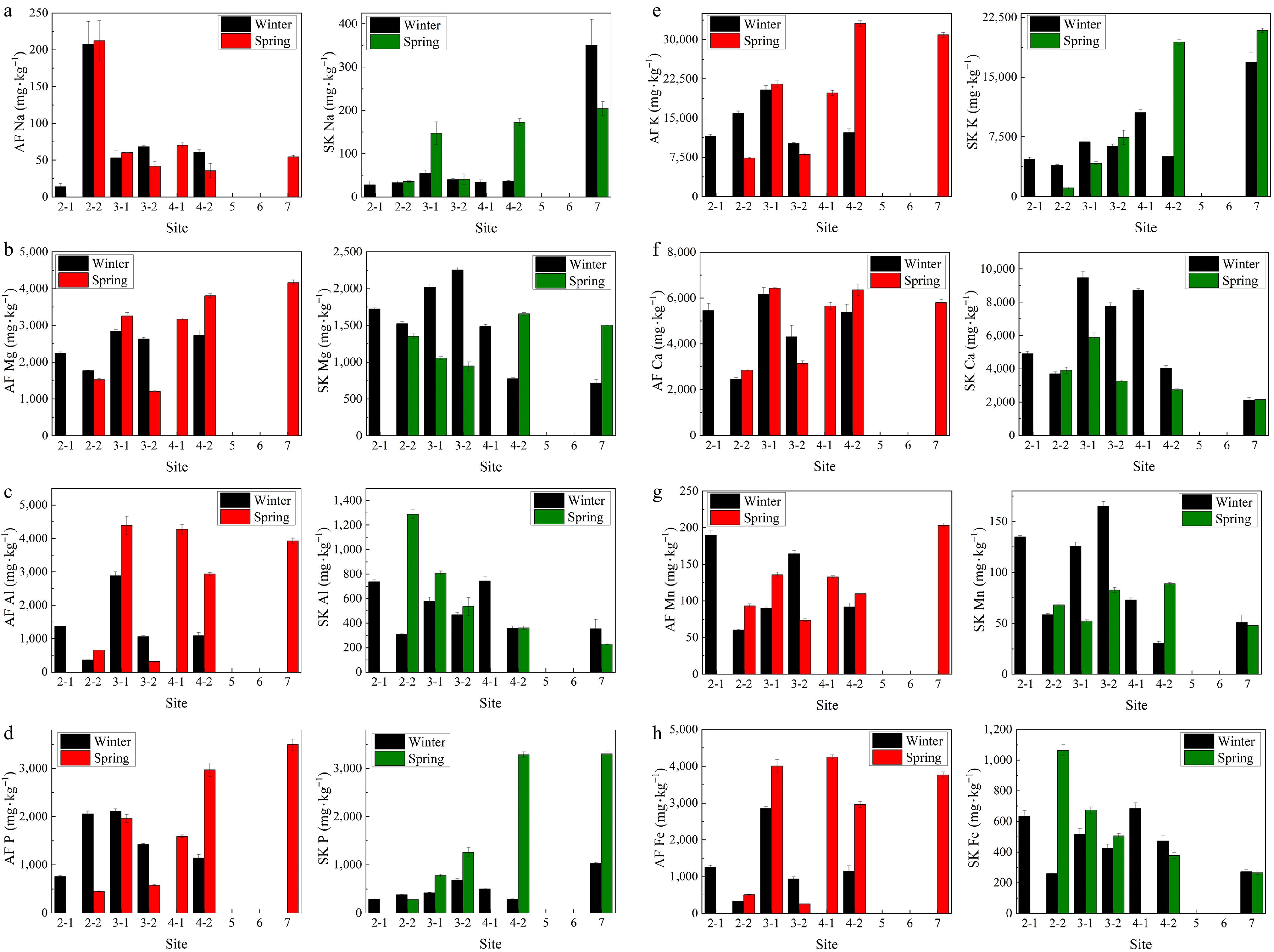
Figure 5.
Concentration of major elements (in mg·kg−1) in Artemisia frigida (red) and Stipa krylovii (green) in Hustai National Park (HNP), Mongolia, during winter and spring for (a) sodium Na, (b) magnesium Mg, (c) aluminium Al, (d) phosphorus P, (e) potassium, K (f) calcium Ca, (g) manganese Mn, and (h) iron Fe.
-
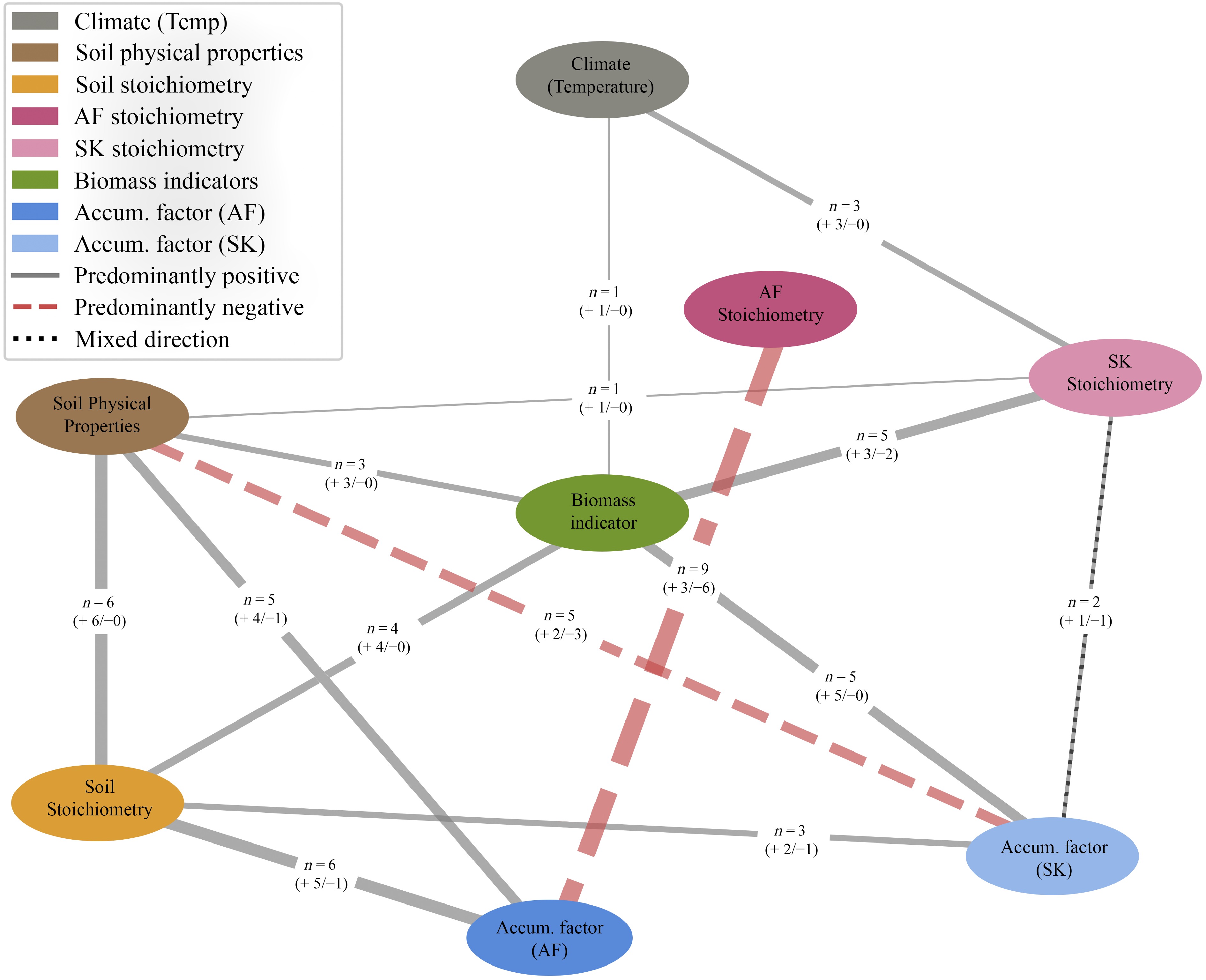
Figure 6.
Simplified soil-plant-climate network diagram derived from significant Spearman's rank correlation coefficients for Artemisia frigida (AF) and Stipa krylovii (SK). Each node represents a variable group whose components are detailed in Supplementary Tables S11, S12. Precipitation was excluded due to its perfect inverse correlation with temperature (ρ = −1.00). Only correlations with |ρ| ≥ 0.5 and p < 0.05 are shown. Edge width is proportional to the number of significant variable pairs (n) between node groups, with solid and dashed lines indicating predominantly positive and negative correlations, respectively.
-
Characteristic Hustai National Park (HNP) Bogd Khan Uul National Park (BKU) Distance apart 100 km southwest of Ulaanbaatar, Mongolia 30−40 km south part of Ulanbaatar, Mongolia Area 506.2 km2 422.7 km2 Elevation 1,400−1,843 m[21] 2,268 m above sea level[22] Mean annual temperature 0.2 °C −0.5 °C Annual precipitation 222.5 mm (1996−2010)[23] 268.5 mm (1999−2018)[24] Dominant ecosystem Area consists primarily of grassland and shrubland (88%), with 5% forest cover, and includes mountain and forest steppes Typical mountainous forest-steppe with the 53.2% of the area covered by forest steppes[22] Protection status Protected zone to conserve the endangered Przewalski's horse (Equus ferus przewalskii) since 1993 Strictly protected area since 1778 Historical land use Former agriculture, including crop and livestock production[25] Minimal Protection zoning Protected area established for conservation of Przewalski's horses Divided into restricted (12,216 ha), protected (13,433 ha), and pristine (16,000 ha)
*Remaining area is covered by pastureland (20,278 ha) and 1,754 ha for the citizens and businesses[26]Dominant vegetation types 208 species of nonvascular plants and 451 species of vascular plants[27]
Note: The formerly cultivated land was dominated by plant species such as Artemisia macrocephala, A. scoparia, A. commutata, and A. pectinata; original mountain steppe vegetation consisted primarily of Agropyron repens, Agropyron cristatum, Stipa krylovii, Carex duriuscula, and Kochia prostrata[25]746 species of vascular plants and predominant of larch and birch trees, rich pine foests, and spruce forests[24] Herbivore populations 1,300 red deer, 500 Mongolian gazelles, and 330 Przewalski's horses[20] Musk deer and sable[24] Grazing pressure High Low Fenced Installed 2018 (UNU Land Restoration Training Programme) None Table 1.
Summary of environmental characteristics of the Hustai National Park and Bogd Khan Uul National Park highlighting their climatic similarity and contrasting grazing regimes.
-
Correlativity HNP NDVI BKU NDVI HNP NPP BKU NPP Day time LST −0.89 −0.72 −0.89 −0.84 Precipitation 0.61 0.29 0.70 0.60 Table 2.
Correlation coefficients of Normalized Difference Vegetation Index (NDVI) and Net Primary Productivity (NPP) during the growing season in response to daytime Land Surface Temperature (LST) and precipitation in Hustai National Park (HNP) and Bogd Khan Uul National Park (BKU).
-
Site Winter Spring N (%) C (%) H (%) P (%) C : N ratio N (%) C (%) H (%) P (%) C : N ratio A. frigida 2-1 0.55 43.57 6.42 0.08 78.79 − − − − − 2-2 0.88 45.69 6.48 0.21 51.74 0.41 45.66 6.41 0.04 110.47 3-1 1.02 42.47 6.28 0.21 41.64 1.11 42.58 6.35 0.20 38.47 3-2 0.76 45.68 6.27 0.14 60.11 0.41 46.34 6.54 0.06 113.95 4-1 − − − − − 0.67 43.07 6.20 0.16 63.97 4-2 0.63 44.16 6.30 0.11 69.76 1.23 43.63 6.43 0.30 35.47 7 − − − − − 1.92 42.25 6.33 0.35 22.04 S. krylovii 2-1 0.47 41.66 6.00 0.03 89.20 − − − − − 2-2 0.40 44.32 6.14 0.04 111.63 0.49 43.81 6.49 0.03 88.81 3-1 0.60 42.36 6.13 0.04 70.95 0.85 43.92 6.39 0.08 51.88 3-2 0.82 42.25 5.97 0.07 51.71 1.27 43.92 6.47 0.13 34.67 4-1 0.54 42.18 5.86 0.05 77.69 − − − − − 4-2 0.46 43.84 5.96 0.03 95.31 2.35 44.79 6.46 0.33 19.09 7 0.42 42.49 6.13 0.10 100.46 2.91 45.29 6.76 0.33 15.55 N, nitrogen; C, carbon; H, hydrogen; P, phosphorus. Table 3.
The average content of elements (%) in plants of Hustai National Park (HNP), Mongolia.
Figures
(6)
Tables
(3)