-
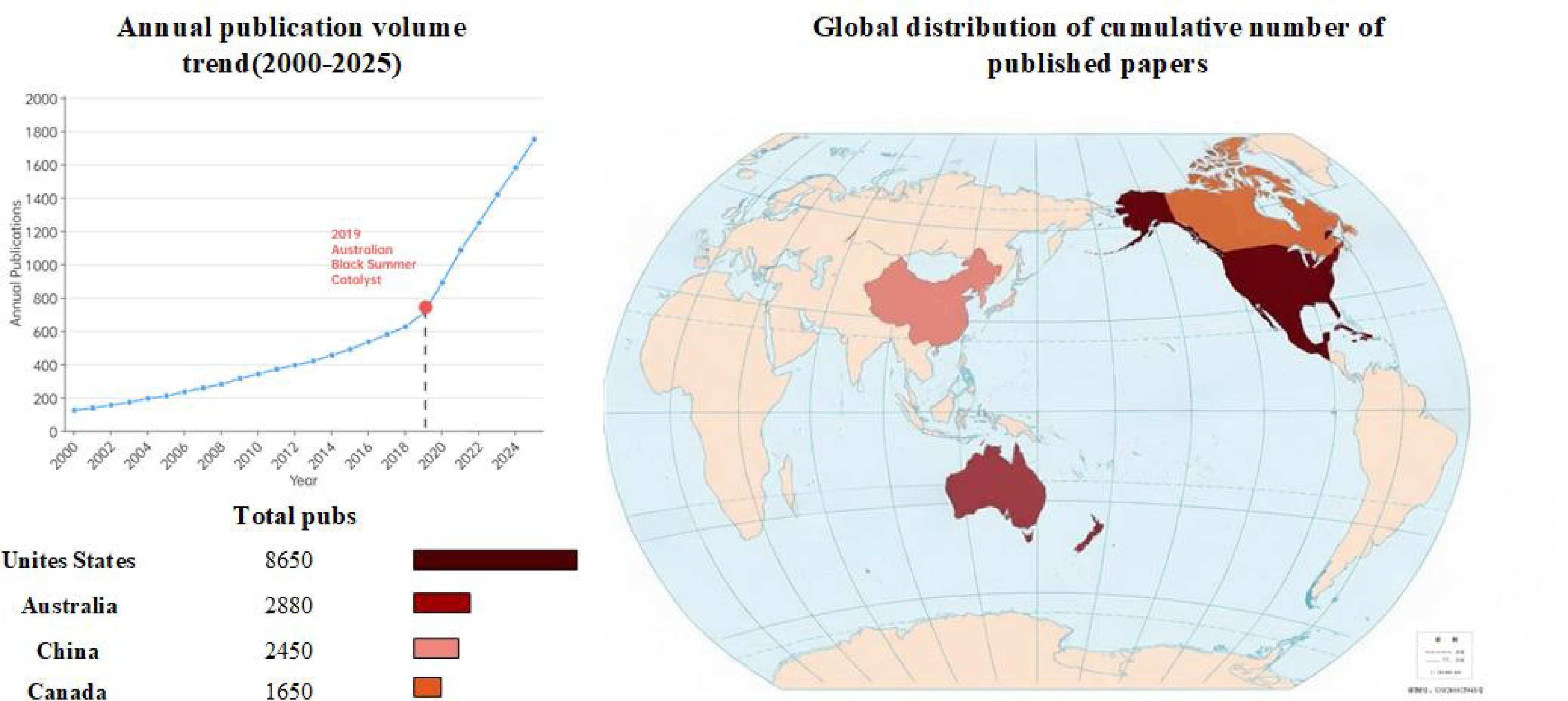
Figure 1.
Trend of global prescribed burning research publications and geographical distribution characteristics, 2000–2025.
-
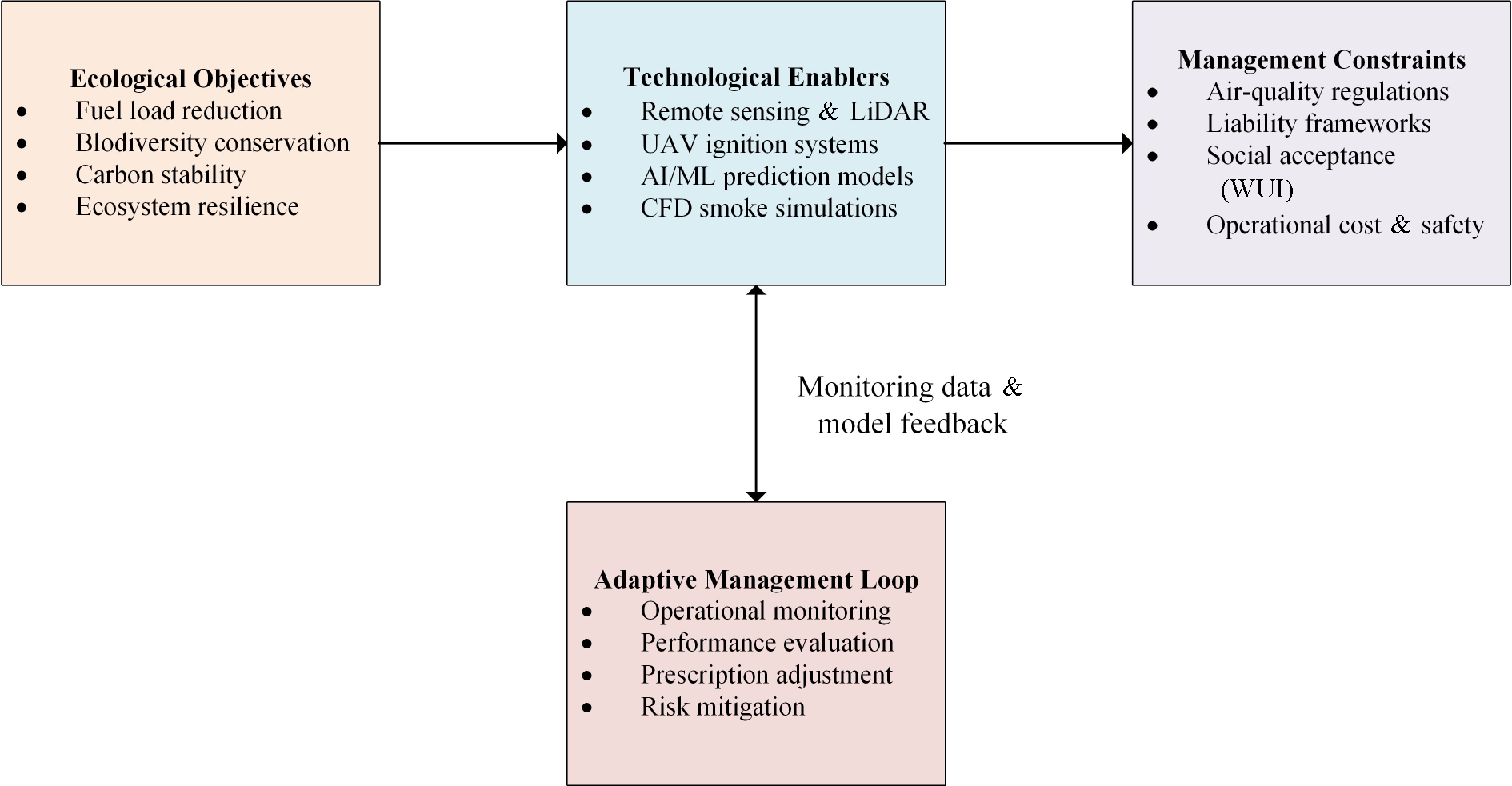
Figure 2.
Conceptual framework of prescribed burning management.
-
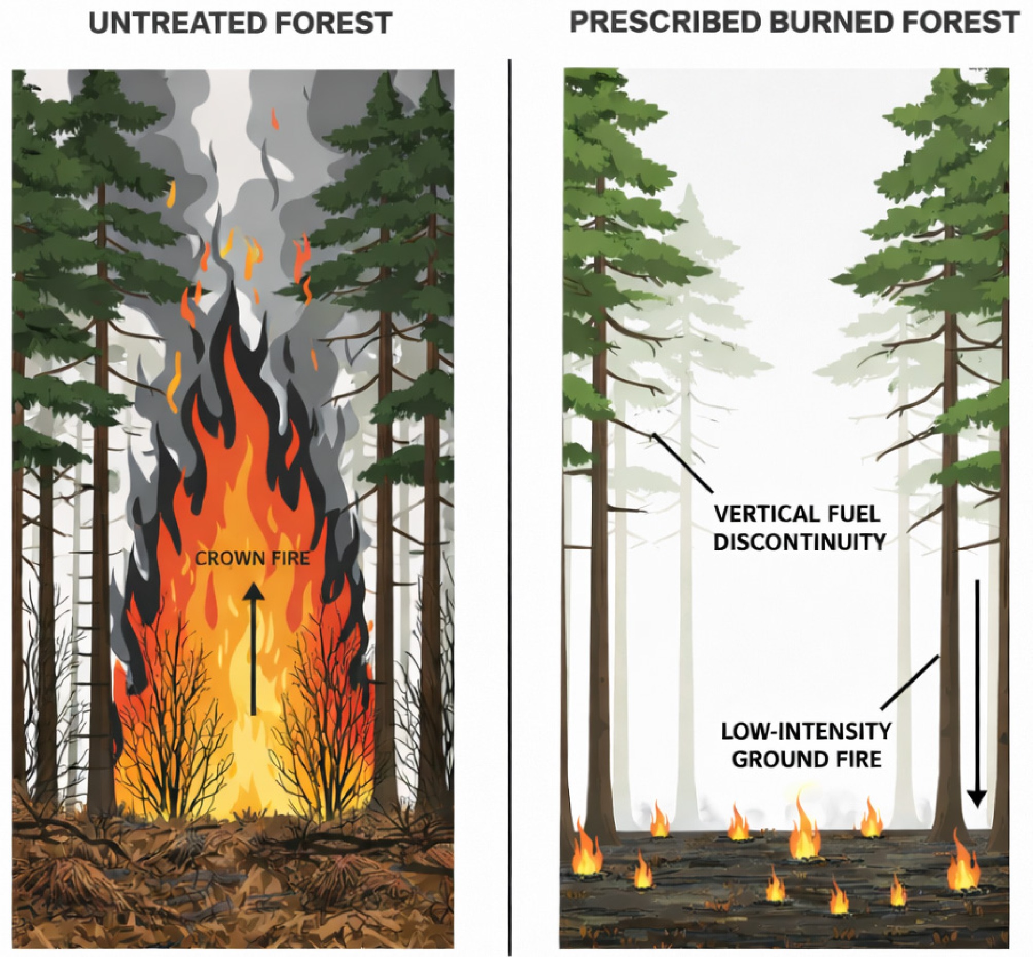
Figure 3.
Mechanism of prescribed burning's impact on forest vertical structure and potential fire behavior.
-
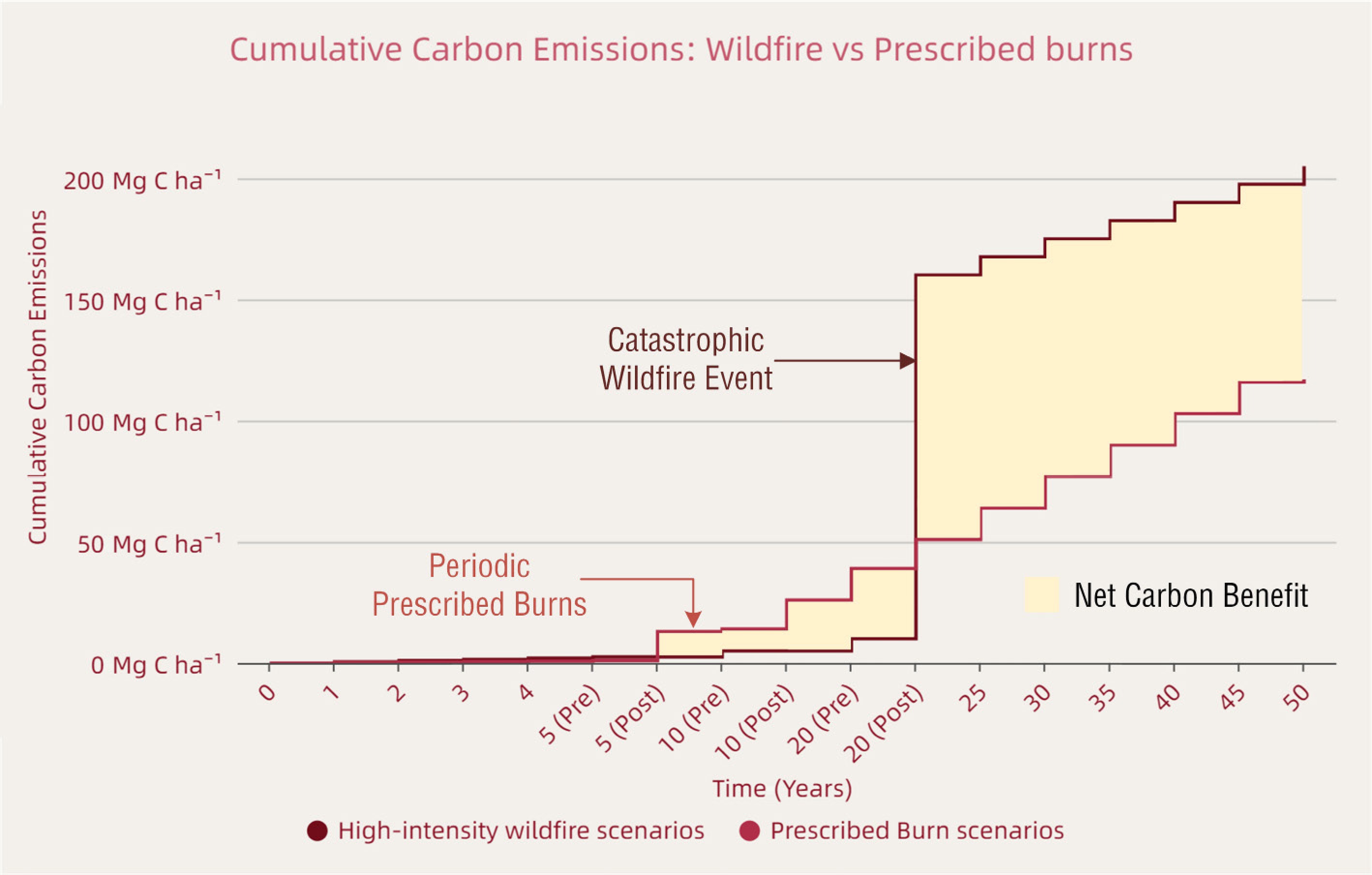
Figure 4.
Full life-cycle carbon emission simulation comparison between prescribed burning and high-intensity wildfires.
-
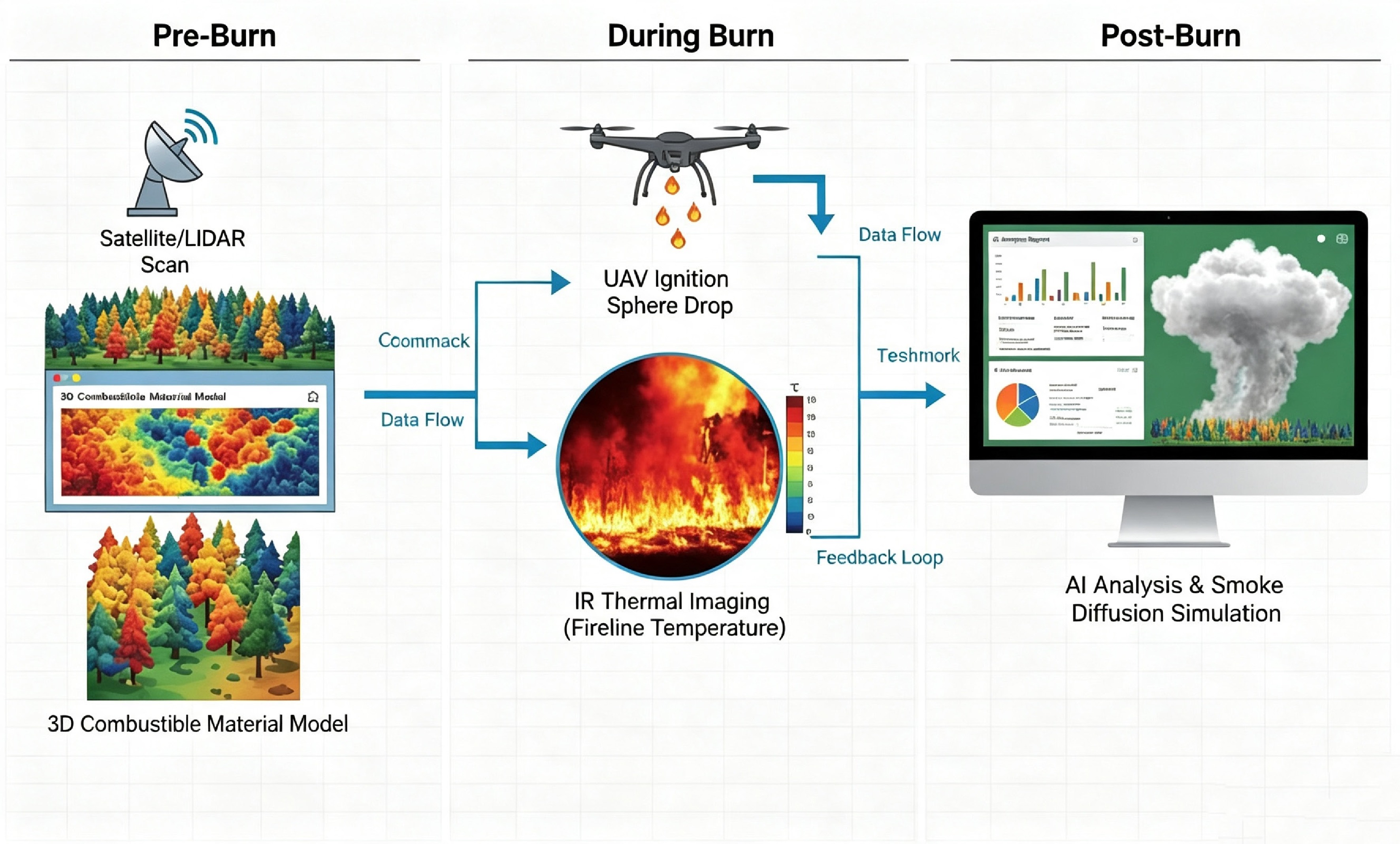
Figure 5.
Smart prescribed burning workflow based on digital twins and human-machine collaboration.
-
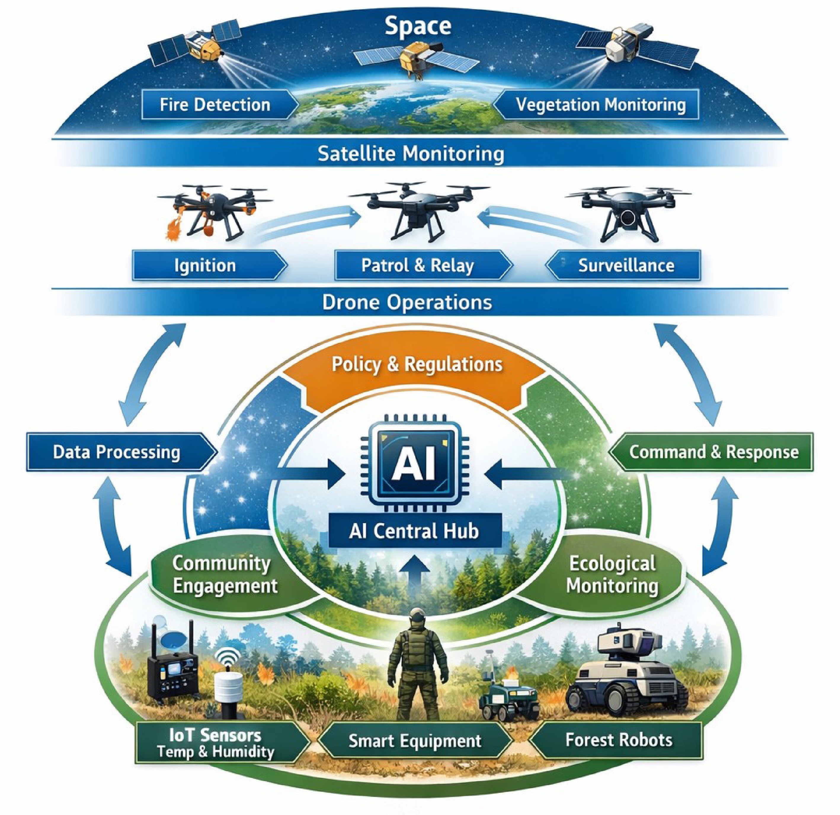
Figure 6.
Architecture of the future 'Space-Air-Ground' integrated smart forest fire management system.
-
Sensor/platform Main outputs Strengths Limitations Best-use cases UAV RGB Perimeter, flame geometry, visual smoke plume High spatial detail; flexible viewpoints Smoke occlusion; daylight dependent Ignition quality control; mapping burn perimeter UAV thermal IR (TIR) Hotspots, temperature proxies Penetrates smoke; night
capableRadiometric calibration; limited flight endurance Spot-fire detection; mop-up; safety monitoring Ground IoT (met, PM sensors) Wind/RH; fuel moisture;
PM2.5 near receptorsContinuous; direct exposure measurement Sparse coverage; maintenance burden Go/no-go thresholding; compliance reporting Satellite (VIIRS/MODIS/Sentinel) Hotspots, burn scars,
aerosols (coarse)Large-area context; historical baselines Revisit/cloud limits; coarse resolution Regional awareness; post-burn severity mapping Handheld IR/crew sensors Local hotspots, intensity proxies Low cost; immediate tactical feedback Labor intensive; limited coverage Fine-scale verification during operations Table 1.
Comparison of monitoring sensors for prescribed burning operations.
-
Dataset Modalities Scenario and scale Annotations/tasks Ref. FLAME RGB video + thermal heatmaps UAV imagery over a prescribed pile burn (Arizona, US) Frame-level classification; fire segmentation masks Shamsoshoara et al.[31] FLAME 3 RGB + radiometric thermal (TIFF) UAV wildland-fire imagery with radiometric thermal products Detection/segmentation; thermal calibration Hopkins et al.[32] UAV-strawFire RGB + thermal IR + video Controlled residue/straw burning (southern China) Detection, segmentation, tracking baselines Hu et al.[33] Table 2.
Representative open datasets for AI-enabled fire/flame/smoke monitoring.
-
Tool Typical scale/use Key inputs Strengths Limitations HYSPLIT Regional transport/screening Meteorology, emission rate, release height Fast; widely used; trajectory/dispersion screening Simplified plume rise; limited near-field complexity CALPUFF Local–regional, complex terrain Meteorology, terrain, emissions Terrain handling; regulatory use
in some settingsParameter sensitive; simplified chemistry; setup effort WRF-chem/
CMAQRegional air-quality planning Emissions inventory, chemistry, meteorology Coupled chemistry; PM2.5/ozone impacts High computational cost; coarse for near-field burns WFDS/FDS Near-field flow/smoke in constrained domains Heat release, geometry, wind High-fidelity flow/heat; near-field scenarios Domain-limited; heavy compute; not regional QUIC-fire Operational CFD fire–
atmosphereFuel, wind, terrain, ignition pattern Fast CFD-style simulation; complex terrain support Needs calibration; emissions/fuels uncertainty Table 3.
Comparison of commonly used smoke/fire–atmosphere modeling tools for prescribed burning.
-
Dimension North America/Australia (mature system) China (transition phase) Primary driver Dual-drive (ecology and risk)
Views fire as an ecological process; emphasizes fuel reduction and habitat restoration.Safety-dominant (prevention)
Focuses on firebreaks and risk reduction; gradually extending to ecological restoration.Legal liability Negligence liability
Certified practitioners following prescriptions are generally
immune from liability (Safe Harbor principle).Strict liability
Result-oriented accountability; accidental escapes often lead to severe penalties regardless of intent.Decision & personnel Professional certification
Mandatory Certified Burn Manager (CBM) credentialing is administered by state/agency fire and land-management authorities. Training covers fire behavior–weather, fuels and burn prescriptions, ignition operations, smoke/air-quality compliance, risk & safety management; certification typically requires coursework plus mentored burns, competency sign-off, and periodic recertification.Administrative command
Establish a forestry and fire-authority–led Certified Burn Manager framework with tiered roles; standardize curricula; require coursework plus mentored burns with task-book/logbook documentation; competency sign-off; periodic recertification/CPDKey technology Data-driven and aerial
Widespread use of aerial ignition (PSD), fire behavior modeling,
and smoke dispersion simulation.Labor-intensive
Relies on manual drip torches and blowers; UAVs and digital twins are in pilot stages.Major challenges Social acceptance
Public intolerance to smoke (NIMBY effect) and constraints in Wildland-Urban Interface (WUI) areas.Fragmented tenure and terrain
Steep terrain, high population density, and fragmented forest tenure hinder unified operations.Table 4.
Comparison of prescribed burning management modes and characteristics between China and major western countries.
-
Ecosystem/region Main objectives Regulatory and institutional context Typical techniques and tools Boreal forests (Canada/Alaska) Fuel reduction near communities; protect timber assets Agency-led planning; smoke management permits; burn boss/crew qualifications Spring/fall low–moderate intensity; aerial ignition in remote areas; satellite + ground severity plots Savannas (Northern Australia) Early dry-season mosaic burning; biodiversity and emissions reduction Indigenous ranger programs; carbon-credit methodologies in some regions Frequent low-intensity burns; ignition by drip torch/heli/PSD; monitoring with burn-scar maps and emissions accounting Mediterranean forests (Southern Europe) Maintain fuel breaks; reduce crown-fire potential; WUI protection Highly regulated due to smoke and liability; narrow burn windows Small-block burns; mechanical prep + backing fires; smoke forecasting and rapid mop-up Chaparral/WUI (Western
North America)Hazard reduction; create defensible space; ecosystem restoration Public communication and air-quality coordination are central Targeted burns under dispersion constraints; sensors + handheld IR; post-burn risk scoring Subtropical plantations
(South China, pilots)Fuel reduction; pest/disease control; site preparation Pilot programs with administrative approval; evolving standards Small-area burns; UAV reconnaissance/
thermal imaging; local fuel models under developmentTable 5.
Representative prescribed-burning practices across ecosystems and regions.
Figures
(6)
Tables
(5)