


-
Governments invest in early warning systems (EWS) with the understanding that it allows communities at-risk to evacuate during disasters, and subsequently save their lives and livelihoods. In 2022, about 60% of the countries in Asia and the Pacific region reported having multi-hazard early warning systems, which is a significant improvement compared to only 25% in 2015[1]. In most countries, the EWS depend on ground-based telecommunication facilities (e.g., telephones, Wi-Fi, radios, mobile phones, and related devices) to disseminate the warning information[2]. While many successful evacuations are reported after the communities at-risk received an early warning information through mobile notifications[3], this is not often the case in areas that have limited or no coverage of internet or cellular communication systems. Moreover, when the ground communication infrastructures are damaged due to extreme events, the communities at-risk cannot receive the early warning message.
During the Hunga Tonga-Hunga Ha'apai submarine volcanic eruption and tsunami in Tonga on 14 January 2022, the tsunami early warning system did not work since the undersea fiber-optic cable that connects Tonga to the rest of the world was ruptured[4]. It affected thousands of people, and it incurred severe damage on homes, businesses, and major resorts[5]. Another instance was during the occurrence of the 7.4 magnitude earthquake, which triggered a tsunami, in South Sulawesi, Indonesia on 28 September 2018. The government's tsunami warning systems (InaTEWS) failed to deliver the warning information to the communities at-risk in Palu City due to the bureaucratic and long process of information dissemination that resulted in the loss of the lives of 3,879 people[6]. When the earthquake occurred, the Meteorology, Climatology, and Geophysical Agency (BMKG) communicated a tsunami early warning to the Komando Pengendalian (or Kodal, i.e., local government) in the area to get approval for the warning information to be delivered to the communities at-risk. Based on existing protocol, the Governor of the Kodal must organize a meeting with the Deputy Governor, the Military Commander (Pangdam), the Chief of Police (Kapolda), and other members to agree on the course of action before activating the warning procedure, including the sirens. Consequently, the warning information did not reach the community at-risk and the EWS failed. Indeed, there are challenges in disseminating early warning information. Even sophisticated ground-based telecommunications systems do not guarantee effective dissemination of warning information, especially during extreme disaster events where networks can be disrupted or overloaded[7].
To augment the ground-based telecommunications, the Global Navigation Satellite System (GNSS) has been utilized for disaster early warning[8]. A key feature of GNSS is that it provides positioning information to anyone through cellular phones or exclusive devices. One example of GNSS is the Global Positioning System (GPS) owned by the United States. While the original purpose of GPS is to allow ships and aircraft to know their accurate position on the ocean or in the air, nowadays, it is also utilized for other purposes, such as car navigation, tracking personal movement, mapping, and disaster early warning[9]. Another example of GNSS is the 'Michibiki' otherwise known as the Quasi-Zenith Satellite System (QZSS) owned by Japan. One of the services under QZSS is transmitting short messages to a device via audio and/or display for disaster early warning. This service is known as QZSS early warning service or QZSS-EWS. With this service, end-users can receive emergency information from the satellite to their devices[10,11].
Use of satellites to augment ground-based early warning systems
-
In Japan, the QZSS-EWS is called Satellite Report for Disaster and Crisis Management (DC Report). The DC Report service started operating in Japan in November 2018 by transmitting short warning messages about the occurrence of natural hazards, such as earthquake and tsunami, to the devices on the ground. When the message is received on the earth's surface, it can be sent over to mobile phones, street lights, car navigation systems, and other terminals[10]. Since the message is transmitted via satellites, the end-users can receive it in real-time and in their current location, allowing emergency evacuation or self-help during disasters.
Operationalization in Japan
-
QZSS-EWS operates domestically with the Ministry of Land, Infrastructure, Transport and Tourism (MLIT) facilitating the satellite control station on the ground[12]. In an event of impending emergency, an agency (e.g., Japan Meteorological Agency) under MLIT creates emergency information using codes and transmits it to the QZSS satellite channel. From the satellite channel, end-users can receive the early warning message in a two-step approach. In Step 1, the message is transmitted to the receiver/device (portable or stationary). Those who have exclusive devices at hand (e.g., mobile phones or car/boat navigation dashboards) will directly receive the message via audio or visual display. In Step 2, the receiver/device can further send the message through Low Power Wide Area Networks (LPWAN) that activate horn speakers, sirens, electronic signboards, and beacon lights in public areas. So, even those who do not have the receiver/device at hand can be alerted of the emergency warning (Fig. 1).
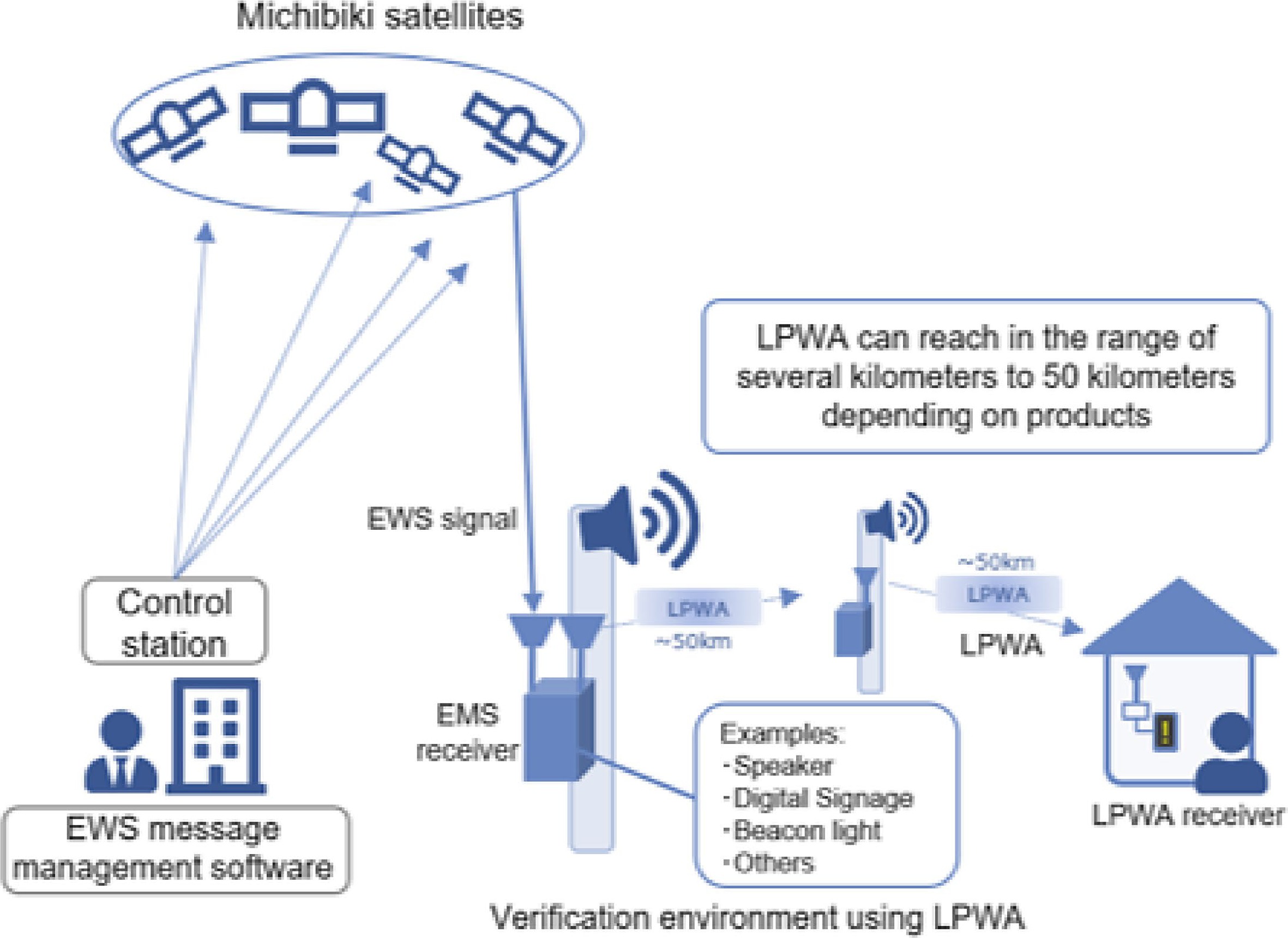
Figure 1.
Operationalization of QZSS-EWS[12].
Operationalization overseas
-
In 2024, the QZSS-EWS will be available to countries in the Asia-Pacific region. In implementing this, the location of the main satellite control station will be in Japan and the two-step approach of disseminating the warning message will be adopted. In preparation for the operationalization of the QZSS-EWS in other countries, the National Space Policy Secretariat of the Cabinet Office Japan (NSPS) is coordinating the following activities: (1) enhancement of system facility to receive messages from overseas organizations, as messages need to pass through the control station in Japan; (2) demonstrations in target countries to detect optimum system configuration of terminals, receivers, and ground segments; and (3) conduct surveys and feasibility studies[13].
Aim and objectives
-
This paper aims to understand the challenges in disseminating early warning information, and how it hinders community evacuation in the event of a disaster. It intends to achieve two specific objectives:
• Investigate the challenges in early warning that the communities have experienced
• Investigate the procedures of creating and disseminating early warning information
Results of this paper will offer insights in addressing the challenges in disseminating early warning information through the utilization of satellites. It will also contribute to improving the procedures for safe evacuation in the event of a disaster.
-
To achieve the objectives, the authors, who are both members of the Japan Team to implement the QZSS-EWS demonstrations in other countries, collected the materials through the following methods: 1) accessing information shared by members of the Japan Team, particularly from NSPS, NTT Data, Asia Air Survey, and Asian Disaster Reduction Center or ADRC; 2) administering a survey to disaster risk reduction (DRR) experts from ADRC member countries; and 3) conducting a desk review by searching relevant materials available on the internet.
Among the materials that the authors accessed from the Japan Team include initial findings of the feasibility studies that the Asia Air Survey conducted in 25 target countries in the Asia-Pacific region. The initial findings offer information about the common challenges in early warning information dissemination in 10 of the 25 target countries. The common challenges are: lack of robustness, lack of immediacy, lack of correctness, and lack of comprehensiveness in the early warning systems. In addition, the authors conducted a survey among DRR experts (comprising former visiting researchers at ADRC) from the 10 target countries to know the specific challenges in early warning in their respective communities based on past experiences. Some questions of the survey were intended to draw the respondents' views on disaster communications system and their thoughts on using the satellites to augment the existing early warning systems. Compared with other countries, Bangladesh, Bhutan, and Mongolia showed greater challenges in early warning dissemination due to a range of factors, including topography and the type of hazards. To further validate and support the initial findings, the authors also conducted a desk review to understand the key features of QZSS-EWS, get oriented with the disaster risk management (DRM) systems, and gain perspectives of the early warning practices of the communities in Bangladesh, Bhutan, and Mongolia.
Based on the Japan experience[9], the authors noted the following key contributions of QZSS-EWS: (1) it serves as redundant system in case the ground-based telecommunications system is disrupted by a large-scale event; (2) it is most useful in areas that have limited or no internet/cellular communication systems; and (3) it augments existing early warning systems by transmitting the warning information in real-time, hence, avoiding delay or distortion of the warning message. These contributions are the main considerations in analyzing whether the three target countries should introduce the QZSS-EWS.
-
This section presents the challenges of disseminating disaster early warning information to communities at-risk in different local environments and different types of hazards. It particularly presents the early warning systems in: 1) coastal communities of Bangladesh that are prone to tropical cyclone; 2) communities of Bhutan Himalayas that are prone to glacial lake flood outburst (GLOF); and 3) herder communities of Mongolia that are prone to dzud.
Tropical cyclone warning in Bangladesh
-
Due to its geographical condition as a low-lying country, Bangladesh experiences tropical cyclones with an average of 17 occurrences every year that often impacted fisherfolks and farmers[14]. Following the tragic experience from Cyclone Bhola on 12 November 1970 that caused the loss of lives of about 500,000 people, the Government of Bangladesh has been introducing disaster risk reduction (DRR) measures, including early warning systems, to prevent such large-scale disaster from reoccurring[15]. The government also learns from other past experiences so that communities can prepare and appropriately respond to future cyclone disasters.
Challenges in early warning as experienced by the communities
-
Impacts of tropical cyclones are exacerbated when communities do not receive timely and actionable early warning information. In Bangladesh, a range of factors are attributed to this. First, lack of access to media. While broadcast media, newspapers, and websites could be effective in disseminating cyclone warnings, most coastal communities lack access to these channels. During cyclone Sidr of 2007, communities reported that they did not receive the warning information for the following reasons: (1) they live in remote areas that could not be reached by megaphones; (2) they did not have access to radio/television; and (3) they live in remote areas without media[14]. Second, insufficient warning information. Even if the communities could receive the warning information, if it is insufficient, this could lead to confusion. Rahman mentioned three examples to show why the warning information is insufficient[17]. (1) The weather bulletin, which the government authority issues, usually describes the path of the cyclone by focusing on the nearest seaport (e.g., 'the cyclone is located 50 km southeast of Chittagong port'). This is an old-fashion approach of warning that was introduced by the British Colonial Power way back in 1935 to protect ports instead of communities. (2) The Danger Warning Signals, which shows the scale between 1 and 10, are not understood by many community members since it is complicated to memorize. (3) The warning information is expressed in metric systems (e.g., 'flooding in the locality will likely increase by 20 centimeters in the next 24 hours') that people in the rural communities cannot relate to since very few have a formal education. Third, delayed arrival of warning information. Fishing communities reported that during the July 2018 cyclone, hundreds of fishermen, along with their fishing-boats, went missing in the Bay of Bengal due to the delay of disseminating the early warning information[16].
Early warning system for tropical cyclone
-
The Bangladesh Meteorological Department (BMD) is the lead agency for cyclone early warning. To facilitate cyclone forecasting, the Storm Warning Centre (SWC) of BMD obtains information from radar observations, satellite imagery, field observatories, and the Regional Specialized Meteorological Centre (RSMC) of New Delhi. After analyzing the information, SWC/BMD will then create an early warning message that will be disseminated to the media (i.e., television, radio, and newspaper) and to the Cyclone Preparedness Programme (CPP) – a unique institutional arrangement within the government for community preparedness, comprising over 74,000 volunteers[15,17]. When CPP receives the warning information, it will be forwarded to the Coastal Zonal Offices (CZO) at the district level, which will then forward it to the Upazila Disaster Management Committees (UzDMC) at the sub-district level, and down to the Union Disaster Management Committees (UDMC) at the lowest level. As the message reaches the lowest level, the CPP volunteers will disseminate the warning information to the neighborhoods by blowing of sirens, hoisting of flags, and announcement by megaphones (Fig. 2).
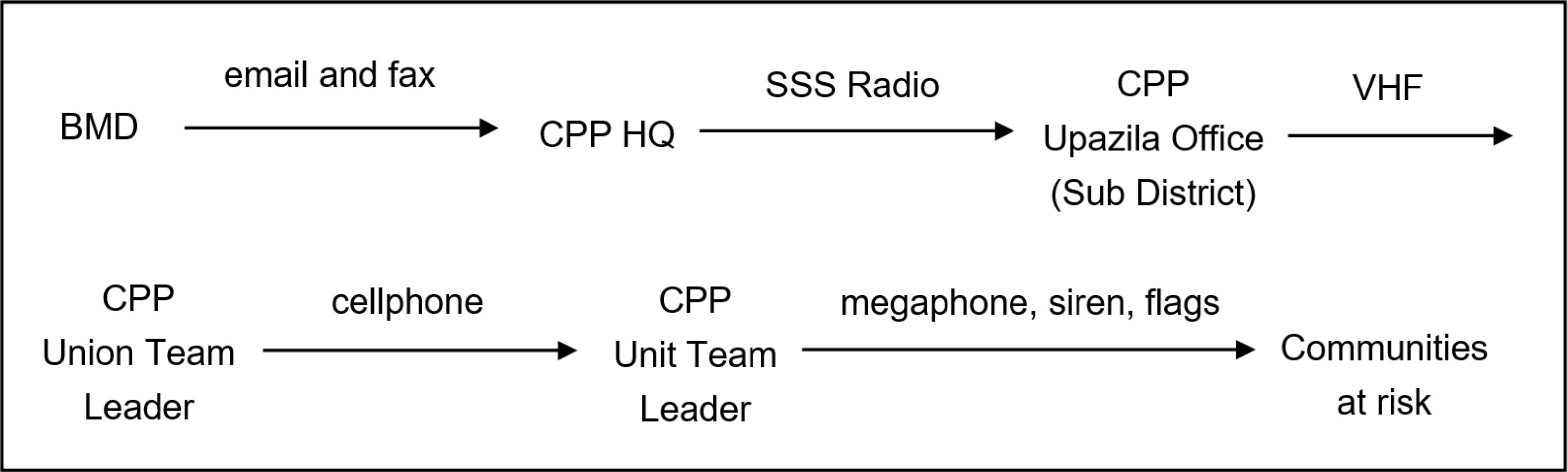
Figure 2.
Dissemination of warning messages for tropical cyclones in Bangladesh[17].
There are obvious limitations of the BMD's early warning system for tropical cyclones. In terms of creating the warning information, at least two limitations are observed. On one hand, the warning information uses technical terms that people in the communities don't understand, such as 'forecasted movement direction' and 'surge height'[18]. On the other hand, the accuracy of the warning information is poor. SWC/BMD often fails to correctly forecast the landfall trajectories of cyclones – a performance that is far behind compared to the National Hurricane Center (NHC) of the USA or the Japan Meteorological Agency (JMA), as both agencies have credible and reliable capacity in forecasting complex, rapidly-forming, and fluctuating tropical cyclones[16]. In terms of disseminating the warning information, the most notable limitations according to Rahman are: (1) there is a long chain of information flow that causes distortion or delay of warning message; and (2) communities can only receive the warning information from the CPP volunteers instead of getting it directly from the SWC/BMD[17].
While the BMD's early warning system for tropical cyclone has contributed in reducing the number of casualties in the past decade, it still has limitations in effectively disseminating the warning information to the communities at-risk. This is evident from the recent tropical cyclones like Sidr of 2007 and Aila of 2009 that severely impacted the lives and livelihoods of coastal communities. In fact, during the last three decades (1991-2021), Bangladesh recorded over 160,000 deaths from tropical cyclones[15]. In view of this, the BMD keeps improving the early warning system by strengthening the wireless communication at all levels as well as introducing the Interactive Voice Response (IVR) service, where communities can dial '10941' to receive daily weather forecast, including tropical cyclones[19].
Considerations for introducing QZSS-EWS
-
Lack of immediacy or delay of disseminating the warning information is one of the challenges in the EWS of Bangladesh. In the existing system, the CPP volunteers play a great role in disseminating the warning information by blowing of sirens, hoisting of flags, and announcement by megaphones. In other words, the community as-a-whole receives the warning information and not through a single individual. In this context, the introduction of the QZSS-EWS may be more effective if it is integrated in the CPP.
GLOF warning in Bhutan
-
Bhutan is a mountainous landscape exposed to high weather variability and extreme events, particularly glacial lake outburst floods (GLOFs). Since 70% of Bhutanese settlements are located along the river basins, most communities are exposed to GLOF and other hydro-meteorological hazards, including floods and landslides[20]. While many major GLOF events occurred in Bhutan in the past, the GLOF on 7 October 1994 caused the greatest impacts, prompting the government to establish an early warning system[21]. However, the limitations of that early warning system were revealed following the GLOF events that occurred on 28 June 2015 and on 20 June 2019 causing massive damage to infrastructure and livelihoods[22].
Challenges in early warning as experienced by the communities
-
Living in Bhutan Himalayas is considered a challenge due to the difficult terrains. On top of that, Bhutan has 677 glaciers and 2,674 glacial lakes that pose risk of flooding[23]. Under these topographical conditions, communities are not only scattered and remote, but they also have limited access to communication, transportation, and knowledge sharing. During the 1994 Lugge Tsho GLOF, Bhutan did not have a well-established early warning system, and it resulted in 22 people killed along with massive damage to properties, livestock, and agricultural lands[21]. To reduce risk, the Royal Government installed the first automatic GLOF early warning system with the support from UNDP, and later expanded with the support from the governments of Australia and Japan[24]. However, after experiencing subsequent GLOF events, the EWS did not effectively function in disseminating the warning information to the communities at-risk. Records between 1994 and 2011 showed that GLOF events caused 304 deaths and adversely affected the lives of approximately 87,370 people[20]. In the most recent GLOF events on 28 June 2015 and on 20 June 2019, massive damage to infrastructure and livelihoods were observed, further suggesting that the existing GLOF early warning system needs improvement[22].
The communities felt the limitations of the EWS as well as their own. According to Tshering[25], communities have limited access to communication technologies (e.g., radio, TV, and mobile phones) since the telecommunications infrastructure in Bhutan is still limited. In addition, members of the communities have no formal education, and therefore experiencing difficulties in reading, interpreting, and understanding the early warning information. While most people in the communities have experienced GLOF, they have limited knowledge about its causes and the unpredictability of its occurrence. These limitations are exacerbated since communities have no regular evacuation drills that facilitate skill transfer as well as enhance practical capacities to evacuate during actual disaster events[26].
GLOF early warning system
-
The National Center for Hydrology and Meteorology (NCHM) of the Royal Government of Bhutan is the lead agency for GLOF early warning system. Since installing the first early warning system in 1994, Bhutan Himalayas constantly experience climatic variabilities that is affecting the effectiveness of the system. In view of this, NCHM introduced improvements to the system, including the utilization of earth observation satellites[27]. The system has also been enhanced to adapt to the projected climatic changes[22]. Part of the enhancements is the installation of 10 Remote Automatic Water Level Stations (AWLS) and Automatic Weather Stations (AWS) as well as 18 sirens to warn vulnerable communities along the river valley downstream Punakha-Wangdue[24]. The main function of these remote stations is to monitor and detect GLOF in real-time. In producing the automatic alerts, data from the remote stations are transmitted to the Control Room using iridium satellite communication. These remote stations are linked to a network of sirens that are activated in the event of eminent GLOF threats (i.e., when water level reaches the Alarm Level). In addition, operators at the Control Room also monitor the latest data from the remote stations using customized software. So, if the water level reaches the point of the Alarm Level, the operators can activate the sirens manually. After activating the sirens, the Control Room operators will also disseminate the GLOF warning information to all relevant officials (Fig. 3):
• GLOF focal persons at the Department of Disaster Management, the Ministry of Home and Cultural Affairs, and the National Emergency Operation Centre
• Dzongkhag Disaster Focal Person, Dasho Dzongda, Dzongkhag Administration Gasa, Punakha, Wangdue, or Dzongkhag Emergency Operation Centre
• Focal person from Hydropower Plants
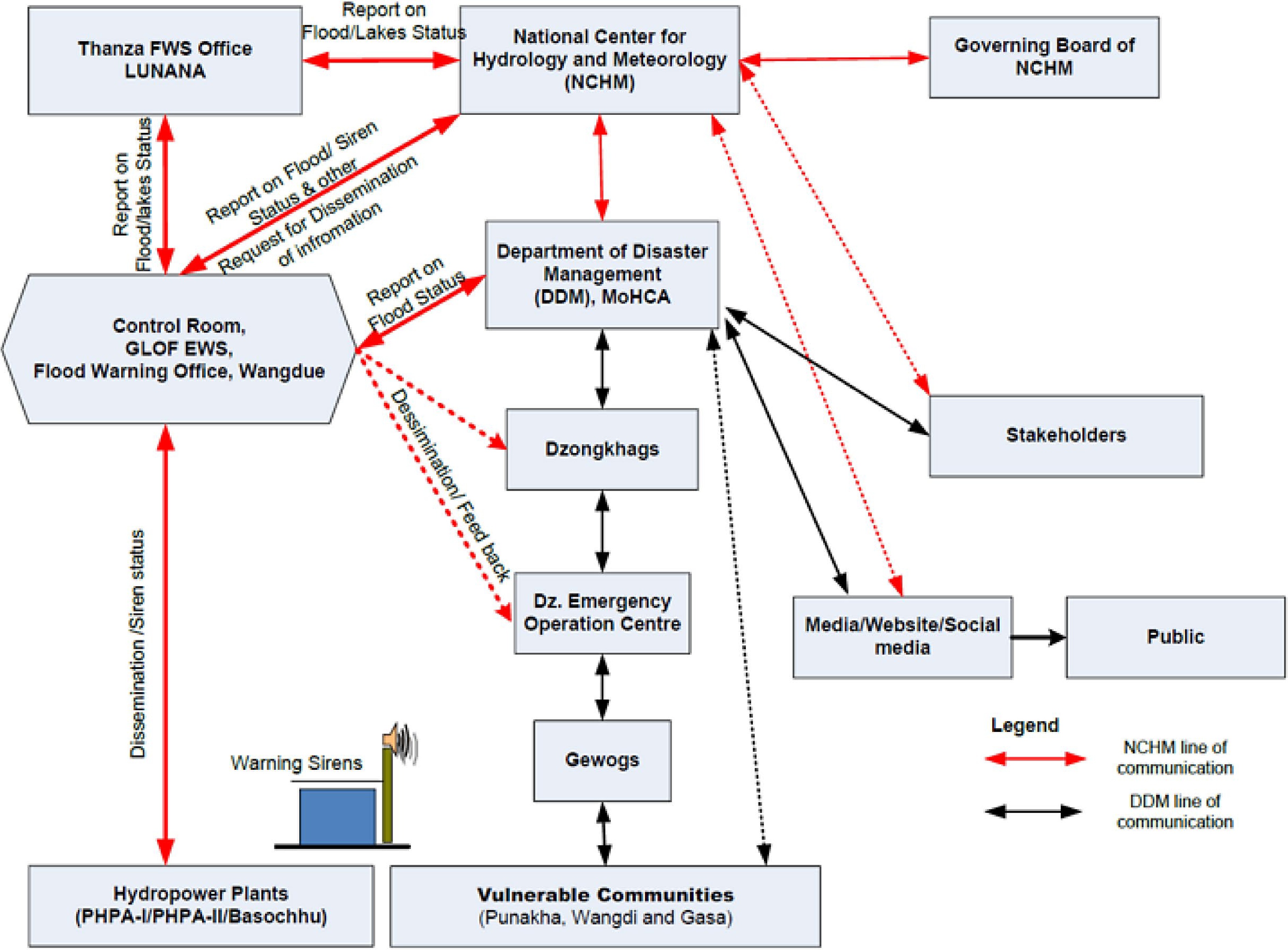
Figure 3.
Dissemination flow of GLOF warning in Bhutan[24].
Under this system, the estimated lead time (which is the time available for people to take preventive and protective actions) is between 5 and 7 h. However, this lead time is not guaranteed since the flow of flood water depends on many factors and scenarios, such as: (1) the volume of flood water released from the lakes, i.e., either full or partial breach of glacier lakes; (2) the formation of artificial dams along the river course; and (3) the amount of debris and the distance of the glacier lakes to the communities at-risk. Another limitation of the system is the incident of False Alarm that confuses the communities at-risk. Since most of the sensors in the glacial lakes are installed about 4,500 meters above sea level, these sensors are often jammed by ice. When this happens, the water level will falsely rise at Alarm Level, and triggers automatic activation of the sirens. False alarm therefore occurs under two circumstances: instrument failure due to false rise of water level or absence of personnel in the Control Room to prevent the false alarm. To avoid confusion, NCHM officials inform the residents that in the event of a false alarm, sirens can be heard only 2 to 3 times while in the real GLOF alarm, the sirens can be heard at least 12 times in a 5 min interval[20]. This approach is insufficient since the main challenge lies in the limited technical and institutional capacity of the NCHM to manage the GLOF early warning system.
Considerations for introducing QZSS-EWS
-
Lack of robustness in the EWS is one of the challenges in Bhutan. So, when part of the system (e.g., sensors) is disrupted by erratic climatic changes, there is no alternative means of sending the warning message to the communities at-risk. It should be recognized that NCHM has developed a Standard Operating Procedure (SOP) for GLOF early warning system. If QZSS-EWS will be introduced to augment the system, it is best to integrate its operations into the existing SOP. The incidents of false alarm (either due to sensor failure or absence of staff) must also be considered to tailor the QZSS-EWS functions to the conditions of the Bhutan Himalayas.
Dzud early warning in Mongolia
-
Mongolia's topography is predominantly steppe and desert. One third (approximately 1 million) of its total population are herders, who are living a nomadic life and depend on livestock for livelihoods[28]. The land area that herders occupy is characterized as semi-arid, too dry or too barren, to support vegetation. In the steppes, herders are exposed to extreme weathers (i.e., scorching heat of summer and freezing cold of winter). Under these conditions, herder communities are prone to dzud – a weather phenomenon that causes a summer to be unusually dry, followed by a winter that is unusually cold, making forage unavailable[29]. When herders are impacted by dzud, their livestock would get weak, sick, or die leading to a disaster.
Challenges in early warning that were experienced by the herders
-
The most severe dzuds in Mongolia were experienced during the winters of 1999‐2002 and 2009‐2010 that killed about 10 million and 8 million livestock, respectively[30]. These events resulted in significant damage not only to the livelihoods of herders but also to the national economy. Horses and yaks froze to death in the mountain pasture while sheep and goats died of starvation, as all grazing lands were covered by snow[31]. When these dzud events occurred, the capacity of the government for weather forecasting was limited, and early warning system for dzud was not yet fully established[32]. Shaazan[33] enumerated the challenges in dzud early warning that were experienced by the herders: (1) in most cases, herders did not receive a warning information at all, as the communication capacity of the local governments to reach the steppes was limited; (2) while some of the herders have mobile phones to receive warning information via SMS, the system was limited to 160 characters, and on top of that, there was either poor connectivity or no mobile service in the steppes; and (3) due to their nomadic lifestyles, most herders don't have televisions or radios, making it difficult for the local government to issue mass transmission of warning information. In view of these, the national government collaborated with key stakeholders to leverage capacities and resources to improve the early warning system for dzud[34].
Early warning system for dzud
-
The National Agency of Meteorology and Environmental Monitoring (NAMEM) is the lead agency responsible for dzud early warning system. The key component of the system is the Dzud Risk Map, which is developed by the Information and Research Institute of Meteorology, Hydrology and Environment (IRIMHE) of NAMEM. Using indicators, such as snow cover days, weather patterns, and agricultural vulnerability to show medium or high-risk areas, IRIMHE analyzes the climate data and use modelling software to develop Dzud Risk Maps[34]. IRIMHE issues these maps monthly by uploading it on its website, and making it accessible to decisionmakers, herders, and the general public[28]. IRIMHE also disseminates the warning information to all relevant channels when an upcoming dzud is imminent (Fig. 4).

Figure 4.
Dissemination flow of dzud warning in Mongolia[34].
While the Dzud Risk Map serves as an essential early warning tool to protect livestock and livelihoods, its effective usage requires capacity building among herders. In particular, the capacity to receive and understand qualitative and quantitative data quickly and accurately is required[28]. It is also important that IRIMHE releases the map ahead of the dzud season so that herders can have enough lead time to evacuate. Aside from collaborating with the Food and Agriculture Organization (FAO), IRIMHE also partners with Mercy Corps Mongolia in implementing the Livestock Early Warning System (LEWS) Project, which serves as a mechanism for providing drought and winter disaster warnings[32].
Considerations for introducing QZSS-EWS
-
Lack of comprehensiveness in EWS for dzud is one of the challenges in Mongolia. The Dzud Risk Map does not contain forecast or specific locations that will be impacted by dzud. Due to their nomadic lifestyles, herders have limited or no access to television, radio, or mobile phones. Hence, sending early warning information is a big challenge for the government. If the QZSS-EWS will be introduced for dzud early warning, it is useful to tailor the QZSS-EWS software with the Dzud Risk Maps that are issued by IRIMHE. This integration will be useful to the herders in confirming their position in the steppes using the Dzud Risk Map in the event they will receive warning information and act immediately by evacuating safely with their livestock.
-
Results from the three case studies point to some key observations, as discussed below.
Real need to augment early warning systems
-
In terms of location, the three cases are geographically-challenged. Communities in Bangladesh are situated in low-lying coastal plains and prone to tropical cyclone. Communities in Bhutan are situated in the Himalayas and prone to GLOF. Communities in Mongolia are situated in the steppes and prone to dzud. Moreover, these locations are not only hazard-prone, but also have limited coverage of ground-based telecommunication facilities, such as TV, radio, mobile phones internet, or Wi-Fi. All these factors pose a great challenge in the implementation of disaster early warning systems. For instance, warning information may not reach the communities at-risk or that the warning information may become unclear, distorted, or delayed due to limited ground-based communication infrastructure. Recognizing these limitations, the QZSS-EWS can specifically augment the dissemination of early warning information using satellites, which are not affected by ground-based factors such as network overloads or damage during extreme disaster events.
Entry points for QZSS-EWS operation
-
In Bangladesh, the CPP can be the entry point for the operationalization of QZSS-EWS, as CPP seems to be the most practical method of reaching the communities at risk. This means that CPP volunteers need to be oriented and trained in the functions and usage of the QZSS receiver and its overall system. In Bhutan, the QZSS-EWS may be operationalized by integrating it into the GLOF early warning system and subsequently update its SOP to include the functions of QZSS-EWS. For instance, if the water reaches the Alarm Level, staffers at the Control Room can then transmit the warning message to the QZSS Ground Station then to the satellite channel and down to the ground terminals. With the QZSS-EWS, the long chain of disseminating the warning message can be reduced. In Mongolia, the QZSS-EWS may be utilized to complement the Dzud Risk Maps, which serve as the main early warning tool to protect livestock and livelihoods. In particular, the QZSS receiver and software may be synchronized with the Dzud Risk Maps at the IRIMHE station so that herders could easily confirm their position in the steppes whenever they receive a warning message for dzud.
Community dividends
-
Generally, the QZSS-EWS operationalization also means investing in the community through orientation, training, and drills on the application of the system. Community members need to be acquainted in the QZSS-EWS system and its functions so that they can interact with the devices – that receive or channel the warning message – and subsequently act on it through evacuation. When the QZSS-EWS is operationalized, the common challenges experienced by the communities (e.g., limited access to media and delayed arrival of warning message) can be addressed. Communities may benefit from the QZSS-EWS as a tool to help save lives and livelihoods through, but not limited, to the following: (1) direct alert to individuals who are within the 'radius of disaster event' as well as notification of the nearest evacuation area; (2) automatic alarm of community sirens, public announcement of warning, or automatic opening of floodgates that are activated through the Low Power Wide Area Networks; and (3) direct display of warning message on the community electronic boards. Since warning message reaches the communities at risk in real-time by using QZSS-EWS, it allows individuals to evacuate or perform self-help activities during disaster events.
-
As shown from the case studies, there are gaps in the existing early warning systems for tropical cyclone in Bangladesh, for GLOF in Bhutan, and for dzud in Mongolia. All these early warning systems (EWS) depend on ground-based telecommunication infrastructures that have limited coverage in the low-lying coasts, Himalayas, and steppes. This limitation is often translated to a situation, where the communities at-risk could not receive the warning information. Even if the communities at-risk receive the warning information, the chances of delay or distortion are high, hindering timely evacuation.
The case studies have particularly shown that the procedures of creating and disseminating warning information are sometimes inadequate to effectively warn the communities at-risk to evacuate. On one hand, the warning information contains technical/vague terms that the communities don't understand or it contains insufficient guidance that the communities cannot act upon, as shown in the case of Bangladesh. On the other hand, the tools and equipment to disseminate warning information are insufficient or lacking redundancy as shown in the cases of Mongolia and Bhutan. These findings offer insights on what policy and practical actions can be taken to improve the early warning systems to facilitate effective evacuation. In terms of policy actions, the government needs to regularly assess the performance and upgrade the tools/equipment for early warning systems. Such policy action implies updating the SOPs and guidelines for implementing the EWS based on the lessons from past experiences as well as anticipating future challenges (e.g., climate change impact projection studies in Bhutan Himalayas). In terms of practical action, evacuation drills and other capacity building exercises using the existing EWS need to be regularly conducted at the community levels. The government can partner with local, national, and international stakeholders working in the communities to build practical capacities, such as the capacity to receive and understand warning information quickly and accurately.
Ultimately, the government needs to address the early warning challenges that hinder effective evacuation using holistic and inclusive approach without leaving the communities at-risk behind. The utilization of space satellites, such as the QZSS, is only one of the options to augment the early warning systems in remote and topologically-challenged environments. Moreover, QZSS-EWS can improve the dissemination of warning information through direct alert to individuals, direct transmission of message to outdoor electronic facilities, automatic activation of community alarms, direct display of warning message in the community electronic boards, and accurate announcement of the location of the disaster area.
Authors are grateful to the members of the Japan Team implementing the QZSS-EWS demonstration, particularly NSPS, NTT Data, and Asia Air Survey, for sharing information on the subject. The authors would like to thank the Asian Disaster Reduction Center (ADRC) for facilitating the survey among practitioners and experts from ADRC member countries. In particular, the authors are grateful for the support of the following survey respondents: Mr. Muhammad Saidur Rahman (Director, Bangladesh Disaster Preparedness Centre) of Bangladesh; Mr. Nima Tshering (District Disaster Management Officer, Department of Disaster Management) of Bhutan; and Ms. Altanchimeg Shaazan (former official from the National Emergency Management Agency) of Mongolia.
-
The authors declare that they have no conflict of interest.
- Copyright: © 2023 by the author(s). Published by Maximum Academic Press on behalf of Nanjing Tech University. This article is an open access article distributed under Creative Commons Attribution License (CC BY 4.0), visit https://creativecommons.org/licenses/by/4.0/.
-
About this article
Cite this article
Potutan G, Suzuki K. 2023. Addressing early warning challenges using satellites to improve emergency evacuation. Emergency Management Science and Technology 3:4 doi: 10.48130/EMST-2023-0004 

Addressing early warning challenges using satellites to improve emergency evacuation
- Received: 01 March 2023
- Accepted: 17 April 2023
- Published online: 27 April 2023
Abstract: Disaster early warning information, if it reaches the communities at-risk with enough lead time, allows individuals to evacuate and subsequently save their lives and livelihoods. However, in many areas of Asia, early warning information does not reach the communities at-risk. Even if it does reach them, the warning information is unclear, distorted, or delayed. This paper aims to understand the underlying factors affecting the dissemination of early warning information, and how it hinders community evacuation in the event of a disaster. It specifically looks into the tools and procedures that are adopted in early warning systems (EWS) as well as the challenges that the communities experienced in receiving the warning information. The paper presents three case studies, including the coastal communities in Bangladesh, the Himalayan communities in Bhutan, and the herder communities in Mongolia to investigate the challenges in EWS. In these communities, the ground-based telecommunication systems, internet and cellular network, have limited coverage. Additionally, the communication infrastructures in these areas are vulnerable to disruptions during extreme disaster events. Using satellites to transmit the warning information to communities at-risk will not only augment the existing ground-based EWS but will also improve evacuation procedures. While this paper builds the case for using the Quasi-Zenith Satellite System (QZSS) to enhance the effectiveness of disseminating early warning information, such effort alone is not enough. Subsequent policy and practical actions must be also undertaken to improve the early warning systems to facilitate effective evacuation.
-
Key words:
- Evacuation /
- Early warning /
- Space satellites /
- QZSS /
- EWS