


-
According to NASA's Goddard Institute for Space Studies (GISS), the average global temperature has risen by about 1.1 degrees Celsius since the 1880s. Climate change is expected to cause increase in extreme rainfall and sea levels, making record-breaking floods the new normal[1,2]. Although there are significant regional variations, the affected regions will continue to grow in number and size in the years to come. A particular manifestation of climate change is that floods are becoming more intensive and frequent with timing shifted[3,4]. A consequence is the skyrocketing of flood damage. A study by Stanford researchers reported that intensifying precipitation contributed 36 % of the financial costs of flooding in the USA over the past three decades, from 1988 to 2017. Over the next three decades, the cost of flood damage is on pace to rise 26% due to climate change alone[5]. Another recent study revealed that the risk of catastrophic mega floods in California has doubled due to global warming[6]. In Europe, the European Environment Agency reports that Europe's flood problem is about to get much worse, with annual flood losses being expected to increase fivefold by 2050 and up to 17-fold by 2080[7]. The report of Climate risk and response: Physical hazards and socioeconomic impacts[8] indicated that in many ways, Asia may face more severe impact than other regions. Bangladesh, India, and Pakistan could see extreme precipitation events more frequently than in the second half of the 20th century. In China, although climatically heterogeneous due to its location on a wide range of latitudes, risks to infrastructure and supply chains will increase due to more frequent extreme precipitation events and typhoons in many areas.
In light of mounting evidence, IPCC Sixth Assessment Report[9] pointed out some impacts of climate change as follows:
● Impacts of droughts and floods have intensified due to extreme events and underlying societal vulnerabilities;
● Climate change has intensified the global hydrological cycle, causing several societal impacts, which are felt disproportionately by vulnerable people.
Japan, due to natural and socio-economic conditions, has been battling against flood disasters for centuries and has successfully reduced flood risk and alleviated the consequence of flooding. However, climate change has been bringing floods to the general public's attention again in recent years. If air temperature rose 2 °C, the frequency of flooding would be doubled according to a report of the Ministry of Land, Infrastructure, Transport and Tourism (MLIT)[10].
Figure 1 shows the deviations of annual precipitation from the mean of precipitation in Japan from 1991 to 2020[11]. It can be seen that the deviation is plus from 2010 to 2021, indicating an uptrend. Consequently, water-related disaster damage, excluding Tsunamis, reached the highest in 2019 since the beginning of disaster statistics in Japan. Besides, although the yearly inundated area is decreasing nationwide due to various countermeasures, the economic loss per inundated area increased more than double from 1995 to 2004 according to the data released by the Ministry of Land, Infrastructure, Transport and Tourism[12].
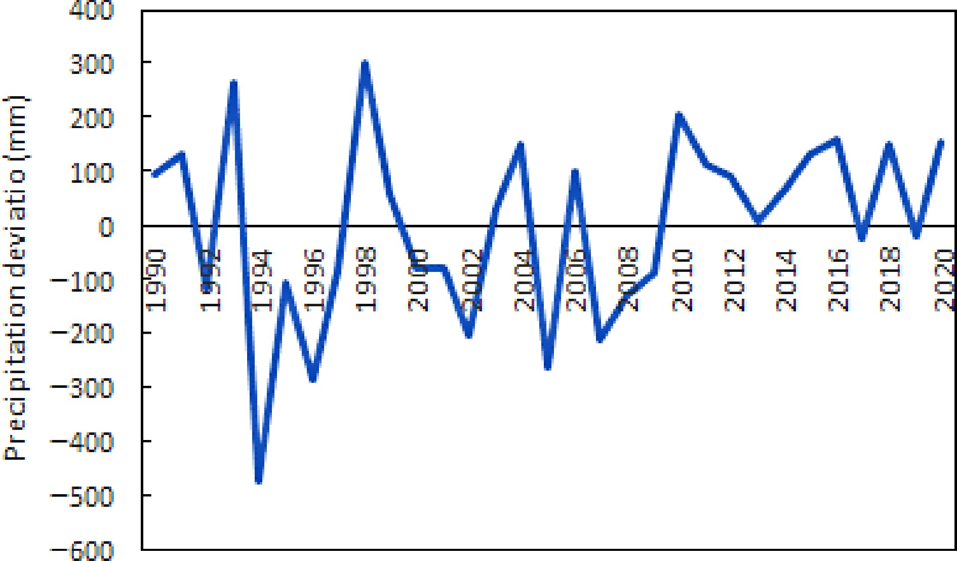
Figure 1.
Deviation of annual precipitation from the mean value of 1991−2020 (Source: Japan Meteorological Agency).
More fundamentally, Japan lags behind the USA and EU countries regarding flood control safety standards. The Netherlands has already completed flood control projects against floods that occur once every 10,000 years, and the standards in the UK and the USA are 1,000 and 500 years, respectively. In Japan, the highest standard for the most important rivers is set for flood once in 200 years. For the majority of first-class rivers, the standards are 50 to 100-year floods. For many small and medium-sized rivers, the standards are as low as 5 to 10-year floods. Even for these relatively low standards, the achievement rates are not satisfactory. For example, Arakawa River, one of Japan's most important rivers, the achievement rate of flood control projects for floods that occur once every 200 years is significantly behind at 67%.
In light of the climate-caused escalation of flooding, new strategy and countermeasures have been pursued in Japan in response to new challenges. This paper presents a snapshot of new challenges Japan is facing in times of climate change and latest advancement in flood risk management and explains the value of new government's strategies and its core component for promoting a paradigm shift. A particular focus is Japan's legal development for better flood risk governance. The national legal system of countries is essential in dealing with flood risk. In the USA, the Flood Control Act of 1936[13] established an enormous commitment by the federal government to protect people and property by authorizing civil engineering projects such as dams, levees, dikes, and other flood control measures. It was the main driver for structural countermeasures. On the other hand, the Flood Insurance Protection Act of 1973[14] mandated that lenders require flood insurance on loans secured by properties located within high-risk flood areas. The Biggert-Waters Flood Insurance Reform Act of 2012 (Biggert Waters)[15] authorized and funded the national mapping program and certain rate increases to ensure the fiscal soundness of the program by transitioning the program from subsidized rates, also known as artificially low rates, to offer full actuarial rates reflective of risk. These are laws for non-structural measures. In the European Union (EU), it has dedicated legislation, called Directive 2007/60/EC[16], on the assessment and management of flood risks. However, a research question that must be addressed is how national legislations can be further developed to encourage and promote flood risk adaptation and resilience building in times of climate change. This paper was intended to highlight the latest legal development in Japan for driving changes toward climate change adaptation and identify technical issues in implementing the legal development.
-
Risk consists of three components: hazard, exposure, and vulnerability. Climate change affects the three aspects in a compound manner. Thus, how a natural disaster risk responds to climate change can be assessed through these three components. Following this line of thinking, various data from meteorological records, population structure and government policies to past disaster damage information were collected from central government's documents, government-run statistics databases and academic publications included in Scopus and J-stage. The information was collected by keyword-oriented search and extensive reading of government's documents and academic publications. The keywords used in searching include watershed management, comprehensive flood management, flood control regulation, paradigm shift in flood management, and so on. The targeted period of time for information search is mainly the last three decades. Based on the available data and information, a narrative synthesis was performed to identify challenges in the three aspects of the risk. Then, new strategies taken by the Japanese government to deal with these challenges and the legal development to support these strategies were analyzed to elucidate its importance and roles for social transformation. Overall, the present study is a scoping review work, integrating research outcomes and policy documents to develop a thought-provoking overview of the evidence of climate change effects and actions.
-
For flood risk, the climate-related hazard is precipitation. Data from 51 sites with daily precipitation records for more than 100 years and data from about 1,300 AMeDAS locations with hourly precipitation data for 30 years have been used to detect a long-term change trend of heavy rainfall nationwide. According to the Japan Meteorological Agency, the number of days with daily precipitation of 100 mm or more and 200 mm or more tends to increase significantly over 106 years. Comparing the period of 1977~2006 with the period of 1901~1930, the days with 100 mm or more rainfall and days with 200 mm or more rainfall are about 1.2 and 1.4 times, respectively[6]. Climate change is enhancing the flood hazard. A consequence is the percentage of state-managed rivers having their water levels exceeding flood danger levels during a year increasing, as shown in Fig. 2[17].
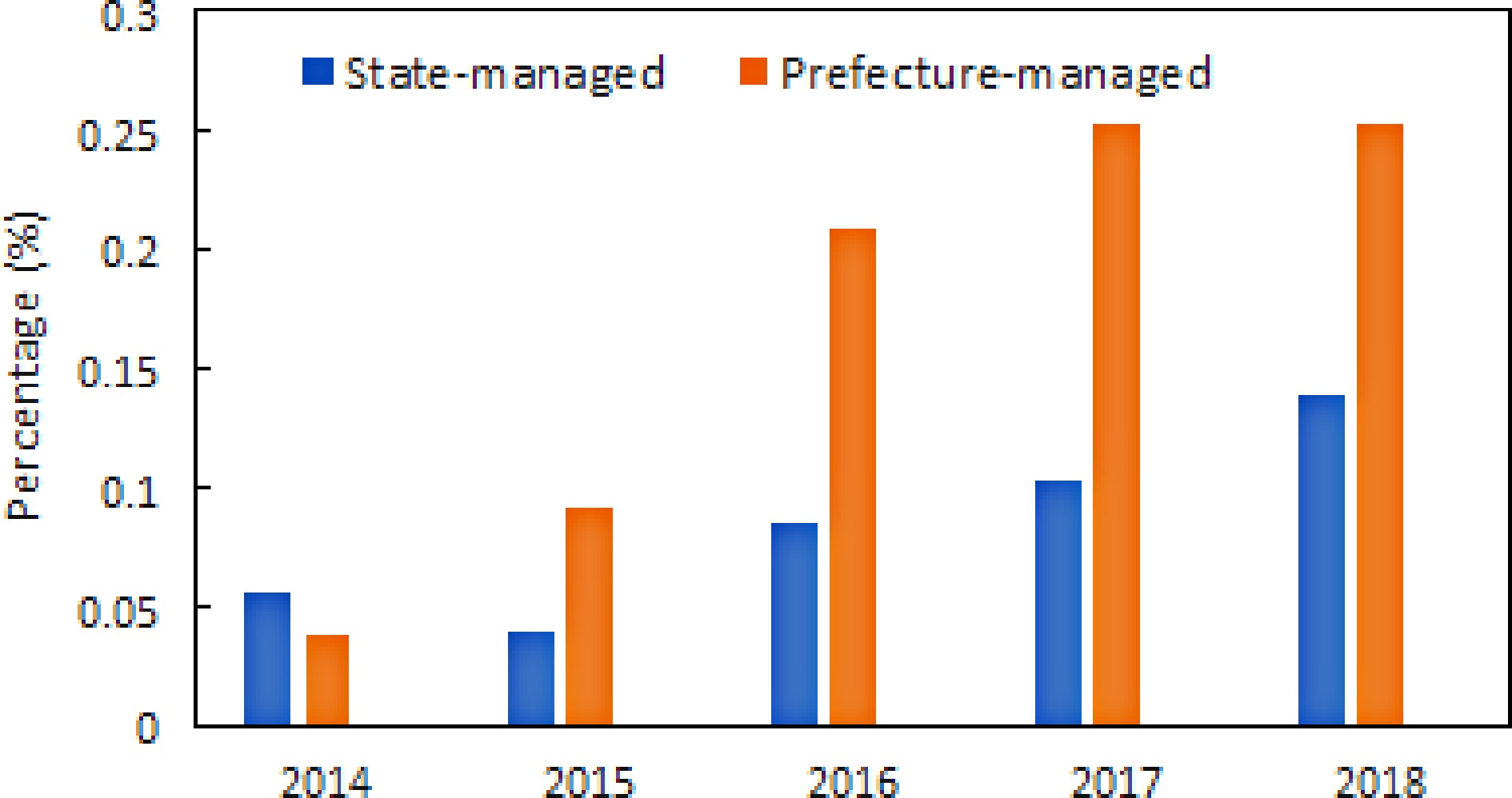
Figure 2.
Change in percentage of state-managed rivers having water levels higher than flood danger water levels (Source: MLIT).
The data also shows that small and medium-sized rivers managed by prefectures are being more affected than state-managed rivers by climate change.
Small and medium-sized rivers in Japan generally have a small basin area, a short river channel length, a single cross-section, and a steep riverbed. Because of these attributes, the flow in small and medium-sized rivers is fast, and the water level rises rapidly. Climate change will shorten the runoff time, and water levels will increase more rapidly. Therefore, how to upgrade the safety level for small and medium-sized rivers is a critical issue Japan must solve. As a matter of fact, the total length of rivers managed by prefectural governments is about 113,000 km, much longer than 10,600 km for nationally managed rivers.
Vulnerability
-
In addition to climate change-caused intensification of hazard, Japan is becoming increasingly vulnerable to flood disasters for the reasons given below.
Population aging
-
Figure 3 shows changes in the percentage of people aged 65 and above in Japan. Data after 2020 are a projection. It can be seen from the figure that Japan is experiencing severe aging. Studies in geriatrics have revealed that the balance power of a person in their 60s and 70s is 30% and 20% of that in their 20s, respectively[18]. Impairment in balance performance can hinder the evacuation of the elderly since falling is a factor when evacuating older people.
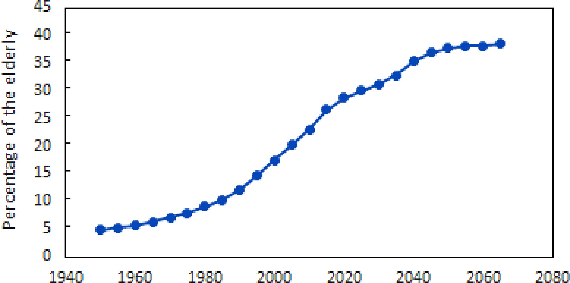
Figure 3.
Change in percentage of people above 65 in Japan.
Figure 4 shows the number of male and female victims in different age groups in the Kuma River flooding disaster that occurred in 2020. As one can see from the figure, there were no young victims, and the death tolls increased with age. Besides, among all victims, males and females accounted for 46% and 54%, respectively.
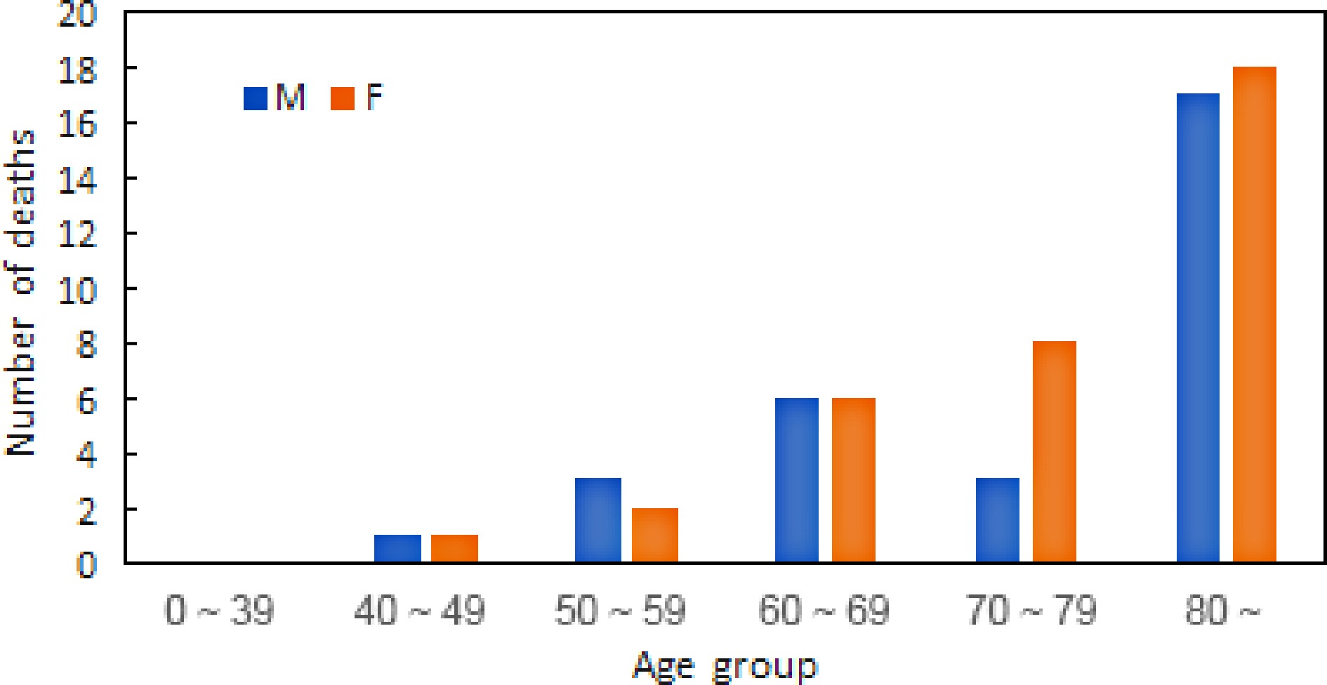
Figure 4.
Death toll in different age groups in the Kuma River flooding (Data source: e-Stat, Japan).
Weakening of community's coping capacity
-
In Japan, a nationwide organization for flood control activities is named Suibodan (flood control group). Flood control group members are mainly composed of residents who have regular careers on ordinary days. But when there is a risk of flooding in the area where they live, they perform flood control and rescue duties. Therefore, it can be described as a community-based flood management system. As shown in Fig. 5, the number of flood control personnel have declined.
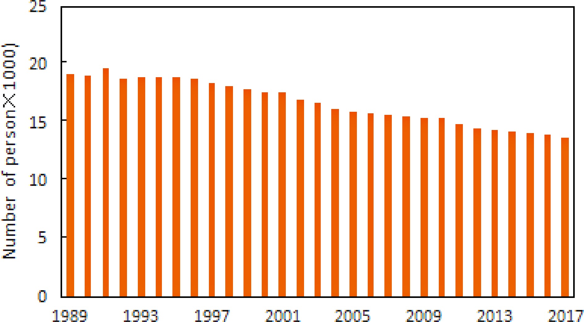
Figure 5.
Decline in the number of flood control personnel (Source: MLIT).
Furthermore, they are also aging. Figure 6 shows the age distribution of flood control group members, and members above 60 years old account for 44%. The decrease in the number and strength of flood control personnel will weaken the community's coping capacity and increase flood vulnerability.
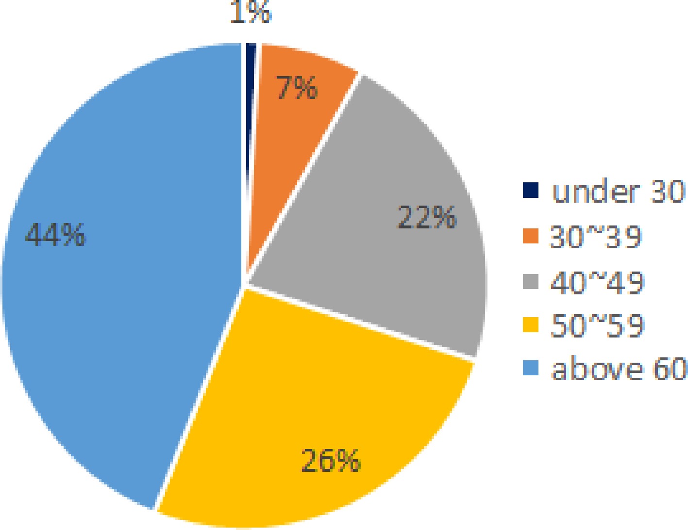
Figure 6.
Age distribution of flood control personnel (Source: MLIT).
Facility aging and population shrinking
-
In addition to riverbanks, there are many other flood management facilities in river channels, including sluice gates, weirs, pumps, etc. In state-run river reaches, there are about 10,000 facilities, and the facilities that have been installed for 40 years account for about 40% of the total at present, and the proportion will reach 60% in 10 years and 80% in 20 years. Meanwhile, the population of Japan has been declining consistently since 2015, and the rate of decline has been accelerating with each passing year. In 2029, it will fall below 120 million. The population is predicted to decrease by nearly 10 million people every decade. The population decrease, especially in rural areas, will lead to a significant revenue decrease, unable to support the repair, re-building, and maintenance of aging facilities. Contrary to the national trend, the population in Tokyo has been increasing steadily due to population influx from rural areas. As a result, the capacity of evacuation shelters in Tokyo needs to be improved. Tokyo is developing a long-distance evacuation plan. It is an innovative initiative, and how to optimize evacuation routes is a technical question that needs to be addressed.
Land ownership
-
One of Japan's difficulties in river management is that the nation does not own all floodplains. As shown in Fig. 7, a considerable part of the floodplains along Japan's first-class rivers are private, and farmland and orchards existed on some privately owned floodplains before the birth of the Japan River Law. Due to such a historical reason, River Law allows the continuation of farming on floodplains if the frequency of flooding is low. Nevertheless, large plants on floodplains may reduce channel conveyance. With climate change, the frequency and magnitude of flooding on these agricultural floodplains may increase, and the presence of agriculture on floodplains may cause additional risk for nearby residential areas. The balance between individual rights and public safety needs to be studied for better management of rivers in Japan in the era of climate change.
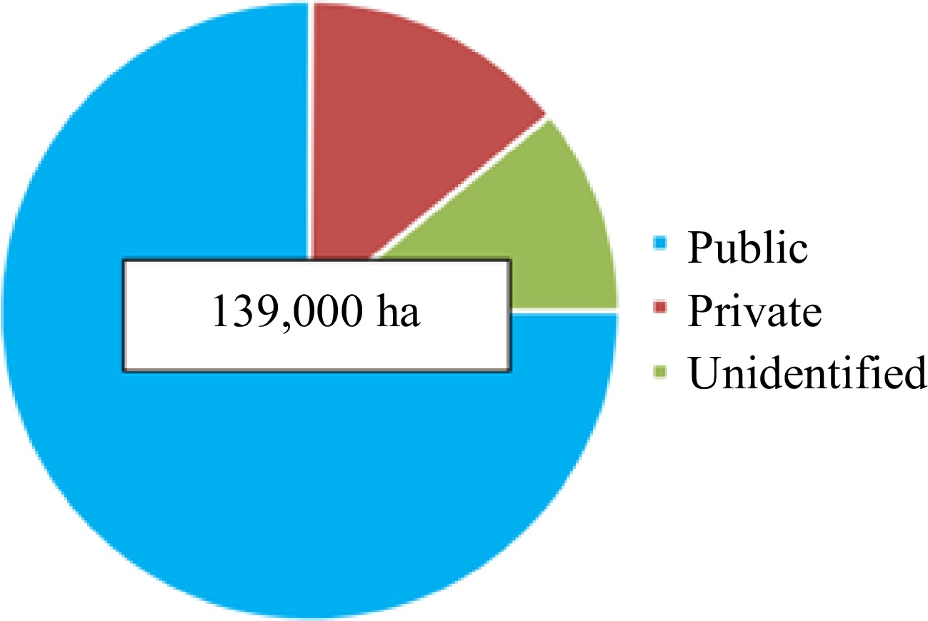
Figure 7.
Ownership of first-class river floodplains (Source: MLIT).
Exposure
-
Typhoons occur in Japan almost every year. Figure 8 shows the number of typhoons that made landfall from 1960 to 2019[11]. Dividing the data into two 30-year periods, 1960−1989 and 1990−2019, the number of Typhoons landed in the two periods is 81 and 97, respectively. In 2010, Typhoon No. 4 hit Hokkaido for the first time. In 2016, Typhoon No. 10 made landfall on the Pacific side of the Tohoku region for the first time in history and caused significant damage in Hokkaido. It lasted 14 d and 3 h after its birth, breaking the record for the longest-lived Typhoon generated near Japan. In 2017, Typhoon No. 5 landed on the Kii Peninsula and caused heavy rains nationwide. It lasted 18 d and 18 h, making it the third longest-lived Typhoon in the Typhoon's observation history[11]. Figure 9 shows the number of flood-caused death and injured during the last decade. With more typhoons landing and the path extending northernly, people's exposure to danger increases significantly. To deal with the increase in flood risk due to climate change, new pathways toward safety must be explored.
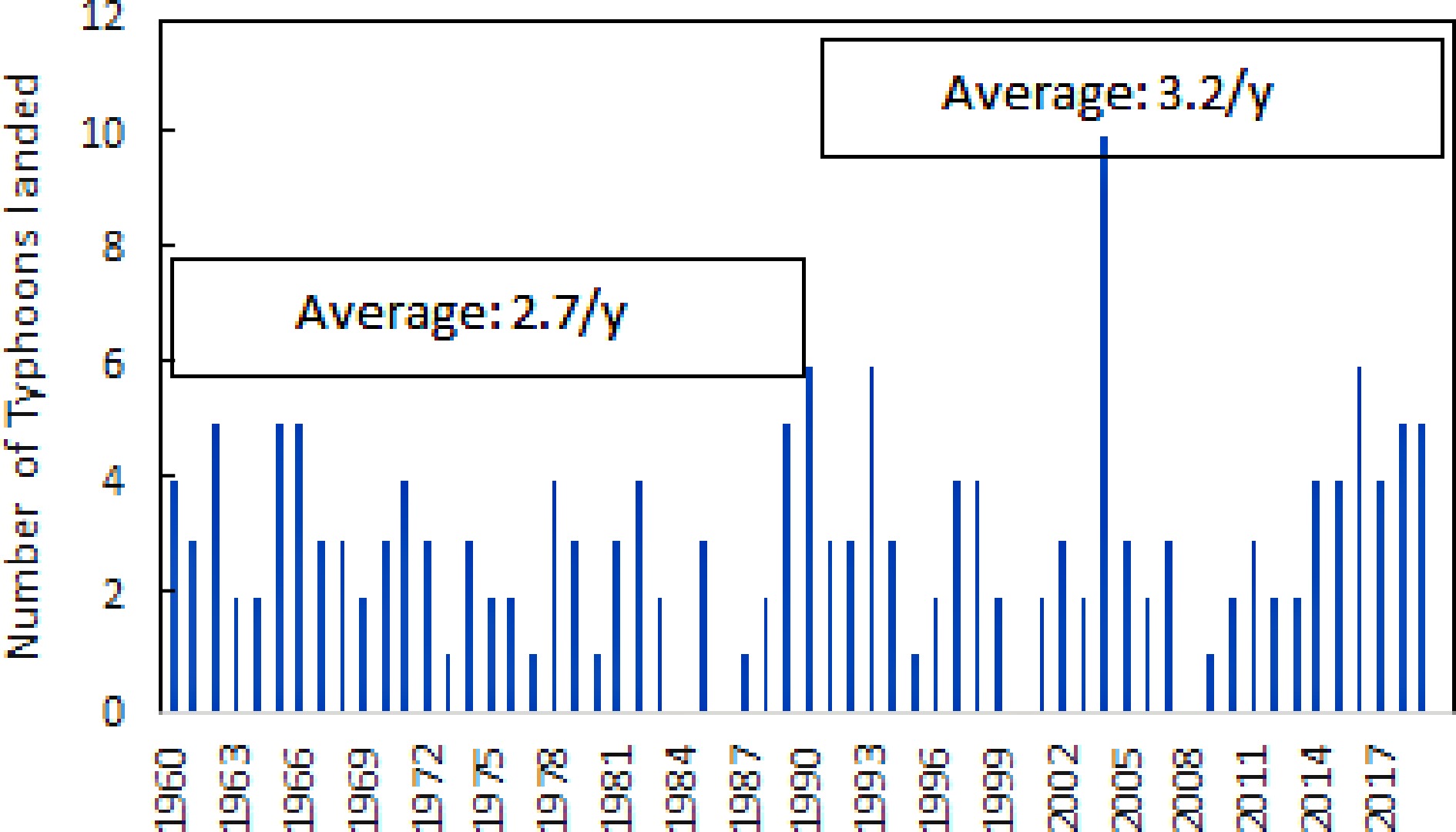
Figure 8.
Number of typhoons landed from 1960 to 2019 (Source: Japan Meteorological Agency).

Figure 9.
Number of flood-caused death and injured from 2000 to 2019 (Source: MLIT).
-
After World War II, Japan's flood control mainly relied on reservoirs and dikes. The society believed that building river embankments that would never breach was possible. Therefore, this approach can be described as channel-focused flood control. But over the years, flooding caused by levee breaching or overflow proves this is a safety myth.
Using data from 1942 to 2007, Huang[19] revealed three shift points in the number of flooding victims in Japan. From 1942 to 1959, the flood fatality shifted significantly upward, then decreased largely after 1960. Another downward turning point occurred in 1984. In 1961, the Soil Conservation and Flood Control Urgent Measures Act and Flood Control Special Account Act were enacted, and Japan's first long-term flood control programs were developed accordingly. By 1984, 60% of the planned river improvement works for flood control were completed along the major Japanese rivers. The two downward turning points can be attributed to the legal system development and subsequent implementation of flood control measures. On the other hand, there was no downward turning point in Japan's flood-caused economic loss from 1942−2007.
In 2015, Japan's Ministry of Land, Infrastructure, Transport, and Tourism released a Vision for Rebuilding a Flood-Conscious Society[20]. It was a milestone in Japan's water governance. The underline concept is the paradigm shift from river water control to river basin water management. The river water control is to contain all flood waters in the river channels to prevent disasters from happening, and it is an administration-led countermeasure. By contrast, river basin water management is to achieve disaster reduction through comprehensive measures, including land use planning, building construction regulation, emergency response system establishment, etc. It is a joint effort of administration, business, community, and residents. One specific approach for regulating land use and building construction is to enact development and building construction permitting systems.
Despite the shift in management concept, flood damages in Japan continue to rise. In 2019 and 2020, nine river basins in Japan were flooded. In particular, the flood disaster consequence was severe in 2019. There were 122 deaths from flooding, 371 injuries, and four missing persons; flooded residential areas and agricultural lands amounted to 21,952 ha and 58,898 ha, respectively. Three thousand three hundred seventy-nine houses collapsed, and 27,792 homes flooded. The general property damage and the public facility damage reached 1,615,007 million yen and 534,246 million yen, respectively. Figure 10 shows the distribution of economic loss by region. The total amount of damage was 2.15 trillion yen, the highest since Japan's flood disaster statistics began[21].
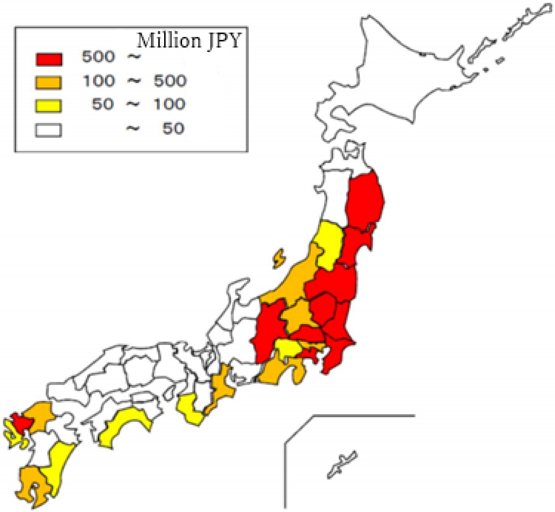
Figure 10.
Flood-caused economic loss by region in 2019 (Source: MLIT).
In 2020, between July 3 and 31, 2020, levee breaches occurred in seven river basins administered by the state and 58 river basins managed by prefectures. The total flooded area is 13,000 ha. The number of dead and missing persons reached 86, and 16,600 houses were damaged. The main affected area was Kumamoto Prefecture.
As water-related disasters have become more severe and frequent due to climate change, and resultant flood damage far exceeded what was projected before, the Japanese government issued its latest river basin management plan on March 30, 2021[22]. One of the main features of the plan is to implement integrated and comprehensive management of the entire river basin based on the coordination of all stakeholders, taking into account the relationship between the upper, middle, and lower reaches of the river, the relationship between the mainstream and tributaries, the infiltration, and the land use regulations. Another feature is the organic combination of structural and non-structural means. The plan has been applied to 109 first-class and 12 second-class watersheds in Japan.
-
To support such an integrated river basin management, the Act on Countermeasures against Flood Damage of Specified Rivers Running Across Cities was amended in 2021. The latest revision of the law can be considered a breakthrough in water governance because of the following seven aspects:
(1) The scope of the application of the act is expanded to the whole of Japan so that small-scale development in urbanized flood-prone areas also needs to obtain the permission of relevant authorities from the perspective of disaster prevention, which effectively compensates for the insufficiency of urban planning in consideration of flood risk.
(2) A coordination meeting system is required for water management to strengthen communication between the central government, local governments, and the public, which can promote the formulation and effective implementation of river basin countermeasures.
(3) The establishment of flood retarding zones along rivers are required to ensure the flood-carrying capacity of rivers. It is the same as the European concept of 'Room for River'[23], and also coincides with the 'Geti' design idea used in ancient China for the management of the Yellow River.[24]
(4) Strengthen the protection of urban green spaces with rainwater storage and infiltration functions. It is similar to the concept of sponge city construction promoted in China[25].
(5) Establish a system to confirm the risk of flooding for residential buildings. This system allows the government to make appropriate administrative permits.
(6) Delineate flood damage prevention areas and urge residents in dangerous areas to relocate. It can reduce the possibility of damage to the life, health, and property of residents in high-risk areas.
(7) The Minister of Land, Infrastructure, Transport, and Tourism has expanded the scope of authority in the event of a disaster, which can facilitate rapid disaster recovery.
A centerpiece of the amendment is the establishment of a 'flood damage prevention zone' system. The prefectural governor is given the authority to designate an area as a flood damage prevention zone if that land is at risk of significant harm to the lives and properties of residents due to flooding. In the designated land area, for the construction of residential houses and facilities used by persons requiring special care, it is necessary to confirm by prior permission whether the floor surface of the room is higher than the water level related to the expected inundation depth and whether essential safety measures have been taken to prevent the building from collapsing by flooding, etc. At the same time, even for projects already entered into the construction stage, it should also be confirmed by the prior permission system whether necessary measures have been taken for safety against floods for development activities such as the construction of facilities for elderly persons.
For example, a business operator engaged in development activities such as embankment must submit the development area's location, scale, and construction plan to the prefectural governor. Prefectural governors who receive applications confirm whether they meet the technical standards of the Ministry of Land, Infrastructure, Transport, and Tourism for items such as whether ground erosion would occur in the event of flooding to ensure safety.
For building development, no matter if it is a residential house on private land or a public facility construction, water-resistant architecture designs such as Piloti, high foundations, or using a water shuttle are now needed to meet the requirement of a specified water depth as sketched in Fig. 11. Through such a permission regulation, the development that does not meet safety standards will be prohibited. A technical issue in the permission system is the way to determine the specified water depth for these structures. In theory, it should be estimated according to a given return period of flooding. However, the setting for the target flood or safety level has not been sufficiently discussed. A straightforward approach is to assign a depth corresponding to a design rainfall with a certain return period such as 200 years. It could also assign the depth corresponding to Probable Maximum Precipitation (PMP) at the site as the safety requirement. PMP has traditionally been considered a static value. However, the static nature of the PMP has been questioned due to increased moisture availability and precipitation efficiency resulting from climate change[26]. Model simulations showed that PMP could be driven by projected future climate[27]. Furthermore, methods are being developed to incorporate climate-change-induced non-stationarity into PMP estimates such as the 'hybrid' approach combining conventional methods for PMP and Earth system model (ESM) data[28]. Considering the uncertainties in estimating PMP in the context of climate change, a safety margin is proposed below.
$ \begin{split}\rm Safety\; Margin = \;&\rm\{Depth\; P\; (corresponding \;to\; PMP) - Depth\; D\; \\&\rm(corresponding\; to\; a\; design\; rainfall)\} / Depth\; D \end{split}$ 
Figure 11.
Water resistant architecture in flood damage prevention zones.
The logic is that the depth corresponding to a design rainfall provides a reasonable level of safety, somewhat similar to the break-even point used in business sector. Therefore, the specified water depth can be set as
$\rm Specified\; Depth = Depth\; D +Safety\; Magin \times Depth\; P$ (1) Additionally, to ensure the structure is safe against flooding, it requires calculating the horizontal force of flow acting on structures based on projected flow velocity and water depth of the potential flooding.
It must be emphasized that the purpose of establishing flood damage prevention zones is not to eliminate any flooding. On the contrary, it is to minimize the damage on the premise of flooding. Worded differently, it is an area where flooding is expected to occur frequently even if flood control measures such as embankment, infiltration, and retarding are all implemented. Instead of preventing inundation, damage reduction is the management objective in flood damage prevention zones. It is the most crucial point in the paradigm shift, which is to live with water.
Following the amendment of the Act on Countermeasures against Flood Damage of Specified Rivers Running Across Cities, Yamato River was chosen as a pioneering site for watershed-oriented flood management. Yamato River is a Class A river in the Kansai region of Japan and flows through the Nara Prefecture and Osaka Prefecture to the Osaka Bay. Rivers in Japan are classified into Class A and B. Class A rivers are waterways important to the economy and nature conservation of the nation and managed by the central government. The smaller, but also important rivers are designated as Class B rivers and managed by the local governments at the prefecture level.
Two towns within the watershed, Kawanishicho, and Tawarahonchou were targeted for being designated as flooding prevention zone[29]. Figure 12 shows the potential inundation depths corresponding to a design rainfall (return period = 100) and PMP.
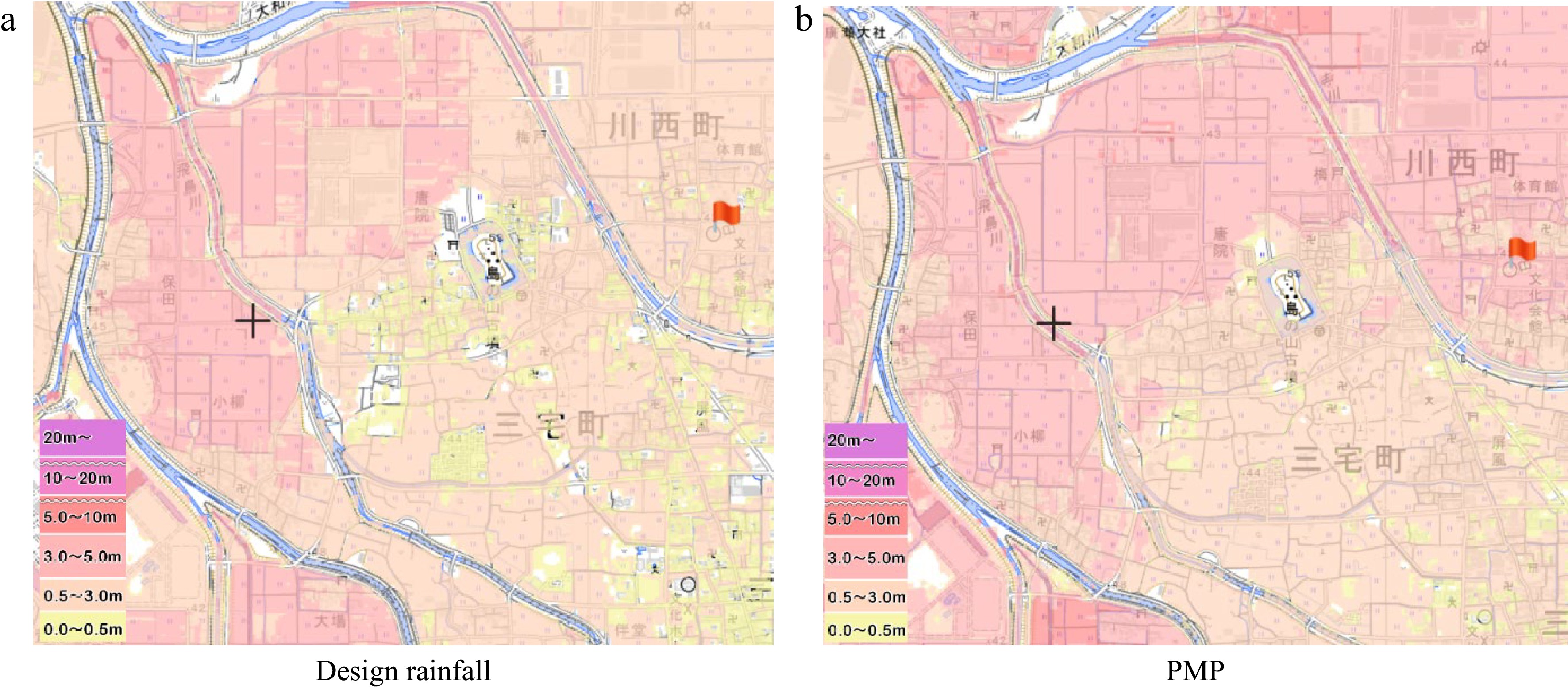
Figure 12.
Flood hazard map for Kawanishicho corresponding to two types of rainfall (Source: MLIT).
The inundation depths in the residential areas of the town corresponding to the design rainfall and PMP are about 0.5 m and 0.5~3.0 m, respectively. If the specified depth for buildings is set according to (1), it will be 2.9 m. This implies that for most houses they should be remodeled to have the first floor used as garage. Once it is done, the existing parking spaces in the residential areas can be turned to be pervious surfaces to increase infiltration. Therefore, transformation from ordinary houses to flood-resistant houses can reduce house-inundation risk, restore local infiltration capacity and generate new building construction business. To promote such a residential building transformation, legal development is needed to establish government subsidy programs to support the change.
To realize the mission of flood damage prevention zones, another critical measure is to have an adequate warning and evacuation system for flood damage prevention zones since it allows flooding.
Japan's flood warning system consists of five levels. Level 1 is an early warning the Meteorological Agency of Japan will issue for the possibility of heavy rain. The Meteorological Agency also issues Level 2 warnings for heavy rain and flooding alerts. Level 3 indicates that danger is approaching, and municipalities will issue the warning. At this stage, the elderly and disabled should start evacuation while others prepare for evacuation. Level 4 indicates the need for a complete evacuation. Level 5 signifies the occurrence of disaster and the need to take whatever action is necessary to safeguard one's life. In implementing this system, a technical question is how to determine each level. Currently, the number of rivers with such a multi-level warning system account for just less than 2% of all important rivers in Japan[30]. In the case of Yamato River, the two candidates for flood damage prevention zones are in the tributary basins of Yamato River, where the full-scale warning system has not been established although water level information is provided. Therefore, there is an urgent need to develop full-scale flood warning systems for small and medium-scale rivers in parallel with the designation of flood damage prevention zones.
-
Climate change is exacerbating flood disasters in Japan. Conventional approaches must be improved to respond to the threats. The climate challenge in Japan is so severe because it coincides with the ageing of the population and infrastructure. With climate change, it is extremely difficult, if not impossible to prevent flooding. Therefore, a new strategy is to minimize the damage or the consequence of flooding. The vision for rebuilding a flood-conscious society and subsequent legal development to support the realization of the vision can be considered a scientifically sound response to climate change although more research development for design details is indispensable and its effectiveness is to be assessed in years to come.
-
This paper provides a compact overview of the challenges Japan faces regarding flood risk in the era of climate change and the latest initiatives to meet the challenges. It is not intended to be complete but selective for highlighting certain vital aspects. It analyzed the recent legal system development, focusing on a new approach, 'flood damage prevention zone', and its value. The main points coming from this overview analysis are summarized below.
(1) Climate change, population and facility aging are intertwined to cause increase in flood risk in Japan.
(2) The latest legal system development for flood risk reduction can be characterized as a paradigm shift from river channel-focused control to watershed-oriented management.
(3) For water-resistant architecture design in the flood damage prevention zone, a proposal was made for setting up a safety level in the context of climate change. If adopted, it can reduce house-inundation risk, restore local infiltration capacity and generate new building construction business.
(4) It pointed out that the success of the paradigm shift will depend to a large extent on the further development of flood emergency response systems, especially for small and medium-sized watersheds. The current level of flood emergency response systems in small and medium-sized watersheds does not match the need for emergency management in managing flood damage prevention zones.
Such information sharing is useful in promoting better flood risk management in response to climate change across the world.
-
The authors confirm their contribution to the paper as follows: study conception and design: Fan J, Huang G; data collection: Fan J, Huang G; analysis and interpretation of results: Fan J, Huang G; draft manuscript preparation: Fan J. Both of authors reviewed the results and approved the final version of the manuscript.
-
The data that support the findings of this study are available in Portal Site of Official Statistics of Japan (
www.e-stat.go.jp ). These data were derived from the following resources available in the public domain: Japan Meteorological Agency (www.jma.go.jp ). -
The authors declare that they have no conflict of interest.
- Copyright: © 2023 by the author(s). Published by Maximum Academic Press on behalf of Nanjing Tech University. This article is an open access article distributed under Creative Commons Attribution License (CC BY 4.0), visit https://creativecommons.org/licenses/by/4.0/.
-
About this article
Cite this article
Fan J, Huang G. 2023. Flood risk management in Japan in response to climate change: shift from river channel-focused control to watershed-oriented management. Emergency Management Science and Technology 3:23 doi: 10.48130/EMST-2023-0023 

Flood risk management in Japan in response to climate change: shift from river channel-focused control to watershed-oriented management
- Received: 18 June 2023
- Accepted: 04 December 2023
- Published online: 29 December 2023
Abstract: Flood risk increase due to climate change is one of the world's most pressing issues. Different countries and regions may take or have taken different approaches to deal with it. Therefore, information sharing and learning from each other are essential for achieving flood risk reduction on a global scale, especially in times of climate change. This paper provides a diagnosis of challenges in flood risk management in Japan in response to climate change. It highlights change in hazard and exposure and increase in vulnerability. Further, it placed its attention on new strategies taken by the Japanese government to counteract climate change impacts with a particular focus on the latest legal development to better support flood risk management. Although there are large amounts of research concerning climate action in the existing literature, the majority of them focus on technical and social aspects. The present study enriches literature on flood risk management and sheds new light on how to advance integrated river basin management.
-
Key words:
- Climate change /
- Flood risk /
- Paradigm shift