












-
It is an important issue to reduce traffic accidents and enhance road safety. Therefore, it is essential to reconstruct these accidents in order to determine the responsibility, find out the causes, and establish efficient preventive measures. On-site data include direct physical evidence like the damage of the colliding vehicles, the stopping positions of the involved vehicles, the injuries of the accident victims, and other traces such as tire marks and the distribution of debris. The off-site data comprise the results of expert evaluations, road surveillance videos, the global positioning system (GPS) track of the vehicles, the operating data of event data recorders (EDRs) and the vehicles' operation information from the cloud, etc.[1].
Despite these achievements, modern traffic accident reconstruction still faces several critical challenges. (1) Multisource data from EDR, GPS, and video recordings have obvious heterogeneity in their timestamps, coordinate systems, and sampling frequencies, leading to difficulties in effective alignment and fusion. (2) Traditional reconstruction methods lack a unified framework to deal with data conflicts, missing sources, or information redundancy. (3) The simulation modeling process relies too much on experience and lacks data-driven closed-loop optimization mechanisms. Therefore, it is urgent to carry out in-depth research on multisource data alignment and fusion methods to improve the accuracy, robustness, and engineering practicability of accident reconstruction.
In short, the data sources for modern traffic accident reconstruction are becoming increasingly diversified and heterogeneous, and the accurate alignment of multisource heterogeneous data has become a core technical challenge restricting the further improvement of the accuracy of accident reconstruction. The computer simulation-based multisource data alignment method proposed in this paper is designed to fully and effectively utilize the complementary advantages of EDR, GPS, and video data; flexibly cope with various data failure and information redundancy scenarios in actual accident reconstruction work; and provide reliable technical support and realistic test scenarios for the safety testing and performance evaluation of intelligent vehicles.
Based on the point above, this study makes the following novel and targeted contributions.
(1) A unified spatio-temporal alignment framework for EDR, GPS, and on-site video data is constructed to systematically solve the problems of time drift, spatial mismatch, and information asynchrony among heterogeneous data sources.
(2) A weighted fusion and conflict resolution strategy is proposed to ensure reliable fusion even when individual data sources are missing, disturbed, or inconsistent.
(3) A multisource data-driven closed-loop simulation optimization method is established, which significantly improves the accuracy, authenticity, and reproducibility of traffic accident reconstruction.
-
The collision index of the traffic accident depth investigation database is primarily dependent on on-site trace physical evidence and vehicle deformation information, and the difficulty of carrying out accurate accident reconstruction is notably increased when the actual form of the accident deviates from the ideal theoretical state[2]. With the growing popularity of EDRs installed on motor vehicles and the opening of data reading interfaces for certain vehicle models, EDRs can collect a wealth of sensing information and key dynamic data such as seat belt usage status, real-time vehicle speed, brake deceleration, and degree of gas pedal opening in the critical moments before and after a collision, which can effectively make up for the lack of detailed dynamic information in traditional accident reconstruction software packages. However, in determining the responsibility in accidente related to red light runningand other intersection collisions, EDR data are difficult to time-synchronized with the intersection's traffic signal control system, resulting in the limited evaluability of a single EDR's data in such scenarios; the combination of EDR data with time data from a global navigation satellite system (GNSS) or the camera-recorded traffic signal's light status and related technical analysis can significantly enhance the overall assessment level of accident liability and the process of how the accident occurred[3−5].
Video footage from on-site and road surveillance is also an indispensable key data source for accident reconstruction. For example, Gao et al. used the scratch accident analysis method to accurately determine the key dynamic parameters of bus and e-bike collision accidents[6]. Academic research in the field has consistently emphasized that accident reconstruction work should be carried out on the basis of integrating multisource information and cross-verification. Qiu Feng pointed out that the collision speed of the involved vehicles can be obtained from multiple technical approaches, and this needs to be comprehensively verified and compared from different perspectives; they also argued that the organic combination of EDR data, video surveillance information, and professional software simulation-based reconstruction can effectively overcome the inherent limitations of a single reconstruction method[7].
In terms of collision scene-related data collection and modeling, traditional manual measurement and mapping are highly prone to human errors and low efficiency because of the complexity of accident scenes and the vulnerability of physical evidence. Kamnik et al. innovatively used terrestrial laser scanners and drone-based aerial survey technology for high-precision three-dimensional (3D) measurement and modeling of accident scenes to improve the overall efficiency and data accuracy of scene collection[8]. Jin et al. combined traditional manual on-site measurements with drone-based data acquisition methods and used professional simulation software to reconstruct a detailed 3D model of the accident scene[9]. Liu Jun et al. also used drone tilt photogrammetry technology to achieve efficient and comprehensive on-site surveys of traffic accident scenes and realize digitized on-site 3D reconstruction with high geometric precision[10].
Among the technical means of traffic accident reconstruction, computer simulation technology plays a crucial role in restoring accident processes and verifying the dynamic parameters, with commonly used professional simulation software including PC-Crash, MADYMO, and Ansys LS-Dyna. Kolla et al. relied on computer simulation technology to accurately reconstruct the complete vehicle motion state during accidents and verified the rationality of the relevant dynamic parameters[11], and Zhou et al., using the unscented transformation, proposed a scientific parameter analysis method for accident reconstruction and verified its validity and accuracy through multiple simulation experiments[12]. Finite element simulation technology can conduct in-depth and accurate quantitative analyses of collision-related vehicle deformation and the mechanisms of human body injury in accidents. Baker et al. explored the quantitative effect of uncertain parameters in reconstructed pedestrian collisions on the accuracy of predicted injuries[13]. Gu analyzed several typical vehicle collision accidents and constructed a practical vehicle damage prediction model based on finite element analysis[14]. Liu et al. developed an intelligent reconstruction method for traffic accidents driven by multisource data[15], and Wang et al. used a combination of professional geomatic mapping technology and numerical simulation to validate the feasibility of their proposed accident reconstruction method[16].
Joint simulation reconstruction techniques integrating multiple software and technical methods can further optimize the performance and accuracy of accident reconstruction models. Cheng et al. established a joint simulation model using PC-Crash and MADYMO to verify the accuracy of traffic accident reconstruction results[17], and Santos et al. synthesized multiple reconstruction methods and applied the integrated method to motorcycle and car collision accidents and verify the relevance and effectiveness of the method[18]. For traffic accidents involving self-driving vehicles and advanced driver assistance system (ADAS)-equipped vehicles, Kim et al. focused on the automatic emergency braking (AEB) system to establish a targeted simulation environment for analyzing the causes of accidents[19], and Buck et al. used morphometric 3D reconstruction technology to effectively solve the technical problem of reconstructing of complex vehicle crushing accidents[20].
Existing accident reconstruction approaches generally fall into two categories: Theoretical deduction and numerical simulation. Theoretical methods are based on kinematics and conservation laws, but they are difficult to adapt to complex collision scenes. Simulation methods (PC-Crash, MADYMO, CARLA, etc.) can restore accident processes visually, but most rely on manual parameter adjustment and lack automatic multisource data fusion mechanisms.
Research on data sources for accident reconstruction
-
Early reconstruction mainly used on-site physical evidence, which is inefficient and subjective. With the development of intelligent vehicles, EDR, GPS, and video data have gradually been applied. However, most studies only use a single data source or simple combination, and cannot solve the problems of spatio-temporal heterogeneity and information conflict among multisource data.
Limitations of existing research
-
(1) Lack of a unified spatio-temporal alignment framework for heterogeneous data;
(2) Insufficient research on adaptive fusion and conflict resolution of multisource data;
(3) The simulation modeling process is not standardized and lacks complete reproducible details;
(4) The robustness and generalizability in the case of missing data are insufficient.
Data acquisition and preprocessing
-
The multisource data analyzed in this work come from a real-world vehicle crash on a mountainous highway in 2023. It includes a complete set of EDR logs, GPS trajectory records, and surveillance video footage covering the entire incident.
Acquisition and purification of EDR data
-
Vehicle-mounted accident recorders provide EDR data at a rate of 10 Hz. The important parameters consist of time, speed, the state of the brake pedal, the master cylinder's pressure, the steering angle, gear position, the distance to lane lines, and driving mode. An EDR is an effective onboard instrument for saving and recording the vehicle's motion, such as the current speed, longitudinal and lateral acceleration, and other working features. After several steps, the data are processed by professional devices with experts to ensure the accuracy and reliability of the original data. Because of the complicated and changing situations of the vehicles, for instance, large vibrations, electromagnetic interference, and unexpected power variations, as well as some systematic errors in the EDR instruments, the collected basic data may have inconsistent forms and abnormal values which are quite different from the normal operating range. Therefore, it is necessary to design specific data conversion algorithms or special processing tools to unify the formats of all EDR data according to industry standards. For example, the speed recorded in various units or with different sampling frequencies should be uniformly converted and adjusted. Then statistical filtering methods like the 3σ rule can be used to systematically identify and remove these abnormal values. In particular, speed data which have more than three times the standard deviation of the normal speed range for the same type of vehicle on the same road and under similar driving conditions will be excluded. In this way, the EDR data can be utilized for further research, and a reliable and solid basis for combining multiple data sources is formed.
Acquisition and screening optimization of GPS data
-
The vehicle's navigation module collects the GPS data with a sampling rate of 1 Hz. The important components are the timestamp, longitude, latitude, altitude, and vehicle speed. GPS technology can track the vehicle's spatial information continuously and in real time, including its geographical position, route of travel, and speed, which is helpful for the detailed reconstruction of traffic accidents and the motion status of the vehicle. However, some of the collected GPS data may be contaminated by invalid or abnormal signals caused by the obstruction of urban buildings and tunnels and complicated electromagnetic interference in the road environment, thus affecting the precision of the positioning and trajectory data. Therefore, we need to use high-precision dual-frequency GPS acquisition devices and advanced multisatellite signal integration techniques to improve the resistance to interference and the overall accuracy of the GPS data. For a large amount of continuous GPS data obtained during a vehicle's operation, it is also necessary to develop specific data screening algorithms according to the basic principles of the vehicle's dynamics and the actual topography of the roads. One of the main functions of these algorithms is to eliminate the abnormal data points which show sudden changes in location contrary to the physical motion of the vehicle, like unrealistic rapid position shifts violating the laws of vehicle kinematics. Moreover, special time synchronization communication protocols and high-precision timestamp calibration algorithms are used to adjust the timestamps of the GPS data, resulting in accurate time correspondence between the GPS data and other related information about the accidents. This also enhances the consistency of the data from different sources in the time aspect.
Acquisition of video surveillance data and extraction of key information
-
On-site surveillance video has a resolution of 1,280 × 720 and a frame rate of 25 fps. The key information extracted includes the vehicle's trajectory, the moment of collision, attitude change, and final resting position. Accident scene video surveillance footage contains much visual and temporal information about the accident, vehicle movements, and environmental conditions. By using high-definition and high-speed professional video recorders to collect the original surveillance data, we can obtain video information which is comprehensive, clear, and reliable. After obtaining the original video data, the first step is to transform the video into a digital format suitable for the following computer-aided analysis. After that, by utilizing advanced image recognition techniques and professional video motion analysis, we can extract important frames and dynamic features from the continuous video; this includes the use of perspective projection transformation models to precisely determine the real-time spatial location of the vehicles in the video, application of the optical flow method to track and identify the actual routes and speeds of the vehicles and other objects, and a detailed investigation of the relative positions and dynamic relationships between the accident vehicle and the surrounding road structures, other objects, and people. Ultimately, the time of the video data is coordinated according to the internal time of the surveillance equipment or by special video timestamp calibration algorithms, which leads to the initial combination of the video surveillance data with the EDR and GPS data and serves as the foundation for the overall alignment and integration of various types of multisource accident data.
Data alignment and feature extraction
Accurate calibration for time alignment
-
Accurate calibration for time alignment is indispensable for the effective combination of multisource data in traffic accident reconstruction. Hence, it is important to establish a uniform and standardized time system for all the collected data sources of the accidents. This standard is usually based on the official local traffic management time or the calibrated timestamp of professional road monitoring equipment, which ensures the same reference time. In practical application, the original timestamps contained in the EDR, GPS, and on-site video surveillance data are first extracted and arranged to construct a unified time relationship model, and then the deviations are corrected according to the actual time difference between different data sources. For data groups with slight time differences within an acceptable range, the spline interpolation method is used to make precise corrections, accounting for the inherent time distribution characteristics and numerical change trends of each dataset. For data with obvious noise interference and significant time differences, the Kalman filtering technique is combined with the basic laws of vehicle dynamics and statistical distribution rules for comprehensive processing. This hierarchical correction strategy guarantees the strict time consistency of all the accident data sources and lays a stable foundation for the subsequent comprehensive spatial and feature analysis of multisource accident data.
Spatial feature extraction and correlation alignment
-
Spatial feature extraction and correlation adjustment is an important technical step which connects the dynamic vehicle movement parameters recorded by various devices with the actual geographical location of the accident site, resulting in an integrated spatial motion profile of the involved vehicles. The procedure begins by using high-precision GPS positioning data to determine the exact real-time geographic coordinates of the vehicle during its journey and the accident process, and then matching these coordinates with professional geographic information system (GIS)-based electronic maps and detailed geometric models of the road to fix the large-scale spatial position of the vehicle in the road network. According to this, the on-site video surveillance footage is utilized to further refine and calibrate the small-scale spatial position of the vehicle relative to the surrounding environmental elements, such as road guardrails, traffic signs, and other fixed objects at the accident site. The vehicle's motion parameters collected by the EDR, including its speed, acceleration, and steering angle, are then matched with the spatial information obtained from GPS and video data through the key event points synchronized in the time alignment stage, such as matching and calibrating all the corresponding multisource data when the vehicle performs a left or right turn at a certain location. This precise spatial correlation adjustment supplies detailed and accurate spatial assistance for thorough reconstruction of the accident scene and accurate recreation of the vehicle's motion before, during, and after the collision.
Data type correlation and deep fusion
-
Each specific data source for traffic accident reconstruction has its own particular feature values and information dimensions which represent various aspects of the accident and vehicle operation differently. To realize effective information integration, a standardized accident data feature library and a multisource data association rule model are constructed to systematically analyze and cross-match the feature values of EDR, GPS, and video data. A typical application of this matching process is the accurate temporal and spatial alignment of the EDR-recorded braking moment, the video-captured instant of brake light activation, and the GPS-detected point of change in the vehicle's speed, which allows for extraction of highly consistent and valid accident information from the overlapping data features. Notably, each data source has its own inherent information limitations: The EDR is able to record the key high-precision dynamic information of the vehicle in the critical few seconds immediately before the accident but lacks continuous data on the earlier driving process; video surveillance clearly displays the whole visual process of the accident, yet it cannot provide quantitative mechanical parameters of the vehicle such as structural strength and stress conditions, and it is also restricted by the fixed monitoring range of the camera; GPS can record the long-term continuous travel trajectory of the vehicle, but its positioning precision is easily affected by environmental interference and signal loss. In response to these heterogeneous characteristics and limitations, specialized multisource data fusion algorithms are adopted to comprehensively integrate the complementary heterogeneous information from EDR, GPS, and video recordings, which generates a complete, accurate, and detailed description of the entire process of the traffic accident. This integrated information processing fully highlights the importance of precise data alignment in realizing effective multisource information fusion and improving the accuracy of accident reconstruction.
In case of inconsistencies across different data sources, we can determine the fusion weights according to the data's reliability and the application's characteristics. Specifically, EDR data with high sampling accuracy and real-time performance are assigned a weight of 0.5 as the primary basis for the vehicle's dynamic parameters; GPS data with stable long-term trajectory performance are assigned a weight of 0.3; on-site video data with intuitive spatial positioning advantages are assigned a weight of 0.2. For obvious data conflicts exceeding the threshold (e.g., speed difference > 5 km/h), median filtering and consistency verification are adopted to eliminate abnormal values, and weighted fusion is used to output the final reliable results.
The proposed multisource fusion framework has strong fault tolerance and robustness. When any single data source (EDR, GPS, or on-site video) is completely unavailable, the remaining two data sources can still realize complementary constraints and complete high-precision accident reconstruction. When EDR data are missing, the vehicle's speed and braking state can be inferred through analyses of the GPS trajectory and video motion; when GPS data are missing, the vehicle's trajectory can be restored from the EDR's dynamic parameters and video-based spatial positioning; when video data are missing, EDR and GPS data can still realize accurate reconstruction of the vehicle's kinematics during the process.
-
The proposed reconstruction framework follows a systematic four-stage workflow: Data preprocessing, spatio-temporal alignment, multisource data fusion, and closed-loop simulation optimization. The framework takes real accident data as input and outputs high-precision accident reconstruction results.
In this study, PC-Crash 13.0 is used for simulating vehicle dynamics, and CARLA is used for 3D scene rendering. We use the EDR measurements as the reference baseline for parameter calibration, and use the least squares method to minimize deviations between the simulation's outputs and field measurements. The calibrated parameters include the vehicle's mass, its wheelbase, the road adhesion coefficient, braking deceleration, and collision stiffness.
Given the accurately aligned EDR, GPS, and video data, advanced computer graphics and physical simulation technologies are used to construct 3D scene models before, during, and after the accident. In the modeling process, high-precision 3D modeling software is used to create a model that is highly compatible with the actual accident vehicle, covering aspects such as the exterior geometry, details of the body structure, and internal component layout. At the same time, based on the site investigation data and GPS information, a realistic road scene is constructed, including the road geometry, road surface material, traffic signs and markings, other elements, and the surrounding environmental objects (such as buildings, street lamps, trees, etc.). These are finely modeled and accurately positioned and arranged. Light propagation, shadow effects, and other factors are also considered to enhance the scene's realism. The initial position, the driving direction, and the speed of the vehicle in the EDR and the trajectory data provided by the GPS are imported into the model, combined with the information on the environment and the vehicle's dynamics shown in the video, to realize high-precision restoration of the accident scene and to create a highly realistic virtual environment for subsequent simulation and analysis.
Accurate simulation of kinematics and dynamics
-
Based on the vehicle's motion parameters in the EDR data and the classical laws of physics and mechanics, the vehicle's acceleration, deceleration, steering, and other motion processes are simulated in the constructed 3D scene. Multibody dynamics theory and numerical calculations are used to construct the vehicle's equations of motion, and combined with the tire model, the suspension system model, and other vehicle subsystem models to accurately calculate the force condition and motion response of the vehicle under different working conditions. According to the GPS data, the vehicle's motion path is reproduced with high precision, and the model parameters are updated in real time to enhance the simulation's accuracy by constantly comparing the simulated path with the GPS-recorded path. When simulating the collision and friction between the vehicle and other objects, by referring to the actual collision process and mechanical phenomena observed in the video, we apply collision mechanics theory and finite element analysis to calculate important parameters such as the collision contact points, the magnitude and direction of the collision force, and the friction coefficient. For instance, by studying the deformation and the change in the trajectory of the vehicle after the collision from the video, combined with the mechanical properties of the material, the mechanical parameters of the collision can be deduced and used to optimize the model, thus making the simulation results consistent with the real accident situation and truly showing the complicated movement(s) of the vehicle during the accident and the mechanical change.
The vehicle's dynamic parameters (braking deceleration, steering stiffness, moment of inertia, etc.) are calibrated with EDR-measured data as the real value, and the least squares method is used to minimize the error between the simulation's output and the measured data. The calibrated parameters are independently verified by the results of analyzing the GPS trajectory data and video motion. The independent verification results show that the parameter calibration error is less than 3%, which fully meets the high-precision requirements of traffic accident reconstruction.
Simulation optimization driven by multisource data fusion
-
In the computer simulation process, a multisource data fusion feedback mechanism is constructed to continuously integrate the visual information from video surveillance, the positioning information from GPS, and the vehicle internal state information from the EDR, and drive the model's optimization through adjustment. When the simulated vehicle trajectory deviates from the actual driving path in the video, the fused deviation information is used to automatically adjust the parameters of the vehicle's dynamics in the model (e.g., the tire adhesion coefficient, the steering system's stiffness, etc.), with the help of a backpropagation algorithm or optimization search algorithm, to make the simulated trajectory close to the actual trajectory. If the simulated collision results do not match the airbag triggering conditions recorded by the EDR, the structural stiffness, energy absorption characteristics, and other parameters in the collision model are optimized according to the results of the collision analysis from multisource data fusion, as shown in the technical flow chart in Fig. 1. For example, if the video shows that the local deformation of the vehicle is serious during the collision, but the deformation in the simulation results is insufficient, the structural stiffness parameters of the part can be appropriately reduced and re-simulated until the simulation results accurately reflect the real process of the accident, thus realizing the deep fusion and synergy of multisource data in the simulation, which can significantly improve the accuracy and reliability of the simulation. This further highlights the core value of data alignment for optimizing the simulation's results.
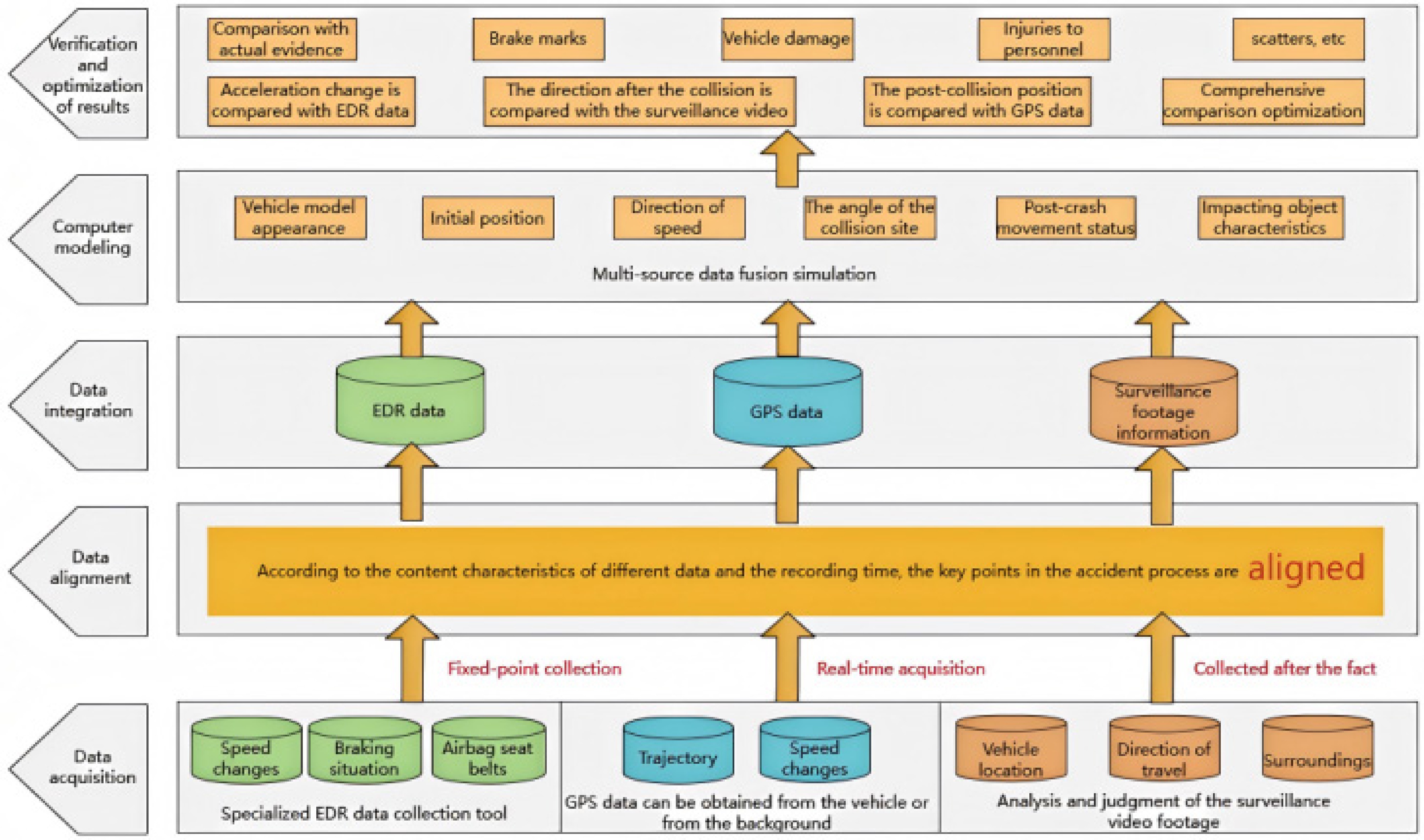
Figure 1.
Technical flow chart.
A sensitivity analysis of the key simulation parameters is carried out in this study. The results show that the simulation output is slightly sensitive to the road adhesion coefficient, collision stiffness, and tire parameters. When the road adhesion coefficient changes within ±0.1, the deviation in the vehicle's stopping position is less than 0.5 m; when the collision stiffness changes within ±10%, the deviation in the vehicle's speed is less than 1.5 km/h. This indicates that the proposed model has strong stability and is not sensitive to small-amplitude parameter disturbances.
-
On a certain date in 2023, a traffic accident occurred on a downhill section of a mountainous highway in China in which a small car ran off the road and collided with a number of people off the road. After investigation, the accident vehicle at the scene of the road surface did not leave obvious traces of braking, the vehicle's damage was more serious, and a large amount of vehicle debris was left at the scene. Staff accessed a surveillance video taken in the incident's area, with a resolution of 1,280 × 720 and a frame rate of 25 frames/s; the far end of the screen showed the process of the accident vehicle leaving the highway, as seen in Fig. 2. The EDR data were retrieved from the accident vehicle (including the speed curve, braking nodes, etc.), and GPS data, and in accordance with the method described above, were used to complete the preprocessing, laying the groundwork for the subsequent analysis.
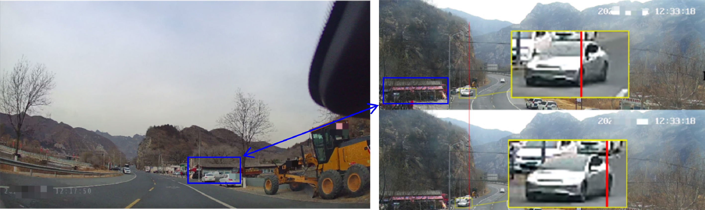
Figure 2.
On-site and vehicle surveillance video screen.
Data integration and comprehensive analysis
-
In the time alignment session, the timestamps of the EDR, GPS, and video data were extracted to construct the model using the traffic management authority's time as a benchmark. For data with temporal deviations, those with small temporal deviations were corrected for temporal and numerical trends using spline interpolation; data with noise and large time deviations were processed using Kalman filtering combined with dynamic and statistical laws to ensure consistency in the time across data sources.
In terms of spatial feature extraction and alignment, the geographic coordinates of the vehicle were first determined from the GPS data, and then the localization was refined according to the relative position of the vehicle to the environment in the video. With the help of the key time-synchronized events (in this case, they were mainly based on the vehicle's position, steering, and other information), the EDR's motion parameters were matched with the spatial information from the GPS and video footage. The main information from the EDR is shown in Table 1.
Table 1. Extracted EDR feature data.
Moment
numberHour Minute Second Vehicle's
speed
(km/h)Degree of
opening and
closing of
electric
doors (%)Brake pedal
status (0 =
released, 1 =
depressed)Master cylinder's
pressure (Bar, 205
for abnormal
alarms)Steering wheel
angle (°, left
positive, right
negative)Gear
(1 = drive,
2 = neutral,
3 = reverse,
4 = park)Distance to
the left lane
line (m)Distance to
the right lane
line (m)Driving
modes
(0 = assist,
16 = manual)−5 s 12 33 16 58.7 12 0 0 −13.9 1 2.0 −1.6 16 −4 s 12 33 17 59.4 12 0 0 −10.4 1 2.0 −1.6 16 −3 s 12 33 18 60.1 13 0 0 −8.5 1 1.6 −2.0 16 −2 s 12 33 19 61.3 13 0 0 −6.7 1 1.4 −2.1 16 −1 s 12 33 20 43.8 0 1 78 −5.1 1 2.2 −1.4 16 0 12 33 21 35.2 0 1 102 −2.1 1 0.6 0.0 16 Simulation and reconstruction
-
On the basis of the aligned data, computer graphics and physical simulation techniques were used to construct a 3D model of the accident scene. This utilized high-precision software to create a realistic vehicle model including its appearance, structure, and component layout, and considered light and shadow effects. The initial information of the vehicle's EDR and GPS track were imported, and the scene was restored. The accident process was simulated by combining the video's dynamic information. The simulation results show that the speed of the sedan before the collision was 60 km/h, and the stopping position after the collision was 3.9 m from the impact point.
Image-based and spatial measurement methods were used to quantitatively evaluate the results compared with the actual evidence. The results show that the post-collision stopping position of the car deviated by about 0.3 m, but the error does not affect the accuracy of the reconstruction results, confirming that the method shown in the article is feasible and effective. A diagram of the reconstructed scene is shown in Fig. 3.
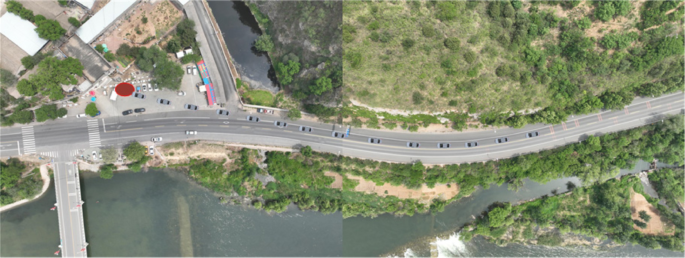
Figure 3.
Accident reconstruction results based on data alignment.
Although this study uses a typical case of a mountain road accident for verification, the proposed spatio-temporal alignment and multisource data fusion framework has strong universality. The method can be widely applied to various traffic accident scenarios, including urban intersection accidents, multivehicle collisions, vehicle–pedestrian accidents, and highway accidents. The core algorithms and simulation processes can be quickly adjusted and shifted according to the road conditions, vehicle types, and forms of collision, and thus they have good engineering generalization and application value.
The accident reconstruction performance is verified by three quantitative indicators:
(1) Speed error: Mean absolute error between the simulated speed and EDR data;
(2) Stopping position error: Euclidean distance between the simulated stopping position and the actual measured position;
(3) The process's reproduction accuracy: The coincidence rate of key time nodes (start of braking, collision, stop).
Quantitative results indicate that the speed estimation error is controlled within 1.0 km/h, the stopping position error is 0.3 m, and the recovery rate of the accident process exceeds 95%, verifying the effectiveness of the proposed method.
-
Multisource spatio-temporal alignment serves as a critical procedure in modern high-precision traffic accident reconstruction. This was achieved by implementing a complete set of standardized methods and procedural steps, ranging from the systematic acquisition and professional preprocessing of original EDR, GPS, and video data to the precise multidimensional alignment and targeted feature extraction of heterogeneous data sources, and to fine-grained computer simulation and construction of a physical model of accident scenarios, as well as the rigorous verification and iterative optimization of the simulation's results against actual on-site evidence. This integrated approach enables the effective fusion of multisource electronic data including the vehicle's dynamic parameters recorded by the EDR, GPS-based spatio-temporal positioning data and on-site video surveillance records.
This comprehensive data integration not only refines the input parameters of accident reconstruction models but also significantly elevates the overall reliability, realistic reproduction effect, and analytical efficiency of computer simulation technologies throughout the process of traffic accident reconstruction. When confronted with complex practical scenarios in accident investigation such as the partial failure of electronic recording data, inconsistent information among different data sources, and redundancy in the on-site evidence, the multisource data alignment and fusion method proposed in this paper can fully exploit the complementary advantages of various data sources, flexibly and rationally utilize all available accident information, and accurately decouple the complex causal relationships and dynamic evolution of traffic accidents for scientific judgment.
In doing so, it provides solid technical support and an objective decision-making basis for a series of works including identifying liability for traffic accidents, analyzing the causes of accidents, traffic risk prevention and control, and examining intelligent vehicles' safety performance. It also strongly drives the technological innovation and progressive development of traffic accident reconstruction technology in the era of intelligent transportation, and plays a positive role in improving the overall safety management level and intelligent governance capacity of road traffic systems, thus having important practical significance for safeguarding road traffic and enhancing the safety of public travel.
For future research directions, the focus can be placed on several key aspects, such as further improving the precision and real-time acquisition efficiency of multisource accident data through upgrading the recording equipment and optimization of the collection processes, innovating and developing more adaptive and efficient data alignment algorithms to cope with the increasing complexity of accident data sources, enhancing the adaptability and generalizability of reconstruction models to extremely complex accident scenarios such as multivehicle chain collisions and accidents related to unusual road conditions, and deepening the theoretical research into and construction of technical systems of multisource heterogeneous data fusion. Through in-depth research in these aspects, the technical framework of traffic accident reconstruction can be continuously improved and perfected, making the reconstruction results more accurate, comprehensive, and reliable, thus contributing to the scientific prevention and control of road traffic accidents and all-round road traffic safety.
-
The authors confirm their contributions to the paper as follows: conceptualization, methodology, writing – original draft: Yuan Q; Supervision, writing – review and editing, funding acquisition: Ji W; Data curation, formal analysis, software simulation: Cheng R, Ye S; investigation, case data collection: Wang T; Resources, engineering verification, and result validation: Cui T. All authors reviewed the results and approved the final version of the manuscript.
-
The raw EDR, GPS, and surveillance video data involved in this study are derived from real traffic accident cases and are restricted by privacy and judicial confidentiality requirements, and thus are not publicly available. Relevant processed data, simulation models and analysis codes can be obtained from the corresponding author upon reasonable academic request.
-
The authors declare that they have no conflict of interest.
- Copyright: © 2026 by the author(s). Published by Maximum Academic Press, Fayetteville, GA. This article is an open access article distributed under Creative Commons Attribution License (CC BY 4.0), visit https://creativecommons.org/licenses/by/4.0/.
-
About this article
Cite this article
Yuan Q, Ji W, Cheng R, Ye S, Wang T, et al. 2026. Multisource data alignment and fusion for traffic accident reconstruction: integrating EDR, GPS, and video recordings. Digital Transportation and Safety 5(3): 229−236 doi: 10.48130/dts-0026-0018 

Multisource data alignment and fusion for traffic accident reconstruction: integrating EDR, GPS, and video recordings
- Received: 14 March 2026
- Revised: 23 June 2026
- Accepted: 06 July 2026
- Published online: 30 September 2026
Abstract: Traffic accident reconstruction is essential for reducing accidents and traffic safety prevention. At present, data from event data recorder (EDR), global positioning system (GPS), and on-site video recordings have become important evidence for traffic accident reconstruction. This paper first reviews and analyzes the mainstream theories and methods of existing traffic accident reconstruction, clarifying their technical characteristics and practical application problems. On this basis, a computer simulation-based traffic accident reconstruction method is proposed, which integrates and aligns vehicle-related EDR data, GPS data, and on-site video parameters, and the method is applied to the reconstruction analysis of actual traffic accident cases. The real case verification results show that under the proposed multisource data alignment and fusion framework, the vehicle speed reconstruction error is less than 1.0 km/h, the final parking position error is only 0.3 m, and the accuracy of reproducing the accident process exceeds 95%. EDR, GPS, and on-site video data provide reliable parameter support for accident reconstruction models, which effectively improves the reliability, authenticity, and analytical efficiency of computer simulation-based reconstruction. Furthermore, in complicated situations where some electronic records are invalid and the on-site evidence is abundant, the computer simulation technique can combine the available accident information to precisely analyze and identify the accident process, showing its importance. Moreover, the suggested approach can establish a virtual–real integrated and credible accident scenario, offering a dependable basis for examining the safety of intelligent vehicles.