












-
Unmanned aerial vehicles (UAVs)[1] are now widely deployed across diverse applications, such as communication services[2], reconnaissance and surveillance[3,4], search and rescue[5,6], ground mapping[7], and agriculture[8,9]. Among them, for military and civilian applications, searching for and tracking targets in a given region has great demand and has been heavily researched[10,11]. In addition, with accelerated urbanization around the world, UAVs are increasingly being used for various tasks in urban environments. The use of UAVs for searching for and tracking targets in urban environments has received continuous attention[12,13].
Conventional target tracking typically follows a predict-then-plan paradigm: The target's future motion is first estimated, and the UAV's actions are then chosen to increase the future detection likelihood or reduce state uncertainty. This paradigm is instantiated across recent work. Yu et al.[14] proposed a path planner for tracking a moving target in urban contexts using a dynamic occupancy grid and Bayesian filtering, coupled with a tree-search strategy that maximizes the cumulative detection probability over a finite horizon. Cook et al.[15] improved ground-target observation in urban settings by learning a data-driven motion model from observed behaviors and fusing it with a traditional model to refine trajectory prediction. Yao et al.[16] cast tracking as a model predictive control (MPC) problem and solved it with an enhanced grey wolf optimizer to obtain multi-UAV trajectories, while predicting target motion via an unscented Kalman filter. Qi et al.[17] assumed multiple motion models and applied an interacting multiple model (IMM) filter with state–vector fusion for prediction. Hu et al.[18] framed the search for and tracking of an unknown ground target as a fuzzy multiobjective path planning problem within a distributed predictive control framework, using an extended Kalman filter (EKF) for road-constrained motion and probability estimates near intersections. Collectively, these studies exemplify the predict-then-plan approach, differing in their predictive models and planning schemes yet sharing reliance on model-based state estimation to guide the choice of action.
Learning-based methods have also been explored for target tracking[19,20]. Bhagat et al.[21] developed a deep reinforcement learning (DRL) controller based on deep Q-networks (DQN) for urban target tracking. To improve generalization under uncertain target motion, Li et al.[22] introduced Meta-TD3, which couples meta-learning with twin delayed deep deterministic policy gradient (TD3). Li et al.[23] proposed an online path planner grounded in the deep deterministic policy gradient (DDPG) to handle maneuvering targets and obstacle avoidance. For multi-UAV tracking in dynamic environments where direct target information is limited, Jiao et al.[24] proposed a multiagent reinforcement learning algorithm named MAA2CE. By integrating prioritized experience replay and network evolution mechanisms, this approach effectively addresses the multitarget tracking problem for UAV swarms operating in dynamic environments.
Despite extensive progress, comparatively few studies have focused on targets that actively evade tracking. Evasive maneuvers in complex environments pose a critical challenge because of their diversity and adaptability, manifested through high-speed maneuvering[25], dynamic trajectory uncertainty[26], occlusion avoidance[27], and multitarget cooperative evasion[28], with some targets using adversarial strategies[29,30]. Quintero et al.[31] formulated a method of UAV tracking of an evasive ground vehicle using a model of predictive control with moving horizon estimation, where the target's policy maximizes separation from UAVs. In a related game-theoretic setting[32], the target maximizes distance while UAVs minimize it, and the UAVs infer the target's intelligence levels from observations to adapt their policies. Zhang et al.[33] developed a closed-loop control strategy based on a minimax search tree with pruning informed by structural properties of the Kalman filter (KF), planning nongreedy control sequences to minimize worst-case target estimation uncertainty. Mbam et al.[26] proposed a three-dimensional optimal tracking algorithm with a two-step predictive control strategy to follow ground targets that execute sharp evasive turns. When the target's speed exceeds the UAV's flight speed, a double-delayed deep deterministic policy gradient method has been used for multi-UAV cooperative pursuit of high-speed targets[25]. Within a pursuit–evasion framework where the target uses artificial potential fields for escape, Chen et al.[29] developed an encirclement strategy that integrates DRL with trajectory prediction to enable multi-UAV pursuit and encirclement in cluttered environments.
Even with these advances, maintaining continuous tracking of highly evasive targets remains difficult. Once contact is lost, reacquisition is costly and uncertain, as goal-directed adversarial maneuvers undermine reactive, kinematics-only trackers. This motivates intent reasoning: By inferring high-level goals and constraints, forecasting strategic trajectories, and quantifying uncertainty over intentions, a tracker can plan anticipatory information-seeking motions that preserve contact, resist deception, and improve continuity and robustness in contested environments.
Intent inference has been actively studied in autonomous driving[34,35] and human–robot interaction[36]. Karasev et al.[37] modeled pedestrian intention as a policy within a Markov decision process under approximately rational behavior, using a Rao–Blackwellized filter to forecast long-term motion. In another line of work[38], vehicle intention is represented by discrete high-level behaviors together with future trajectories, and an end-to-end learnable neural network jointly predicts both. Human behavior and intention have also been captured via an intention-driven dynamics model that encodes intention-dependent dynamics in latent states from noisy, high-dimensional observations[39]. Similarly, Jain et al.[40] defined intention as the agent's intended goal and behavior as goal-directed actions with varying rationality, and used recursive Bayesian filtering over multiple nonverbal cues to infer human intentions.
Building on these insights, this paper addresses the continuous tracking of a moving ground target exhibiting evasive behavior in urban environments using a single UAV. Evasive maneuvers can cause persistent loss of contact, especially under occlusions and limited sensing. To mitigate the constraints of limited UAV resources, we deploy ground sensors[41,42] throughout the urban area to augment situational awareness and assist reacquisition when the target is lost. We model the target's intention as its goal region and infer candidate goal regions from the observed trajectories; these inferred intentions then condition the prediction of the target's future motion. Finally, we plan the UAV's actions to maximize the cumulative future detection probability, thereby improving tracking continuity against evasive targets in urban settings.
The main contributions of this work are as follows.
(i) Continuous tracking of evasive targets is enabled through explicit intent inference. When contact is lost, plausible escape trajectories are generated by sampling inferred goal-region intentions, providing principled guidance for anticipatory UAV planning and allowing rapid reacquisition and tracking resumption.
(ii) A method is proposed for real-time estimation and update of the target's behavior parameters from streaming trajectory observations when these parameters are initially unknown. In simulation, real-time parameter updates are shown to significantly enhance tracking continuity and overall UAV performance.
-
This study addresses the problem of using a UAV
$ U $ $ T $ $ \Omega $ $ M=(V,E) $ $ C $ $ M=(V,E) $ $ e(e\in E) $ $ v(v\in V) $ $ C $ $ c(c\in C) $ $ {S}_{c} $ $ R_{S}^{c} $ $ {S}_{c} $ 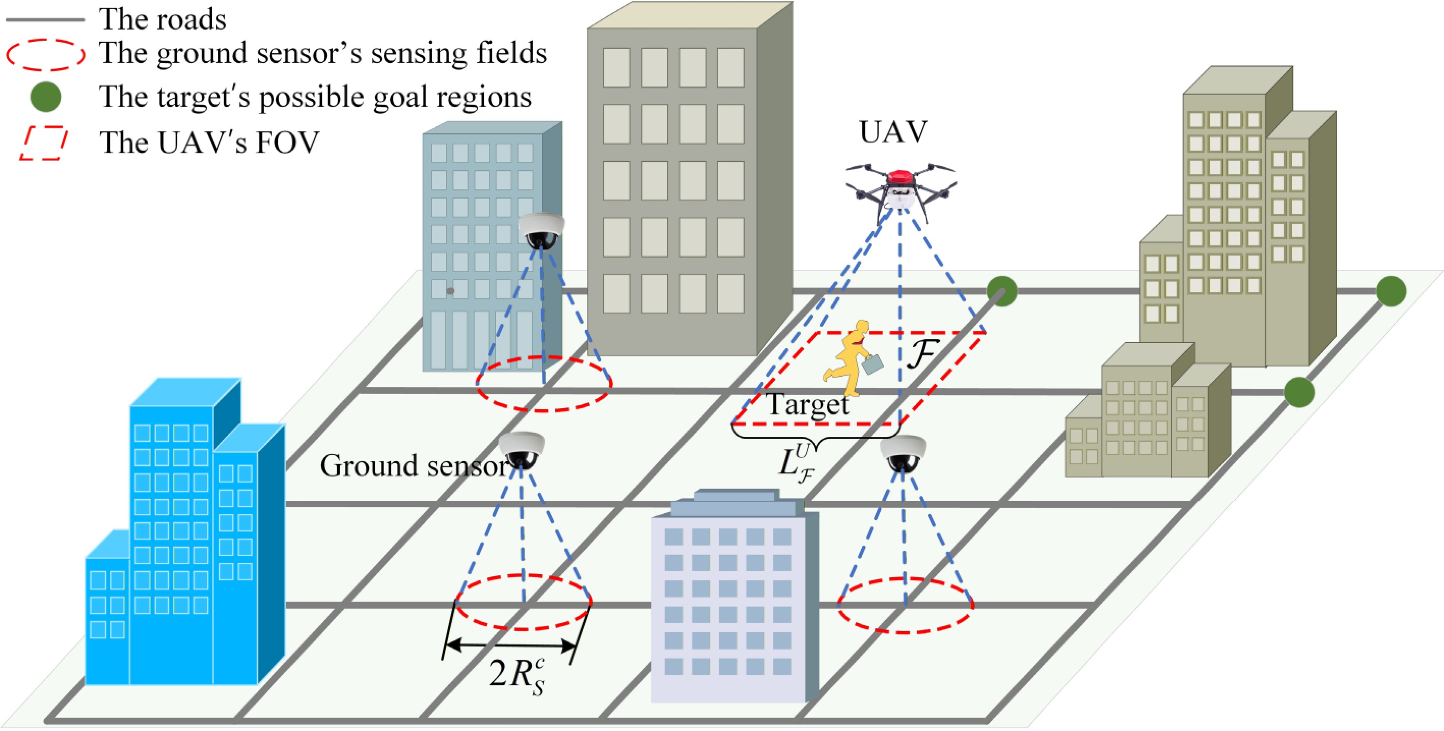
Figure 1.
Schematic diagram of the problem scenario.
The target is assumed to possess a high-level intention of reaching a specific goal region
$ {g}_{T} $ $ {g}_{T}\in \mathbf{g} $ $ \mathbf{g} $ $ {g}_{T} $ $ \mathcal{F} $ $ \mathcal{F} $ $ L_{\mathcal{F}}^{U} $ Let
$ x_{T}^{t} $ $ x_{U}^{t} $ $ P(x_{T}^{t}) $ $ P(x_{U}^{t}) $ $ x_{T}^{t} $ $ x_{U}^{t} $ $ {D}_{t} $ $ P({D}_{t}|x_{T}^{t},x_{U}^{t}) $ $ x_{U}^{t} $ $ x_{T}^{t} $ $ P({D}_{t}|x_{T}^{t},x_{U}^{t}) $ $ P({D}_{t}|x_{T}^{t},x_{U}^{t})=\left\{\begin{array}{l} 1\;\;\text{if}\;\;x_{T}^{t}\in {\mathcal{F}}_{t}\\ 0\;\;\text{else} \end{array} \right.$ (1) where
$ {\mathcal{F}}_{t} $ $ t $ The UAV aims to maintain persistent tracking of the target as it moves toward its goal region. This objective is posed as an optimization problem as follows:
$ \pi _{U}^{*}=\underset{{\pi }_{U}}{\arg \max }\int \limits_{x_{T}^{t}}^{{g}_{T}}P({D}_{T}|x_{T}^{t},x_{U}^{t},\Omega )P(x_{T}^{t})dx_{T}^{t} $ (2) where
$ {\pi }_{U} $ -
We achieve continuous tracking through a closed-loop pipeline: (i) Update the posterior over the target's intentions from the latest observations; (ii) sample future target trajectories conditioned on this posterior; and (iii) plan the UAV's actions via a Monte Carlo tree search (MCTS)[43] to maximize the expected cumulative detection under the generative model. After executing the chosen action, new observations update the posterior and the search tree is incrementally reused and extended. This belief–space coupling provides feedback without requiring an intractable joint optimization, and is essential for robustness under multimodal, evasive behavior. The system's framework is illustrated in Fig. 2.
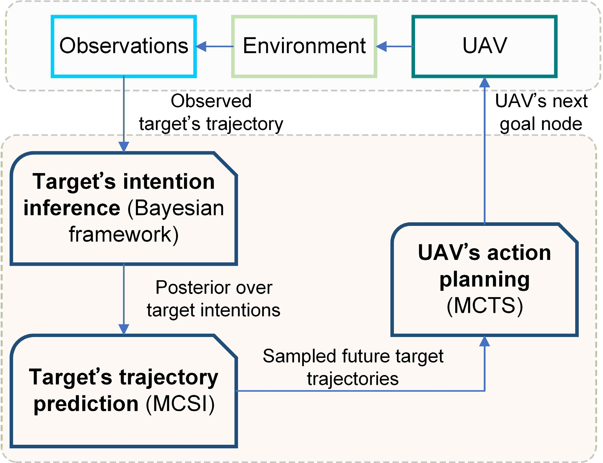
Figure 2.
System framework.
Target's intention inference
-
A Bayesian scheme is used to sequentially estimate the target's intention. With
$ x_{T}^{0:t} $ $ P({g}_{T}|x_{T}^{0: t})\propto P(x_{T}^{t}|x_{T}^{t-1},{g}_{T})P({g}_{T}|x_{T}^{0: t-1}) $ (3) Under the inference scheme in (3), the target's intention is updated sequentially at each time step. To simplify the intention inference process, the target intention is updated only once when the movement of the target from node
$ v_{T}^{c} $ $ v_{T}^{n} $ $ P({g}_{T}|x_{T}^{0: t})\propto P(v_{T}^{n}|v_{T}^{c},{g}_{T},\Omega )P({g}_{T}|x_{T}^{0: t-1}) $ (4) where
$ P(v_{T}^{n}|v_{T}^{c},{g}_{T},\Omega ) $ $ P(v_{T}^{n}|v_{T}^{c},{g}_{T},\Omega )=\dfrac{1}{\eta }\exp (-\beta (\rho (v_{T}^{c},v_{T}^{n},{g}_{T})-\rho (v_{T}^{c},{g}_{T}))),\beta \gt 0 $ (5) where
$ v_{T}^{c} $ $ v_{T}^{n} $ $ \rho (v_{T}^{c},v_{T}^{n},{g}_{T}) $ $ v_{T}^{c} $ $ v_{T}^{n} $ $ {g}_{T} $ $ \rho (v_{T}^{c},{g}_{T}) $ $ v_{T}^{c} $ $ {g}_{T} $ $ \eta $ $ \eta =\sum \limits_{v_{T}^{n}\in \chi (v_{T}^{c})}\exp (-\beta (\rho (v_{T}^{c},v_{T}^{n},{g}_{T})-\rho (v_{T}^{c},{g}_{T}))) $ (6) where
$ \chi (v_{T}^{c}) $ $ v_{T}^{c} $ The intention posterior is updated only when an observed transition between adjacent road network nodes provides new information regarding the target's route choice. If the target remains stationary or moves within the same road segment, the posterior over candidate goal regions is retained because no new intersection-level directional decision has been observed.
According to Equation (5), we assume that the target behaves as a rational agent, i.e., it always selects the shortest path to the goal region with the highest probability. Moreover, Equation (5) embodies the assumptions of goal-directed rationality and stochastic decision-making, while its role as a likelihood function ensures consistency with Bayesian inference. This integration enables the framework to robustly infer evasive targets' intentions by balancing prior knowledge with real-time behavioral observations.
When inferring the intention of the target through Equation (4), the behavior parameter
$ \beta $ $ \beta $ $ {\tau }_{t} $ $ {\hat{\beta }}_{n}={\hat{\beta }}_{n-1}+\delta \beta \dfrac{\partial \ln (P({v}_{n-1}|{v}_{n-2},{v}_{n},\Omega ))}{\partial \beta } $ (7) where
$ {v}_{n-1} $ $ {v}_{n-2} $ $ {v}_{n} $ $ {\tau }_{t} $ $ {\hat{\beta }}_{n} $ $ \beta $ $ \delta \beta $ Target's trajectory prediction
-
Building on the inferred intentions, we introduce a trajectory prediction method that uses a Monte Carlo sampling technique to estimate the target's future trajectory. We name this method the Monte Carlo sampling technique with target intention (MCSI). In the MCSI approach, we sample
$ N_{T}^{MC} $ $ v_{T}^{l} $ $ {g}_{i} $ $ {g}_{i}\in \mathbf{g} $ $ v_{T}^{l} $ $ N_{i}^{MC} $ $ {g}_{i} $ $ N_{i}^{MC}=N_{T}^{MC}\times P({g}_{i}|x_{T}^{0: t}) $ (8) Each trajectory sample assumes the target moves at the speed measured at its latest observation. The local goal node of the target is selected using the probability calculated in (5) with the estimated target behavior parameter
$ {\hat{\beta }}_{n} $ $ {t}_{T}({v}_{i}) $ $ {t}_{T}({v}_{j}) $ $ {v}_{i} $ $ {v}_{j}({v}_{j}\in \chi ({v}_{i})) $ $ [{t}_{1},{t}_{2}] $ If the target transitions from
$ {v}_{i} $ $ {v}_{j} $ $ {v}_{i} $ $ {v}_{j} $ $ [{t}_{1},{t}_{2}] $ $\begin{split}& P(E({v}_{i},{v}_{j},{t}_{1},{t}_{2}))=\\&\begin{cases} 1.0,\;\;\text{if}\;({t}_{1}\geq {t}_{T}({v}_{i})\;\text{and}\;{t}_{2}\leq {t}_{T}({v}_{j}))\;\text{or}({t}_{1}\leq {t}_{T}({v}_{i})\;\text{and}\;{t}_{2}\geq {t}_{T}({v}_{i}))\\ \dfrac{{t}_{2}-{t}_{T}({v}_{i})}{{t}_{2}-{t}_{1}},\;\;\text{elif}\;{t}_{2}\geq {t}_{T}({v}_{i})\;\text{and}\;{t}_{2}\leq {t}_{T}({v}_{j})\\ \dfrac{{t}_{T}({v}_{j})-{t}_{1}}{{t}_{2}-{t}_{1}},\;\;\text{elif}\;{t}_{1}\geq {t}_{T}({v}_{i})\;\text{and}\;{t}_{1}\leq {t}_{T}({v}_{j})\\ 0.0,\;\;\text{else} \end{cases} \end{split}$ (9) where
$ E({v}_{i},{v}_{j},{t}_{1},{t}_{2}) $ $ {v}_{i} $ $ {v}_{j} $ $ [{t}_{1},{t}_{2}] $ If the target transitions from
$ {v}_{i} $ $ {v}_{j} $ $ {v}_{j} $ $ {v}_{i} $ $ [{t}_{1},{t}_{2}] $ $ P(E({v}_{i},{v}_{j},{t}_{1},{t}_{2}))=\begin{cases} 1.0,\;\text{if}\;({t}_{2}\geq {t}_{T}({v}_{i})\;\text{and}\;{t}_{1}\leq {t}_{T}({v}_{j}))\\ 0.0,\;\text{else} \end{cases} $ (10) Algorithm 1 shows the target trajectory prediction method using MCSI.
Table 1. Target trajectory prediction algorithm (MCSI)
Input: Urban road graph $ M=(V,E) $, possible goal regions $ {g}_{i}({g}_{i}\in \mathbf{g}) $, ground sensor set $ C $, target's position $ x_{T}^{t} $, UAV's position $ x_{U}^{t} $, the number of trajectory samples $ N_{T}^{MC} $ Output: The probability $ P(E({v}_{i},{v}_{j},{t}_{1},{t}_{2})) $ 1: //The target does not reach its goal region 2: while $ x_{T}^{t} $ not at $ {g}_{T} $ do 3: //Target is in the UAV's FOV or in the sensing field of ground sensors 4: if $ x_{T}^{t}\in {F}_{t} $ or $ x_{T}^{t}\in {S}_{c} $ then 5: //Update target's intention 6: $ P({g}_{T}|x_{T}^{0: t})\propto P(v_{T}^{n}|v_{T}^{c},{g}_{T},\Omega )P({g}_{T}|x_{T}^{0: t-1}) $ 7: // Sampled trajectories 8: $ \Theta \leftarrow \varnothing $ 9: for each $ {g}_{i}\in \mathbf{g} $ do 10: // Calculate the number of trajectories 11: $ N_{i}^{MC}=N_{T}^{MC}P({g}_{i}|x_{T}^{0: t}) $ 12: for $ i=1,2,...,N_{i}^{MC} $ do 13: Draw a sample trajectory ${\mathcal{T}}$ from node $ v_{T}^{l} $ to node $ {g}_{i} $ using (5) 14: $\Theta \leftarrow \Theta \cup {\mathcal{T}}$ 15: end for 16: end for 17: for each ${\mathcal{T}} \in \Theta $ do 18: // $ {v}_{j} $ is the next node of $ {v}_{i} $ in the trajectory ${\mathcal{T}}$ 19: for each $({v_i},{v_j}) \in {\mathcal{T}}$ do 20: Record the times $ {t}_{T}({v}_{i}) $ and $ {t}_{T}({v}_{j}) $ 21: end for 22: end for 23: end if 24: Calculate $ P(E({v}_{i},{v}_{j},{t}_{1},{t}_{2})) $ using (9) and (10) 25: end while UAV's planning methods
Objective function
-
The mission objective is persistent tracking of the target, as defined in Eq. (2). However, this objective function cannot be accurately calculated because the position of the goal region
$ {g}_{T} $ $ {g}_{T} $ $ \pi _{U}^{*}=\underset{{\pi }_{U}}{\arg \max }\int P({D}_{T}|E({v}_{i},{v}_{j},{t}_{1},{t}_{2}),x_{U}^{t},\Omega )P(E({v}_{i},{v}_{j},{t}_{1},{t}_{2}))dt $ (11) By discretizing time, we define the UAV's objective to maximize the cumulative probability of detecting the target over the next
$ {H}_{p} $ $ \pi _{U}^{*}=\underset{{\pi }_{U}}{\arg \max }\sum \limits_{k=1}^{{H}_{p}}\left\{{\gamma }^{k}P({D}_{T}|E({v}_{i},{v}_{j},{t}_{1},{t}_{2}),x_{U}^{t+k},\Omega )\right.\left.P(E({v}_{i},{v}_{j},{t}_{1},{t}_{2}))\right\} $ (12) where
$ \gamma (0 \lt \gamma \lt 1) $ In an urban road graph, when the UAV is at node
$ v_{U}^{n}(t) $ $ v_{U}^{*}(t+1) $ $ \begin{aligned}v_{U}^{*}(t+1)&=\underset{v_{U}^{n}(t+1)\in \chi (v_{U}^{n}(t))}{\arg \max }\sum \limits_{k=0}^{{H}_{p}-1}\left\{{\gamma }^{k}P(E(v_{U}^{n}(t+k),\right.\\ & \left. v_{U}^{n}(t+k+1), {t}_{U}(v_{U}^{n}(t+k)), {t}_{U}(v_{U}^{n}(t+k+1)))\right\} \end{aligned} $ (13) where
$ {t}_{U}(v_{U}^{n}(t+k)) $ $ {t}_{U}(v_{U}^{n}(t+k+1)) $ $ v_{U}^{n}(t+k) $ $ v_{U}^{n}(t+k+1) $ Monte Carlo tree search-based planning method
-
Since both the target and the UAV move on the road graph
$ M=(V,E) $ $ M=(V,E) $ In the MCTS method, the search tree is established with the node
$ v_{U}^{n}(t) $ $ N_{p}^{MCTS} $ (1) Selection: Beginning at the root node, the node with the highest upper confidence bounds for trees (UCT) value is recursively selected and traversed down the tree. This process continues until a child node
$ \overline{v} $ $ {\overline{v}}_{i}\in \chi (\overline{v}) $ $ \text{UCT}({v}_{i},v)=\dfrac{Q({v}_{i})}{N({v}_{i})}+\lambda \sqrt{\dfrac{\log (N(v))}{N({v}_{i})}}, {v}_{i}\in \chi (v) $ (14) where
$ Q({v}_{i}) $ $ {v}_{i} $ $ N({v}_{i}) $ $ {v}_{i} $ $ \lambda $ (2) Expansion: One of the unvisited child nodes
$ {\overline{v}}_{i} $ (3) Simulation: Sample a trajectory with the start node
$ {\overline{v}}_{i} $ $ {H}_{p} $ (4) Backpropagation: The outcome in Step (3) is backpropagated through the selected nodes to update their statistics.
The next goal node of the UAV is derived from the following equation:
$ v_{U}^{*}(t+1)=\underset{v_{U}^{n}(t+1)\in \chi (v_{U}^{n}(t))}{\arg \max }\dfrac{Q(v_{U}^{n}(t+1))}{N(v_{U}^{n}(t+1))} $ (15) The MCTS-based planning method is summarized in Algorithm 2.
Table 2. MCTS-based planning method.
Input: Urban road graph $ M=(V,E) $, possible goal regions $ {g}_{i}({g}_{i}\in \mathbf{g}) $ and posterior probability $ P({g}_{i}|x_{T}^{0: t}) $, target's position $ x_{T}^{t} $, UAV's position $ x_{U}^{t} $, the maximum number of tree search iterations $ N_{p}^{MCTS} $, simulation horizon $ {H}_{p} $, constant $\lambda $ Output: The next goal node of the UAV, $ v_{U}^{*}(t+1) $ 1: //Target is not in the UAV's FOV 2: if $ x_{T}^{t}\notin {F}_{t} $ then 3: Create root node $ {v}_{0} $ with node $ v_{U}^{n}(t) $, whose parent is None 4: for $ i=1,2,... $,$ N_{p}^{MCTS} $ do 5: $ {v}_{l}\leftarrow $ TREEPOLICY$ ({v}_{0}) $ 6: $ {r}_{l}\leftarrow $ DEFAULTPOLICY$ ({v}_{l}) $ 7: BACKUP$ ({v}_{l},{r}_{l}) $ 8: end for 9: $ v_{U}^{*}(t+1)\leftarrow $ BESTCHILD$ ({v}_{0},0) $ 10: end if 11: function TREEPOLICY(v) 12: while v is a nonterminating state do 13: if v is not fully expanded then 14: return EXPAND(v) 15: else 16: v←BESTCHILD(v,$ \lambda $) 17: end if 18: end while 19: return v 20: end function 21: function EXPAND(v) 22: Choose one of the unvisited child nodes $ {\overline{v}}_{i} $, $ {\overline{v}}_{i}\in \chi (v) $ 23: return $ {\overline{v}}_{i} $ 24: end function 25: function BESTCHILD(v, $ \lambda $) 26: return $ \underset{{v}_{i}\in \chi (v)}{\arg \max }\dfrac{Q({v}_{i})}{N({v}_{i})}+\lambda \sqrt{\dfrac{\log (N(v))}{N({v}_{i})}} $ 27: end function 28: function DEFAULTPOLICY($ (v_{U}^{n}(t+k)) $) 29: Randomly sampling a goal region $ {g}_{i} $ according to the probability $ P({g}_{i}|x_{T}^{0: t}) $ 30: Draw a sample trajectory $ {\mathcal{T}} $from node $ v_{U}^{n}(t+k) $to node $ {g}_{i} $ using (5) with speed $ V_{\max }^{U} $ 31: $ \begin{aligned}r\leftarrow \sum \limits_{i=0}^{{H}_{p}-1}{\gamma }^{i}P(E(v_{U}^{n}(t+i),v_{U}^{n}(t+i+1), {t}_{U}(v_{U}^{n}(t+i)),{t}_{U}(v_{U}^{n}(t+i+1)))) \end{aligned} $ 32: return r 33: end function 34: function BACKUP(v, r) 35: while v is not None do 36: $ N(v)\leftarrow N(v)+1 $ 37: $ Q(v)\leftarrow Q(v)+r $ 38: $ v\leftarrow $ parent of $ v $ 39: end while 40: end function -
We develop an urban region of size
$500 \text{ m}\times 500\text{ m}$ $ {r}_{c} $ $R_{S}^{c}=20\text{ m}$ $V_{\max }^{U}=5\text{ m/s}$ $L_{F}^{U}=15\text{ m}$ To simulate the motion behavior of a target in an urban environment and validate the target tracking algorithms, we develop a motion behavior model for the target. The target's behavior consists of two components: Global motion behavior and evasive behavior. For the target's global motion behavior, the target moves along roads at a constant speed
$V_{T}^{g}=2\text{ m/s}$ $ \beta $ ${T}_{e}=10\text{ s}$ ${T}_{g}=20\text{ s}$ $ {T}_{g} $ $V_{T}^{g}=2\text{ m/s}$ $ {T}_{e} $ $V_{T}^{e}=7\text{ m/s}$ In the trajectory prediction methods, we set
$ N_{T}^{MC}=100 $ $ {H}_{p}=10 $ $ \gamma =0.7 $ $ N_{p}^{MCTS}=200 $ $ \lambda =1/\sqrt{2} $ $ \beta $ $ {\hat{\beta }}_{0}=0.05 $ $ \delta \beta $ Comparison results
-
In this subsection, we compare four different trajectory prediction methods to highlight the advantages of the target's intention inference.
(i) MCSI*: The target trajectory is predicted by the Monte Carlo sampling technique with the target's intention, where the target behavioral parameter
$ \beta $ (ii) MCSI-
$ {\hat{\beta }}_{0} $ $ \beta $ $ {\hat{\beta }}_{0} $ (iii) MCS: This method is a variation of MCSI*, where there is no intention inference. In MCS, the target has the same probability of going to all goal regions.
(iv) MCSRM: This target trajectory prediction method does not consider the intention of the target. Only the target motion model is considered. We name this target trajectory prediction method the Monte Carlo sampling technique with the random motion (MCSRM) model. In the MCSRM model, except that the sampling trajectory is done differently, the rest is the same as MCSI. In MCSRM, we sample
$ N_{T}^{MC}=100 $ $ v_{T}^{l} $ $ H_{T}^{R} $ $ N_{T}^{MC}=100 $ $ H_{T}^{R}=25 $ $ p_{T}^{e}=0.7 $ $ p_{T}^{e}=0.7 $ In all four methods described above, the planning component is MCTS. Therefore, in subsequent references to these methods, we will not restate the planning method. In addition, we additionally propose four planning methods, namely the random planning method (RDM), the optimal planning method (OPT), the Deep Q-networks (DQN)[21] and the minimax search tree (MST)[33], as comparative benchmarks. RDM selects the next goal node uniformly at random and serves as a lower bound. OPT assumes oracle knowledge of the target's next goal node and uses it as the UAV's next goal, serving as an upper bound. DQN trains an end-to-end policy to control the UAV for tracking. MST determines the UAV's actions via minimax tree search, predicting target states with a Kalman filter.
The performance metric we compare is the ratio of the time the target is tracked,
$ {T}_{track} $ $ {T}_{total} $ $ TKP=\dfrac{{T}_{track}}{{T}_{total}} $ (16) For each method, we run 100 random test experiments and calculate the average of the performance metric. As shown in Fig. 3, when the planning method is MCTS, in MCSI-
$ {\hat{\beta }}_{0} $ $ \hat{\beta } $ $ \beta =0.1 $ 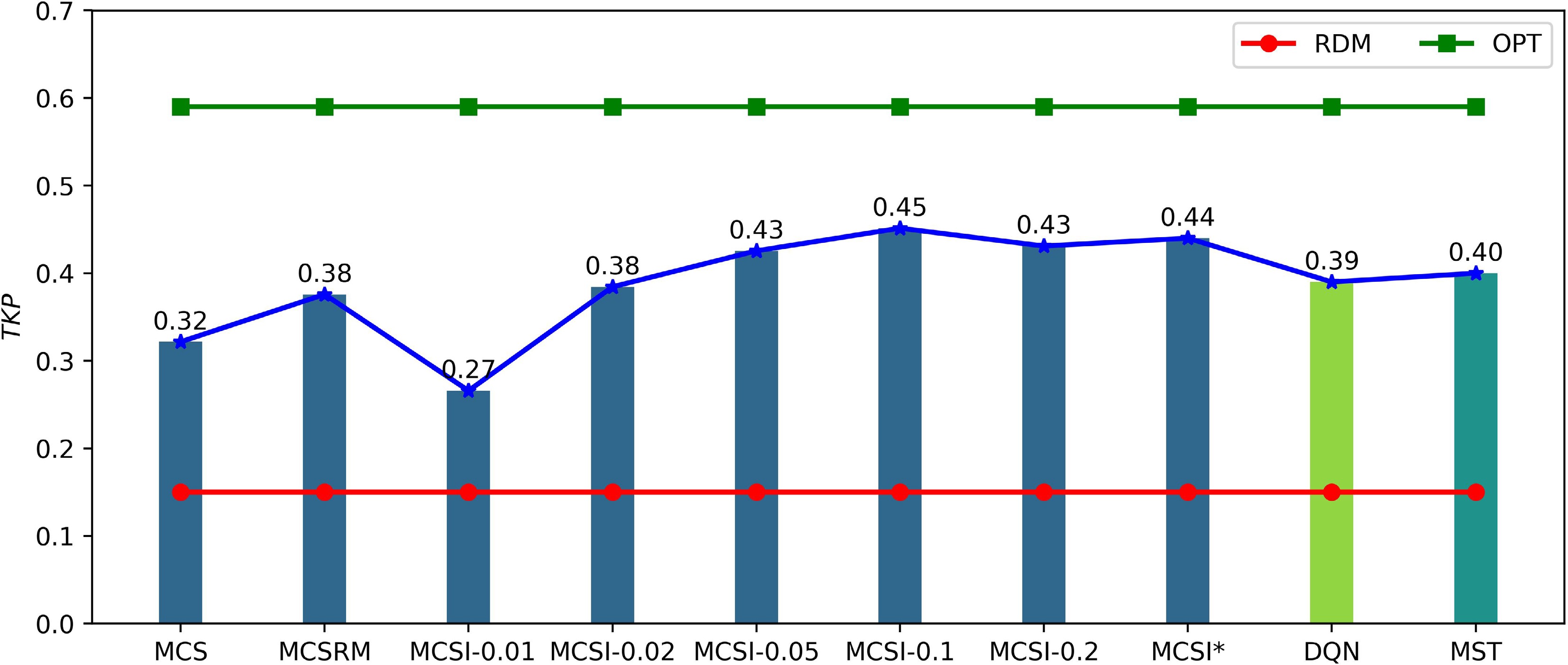
Figure 3.
The tracking performance of different methods.
Furthermore, when the planning and prediction methods differ, MCSI* demonstrates superior target tracking performance compared with DQN and MST. The superiority of MCSI* indicates that explicitly modeling the target's behavior and fusing intention inference with Monte Carlo trajectory sampling yields more informative predictions and more effective control than either a fixed predictive model (MST) or a policy learned without explicit intention modeling (DQN).
The methods RDM and OPT do not incorporate trajectory prediction, resulting in their outcomes remaining unaffected by the trajectory prediction techniques applied.
Table 1 summarizes nonparametric significance testing using the Mann–Whitney U test to compare MCS, MCSRM, DQN, and MST against MCSI*. The table reports, for each method, the mean and standard deviation of target tracking performance, together with the U statistic (vs MCSI*) and one-sided p-value. MCSI* achieves the highest mean score, although standard deviations are comparable across methods. For every pairwise comparison, U > 5,000 and one-sided p < 0.05, supporting the directional hypothesis that MCSI* outperforms the baselines. These findings corroborate the superiority of MCSI* and suggest that the gains arise from improved central performance rather than experimental random error.
Table 1. Statistical significance results.
Statistical
indicatorsMean Standard
deviationU-statistic One-sided
p-valueMCS 0.32 0.15 6,912 0.000002 MCSRM 0.38 0.17 6,158 0.002340 DQN 0.39 0.18 5,927 0.011790 MST 0.40 0.17 5,678 0.048912 MCSI* 0.44 0.18 5,000 0.500488 In a test experiment shown in Fig. 4, at
$t $ $ t $ 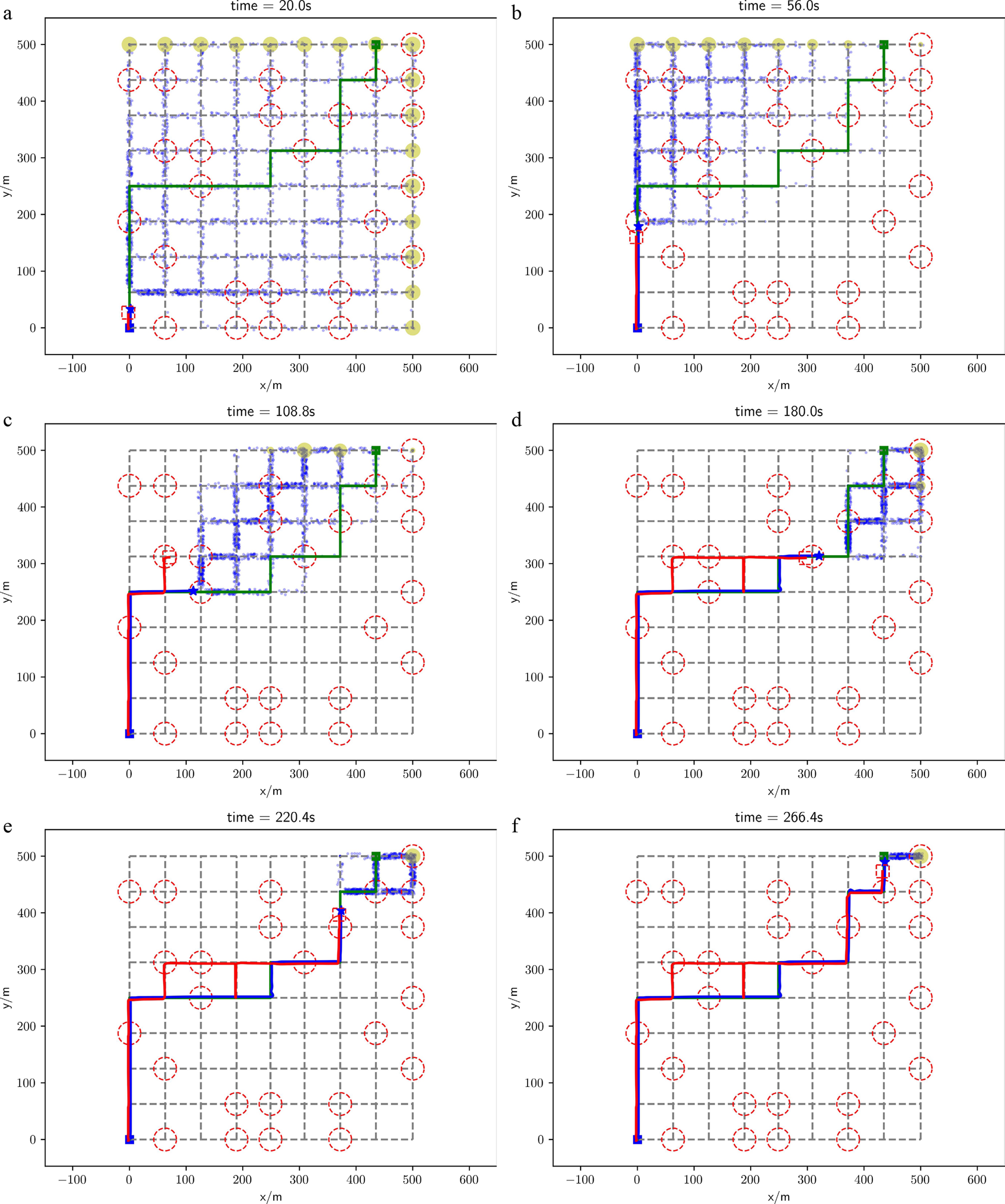
Figure 4.
Target tracking process in a test experiment. The target prediction method is MCSI*, and the UAV planning method is the MCTS-based planning method. The blue star represents the position of the target, while the dashed red square denotes the FOV of the UAV. The square blue block indicates the target's starting region, and the green square marks the actual goal region of the target. The red dashed circles represent the sensing fields of the ground sensors. The blue solid line illustrates the trajectory of the target, whereas the red solid line depicts the path taken by the UAV. The green solid line shows the planned global path from the target's starting region to its goal region. The blue dots signify the predicted positions of the target, and the yellow circles indicate the potential predicted goal regions of the target, with larger circles representing a higher likelihood of being the target's goal region.
As shown in Fig. 5, when the UAV or ground sensor observes the target moving between two nodes, the value of
$ \hat{\beta } $ $ \hat{\beta } $ $ \hat{\beta } $ $ \hat{\beta } $ $ \hat{\beta } $ $ \beta $ 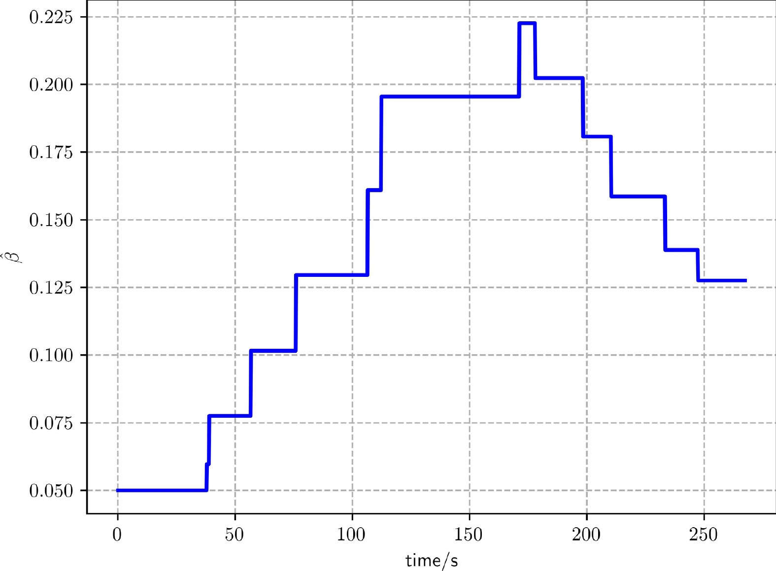
Figure 5.
The curve of the estimate of the target behavior parameter throughout the tracking process in Fig. 4.
Results with different target's behaviors
-
In this subsection, we examine the impact of the target's behaviors on target tracking performance. Specifically, we focus on both the global motion behavior and the evasive behavior of the target. The global motion behavior is influenced by the parameter
$ \beta $ $ \beta $ $ V_{T}^{e} $ $ {T}_{e} $ $ {T}_{e} $ As shown in Fig. 6, the target tracking performances under MCSRM, DQN, MST and MCSI* improve as the value of
$ \beta $ $ \beta $ $ \beta $ 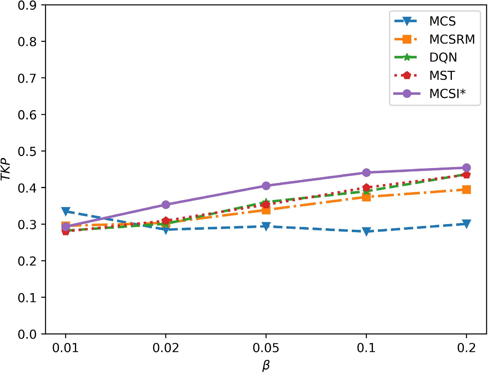
Figure 6.
The impacts of the target's global motion behavior on tracking performance.
Figure 7 demonstrates the effects of the target's escape time
$ {T}_{e} $ $ {T}_{e} $ 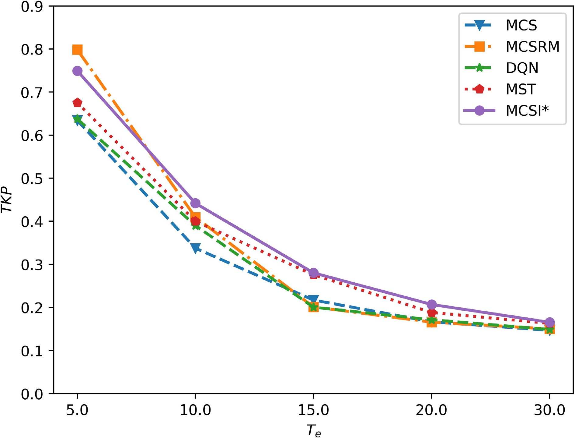
Figure 7.
The impacts of the target's evasive behavior on tracking performance.
Moreover, when
${T}_{e}$ ${T}_{e}$ It should be noted that in the current simulations, the target's global motion is generated using the same exponential-distance-based transition rule that the prediction model assumes. This deliberate consistency allows us to isolate the contributions of intention inference and online parameter estimation. In practice, however, a mismatch between the assumed and actual target behavior model is inevitable. A severe structural mismatch, such as when the target follows a fundamentally different decision rule or uses deceptive strategies, would undermine the validity of the likelihood model and degrade the accuracy of intention inference. Addressing such scenarios through data-driven behavior modeling that relaxes strong parametric assumptions remains an important direction for future work.
Sensitivity analyses
-
In this subsection, we explore the impact of key parameters (
$ N_{p}^{MCTS} $ $ {H}_{p} $ $ \gamma $ $ N_{p}^{MCTS} $ $ N_{p}^{MCTS} $ $ N_{p}^{MCTS} $ $ N_{p}^{MCTS}=200 $ $ {H}_{p} $ $ \gamma $ $ {H}_{p} $ $ \gamma $ 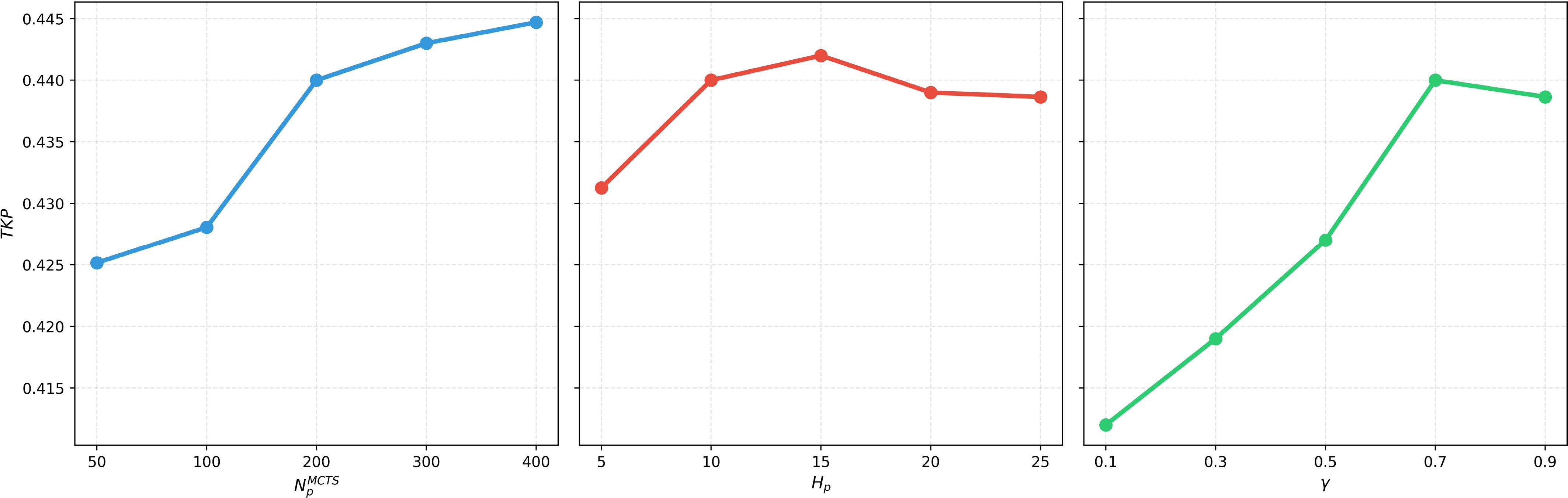
Figure 8.
The impacts of the key parameters on tracking performance.
Operating cost and complexity analyses
-
The algorithm's operating cost and complexity are primarily determined by three core components: Intention inference, trajectory prediction, and MCTS-based planning.
Intention inference
-
The Bayesian update of the target's intent (Equation (4)) involves calculating the posterior probability
$ P({g}_{T}|x_{T}^{0: t}) $ $ G $ $ O(G) $ $ \hat{\beta } $ $ O(1) $ Trajectory prediction
-
The MCSI method samples
$ N_{T}^{MC} $ $ L $ $ O(N_{T}^{MC}\cdot L) $ $ N_{T}^{MC} $ MCTS-based planning
-
The MCTS planner is invoked when the target is outside the UAV's FOV. Each planning cycle runs
$ N_{p}^{MCTS} $ $ {H}_{p} $ $ O(1) $ $ {H}_{p} $ $ O({H}_{p}) $ $ O(N_{p}^{MCTS}\cdot {H}_{p}) $ In summary, the computational complexity of the algorithm is primarily dominated by trajectory prediction and MCTS-based planning, with the overhead incurred by intention inference being negligible. In the simulation environment, a single algorithm's operating step can be completed in less than 20 ms on a standard laptop (CPU: AMD Ryzen 7 7840HS; Memory: 16.0 GB, 6,400 MT/s), which demonstrates the real-time applicability of the overall framework.
-
The results presented above indicate that both intention inference and online estimation of the behavioral parameter can materially enhance tracking performance. Nevertheless, in operational settings with adversarial targets, reliable behavioral models are difficult to obtain. Moreover, targets may act nonrationally, limiting the accuracy of intention models and making intention prediction particularly challenging.
A viable strategy for addressing this issue involves using deep neural networks to model the behavior of the target, with real-time updates to the model parameters according to the observed trajectory of the target. However, a significant challenge in this approach is the development of an efficient method for rapidly updating the neural network parameters. Moreover, as the uncertainty surrounding the target's behavior increases, accurately predicting its intentions and trajectory becomes more complex, which hinders the ability of a single UAV to maintain continuous tracking. In contrast, the utilization of multiple UAVs offers a promising solution. On the one hand, multiple UAVs have greater detection capabilities and can achieve rapid search and detection within the environment to quickly discover the target; on the other hand, coordinated multi-UAV deployments enable deliberate interaction with the target, reducing behavioral uncertainty, which, in turn, simplifies intention inference and supports persistent tracking.
-
This study explores the challenge of UAV-based tracking for a target that exhibits evasive behavior in an urban environment. Unlike previous research, the focus here is on targets that can evade tracking through rapid acceleration. To enhance the UAV's ability to locate an escaped target swiftly, the planning process is informed by inferring the target's intentions and predicting its trajectory. Additionally, the target's behavioral parameter is updated online from its observed motion. The simulations indicate that intention inference effectively steers the UAV's planner, and online parameter estimation yields substantial gains in tracking performance. Nonetheless, as the target's evasive capabilities increase, maintaining continuous tracking becomes increasingly challenging for a single UAV. Moreover, accurately modeling and estimating the target's behavior in real time presents practical difficulties. Future research will focus on developing cooperative tracking strategies involving multiple UAVs and constructing behavior models based on real-time trajectory data from the observed target.
-
The authors confirm contribution to the paper as follows: study conception and design: Yan P, Lu Z, Zheng H, Guo J; data collection: Bai C, Yan P, Ban X; analysis and interpretation of results: Lu Z, Zheng H, Guo J, Ban X; draft manuscript preparation: Yan P, Bai C, Zheng H. All authors reviewed the results and approved the final version of the manuscript.
-
The data are available from the corresponding author upon reasonable request.
-
The authors declare that they have no conflict of interest.
- Copyright: © 2026 by the author(s). Published by Maximum Academic Press, Fayetteville, GA. This article is an open access article distributed under Creative Commons Attribution License (CC BY 4.0), visit https://creativecommons.org/licenses/by/4.0/.
-
About this article
Cite this article
Yan P, Lu Z, Bai C, Zheng H, Guo J, et al. 2026. Intent-informed UAV tracking for evasive targets in urban environments. International Journal of Micro Air Vehicles 18: e016 doi: 10.48130/mav-0026-0017 

Intent-informed UAV tracking for evasive targets in urban environments
- Received: 04 December 2025
- Revised: 30 April 2026
- Accepted: 13 July 2026
- Published online: 08 October 2026
Abstract: The utilization of unmanned aerial vehicles (UAVs) for the search and tracking of targets within urban environments is a well-researched area with broad applications. However, there has been limited research addressing the challenge of tracking targets exhibiting evasive behavior. Such targets can escape the UAV's tracking through adversarial movements. In response to this issue, the present study introduces a comprehensive framework for target tracking that integrates inference of the target's intentions with trajectory prediction. In this framework, the target's intention is characterized by potential goal regions, and the trajectory data of the observed target is utilized to infer these intentions within a Bayesian context. Conditioned on the inferred intention, the target's future motion is predicted through sampling. The resulting trajectory forecast underpins a planning method that seeks to maximize the cumulative future detection probability. Simulation results indicate that inference of the target's intentions significantly enhances the UAV's search efficacy and improves overall target tracking performance.